MyGuide Map: Greenwich: Guide Book (No route)
 Check out the android app this map is from.
Scroll through this page to see all the content, or you can tap/click on the points to see what's there if you open the interactive map
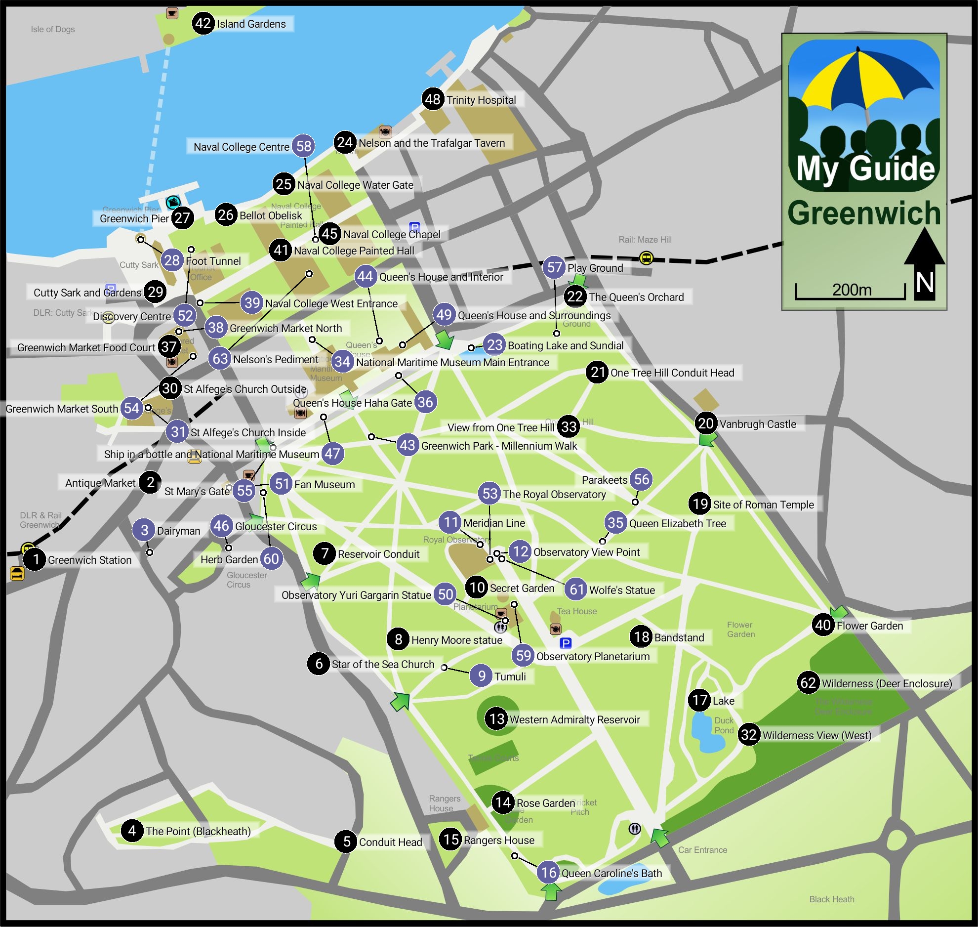
Points of Interest Map Ref
The various points of interest shown on the map are listed below in sequence. You can search for something using the search button above.
It is so much easier to do this in the app plus you have the benefit of location enabling and audio commentary!
Greenwich Station 1.1

Greenwich Station
If you have arrived by train then you have travelled along the first suburban railway line in London which was completed in 1836, but not extended to Greenwich until 1838.
At that point Greenwich became the terminus for trains running from Spa Road in Bermondsey (near London Bridge).
The driving force behind the railway was George Landmann who had been born in Woolwich.
After a distinguished career as a military engineer, he became interested in railways and in 1831, with a partner, floated a company called "The London and Greenwich Railway" to design and build this line.
In 1833 it received the parliamentary approval required to start building.
The railway is 3.
4 miles long and carried on a single viaduct consisting of 851 brick arches and 27 bridges which were able to carry the trains over the existing roads.
He employed 400 workmen who in 3 years laid over 60 million bricks, the sheer number of bricks causing a brick shortage in the country.
The rather attractive and smart station building in yellow London stock brick dates from 1840 and is, therefore, one of the oldest remaining train stations in the world (the oldest dating to 1830) and is of particular interest as it was personally designed by George Landmann.
It was another 30 years before the engineers had another idea to avoid roads and built the first underground railway.
Back to the interactive map
Antique Market 2.1
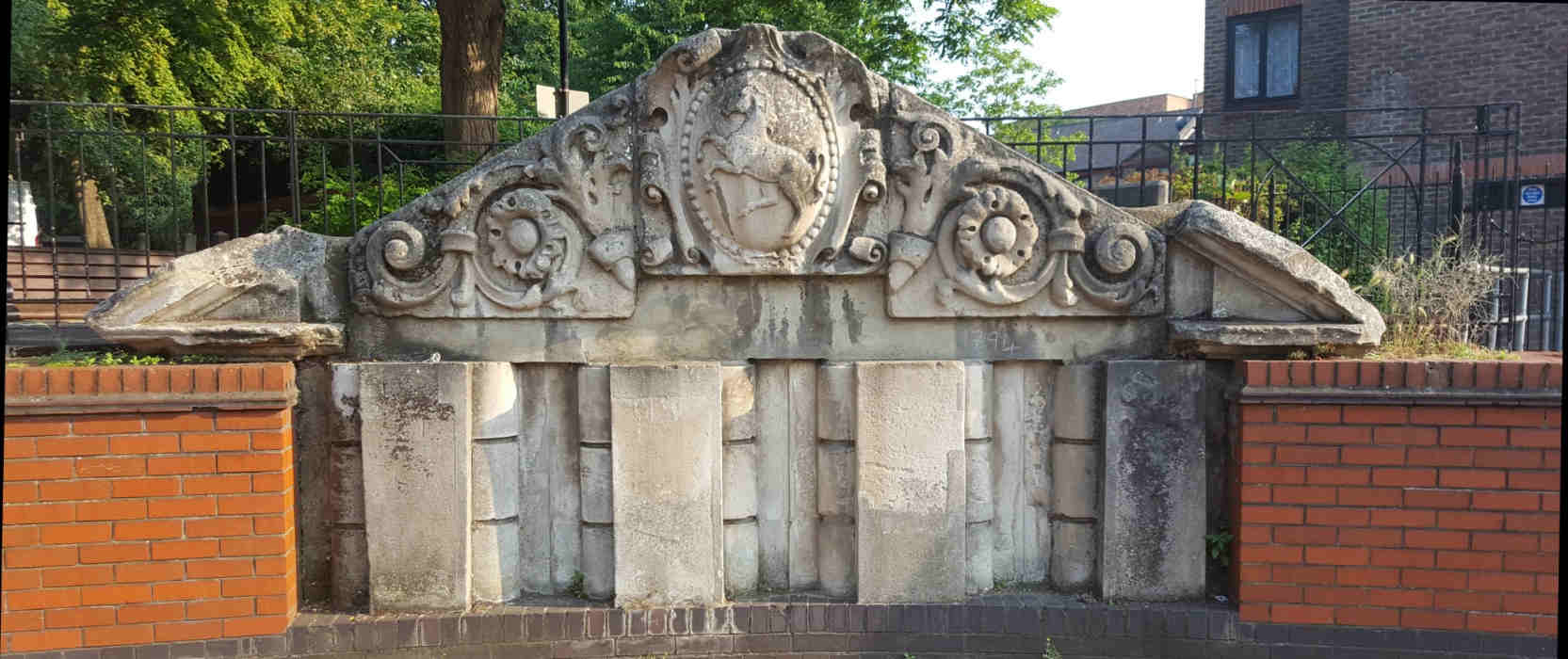
Antiques Market
Just next to the Picture House cinema you may find a market specialising in antiques depending on the day of your visit.
Venture to the back and you will find two large pieces of stonework from the workshops for the blind set up by Major General Bainbrigge to provide employment to the blind of Kent.
There was a shop which sold the various items of chandlery manufactured, such as ship fendoffs, cork filled life-buoy cushions, baskets, rugs, caned chairs, ship brooms, baskets, rugs and mattresses.
It was James Nasmyth who funded the building in 1892 and you can see his name in the inscription.
He was made his fortune from the invention of the steam hammer, but was also an artist and photographer.
The workshop moved to Peckham in 1972 to make way for the hotel and cinema that take their place today
A Second Railway Station
What you will find little sign of today is that this area once had a railway station which opened in 1888 and was called "Greenwich Park".
It was never very successful because the original line and station from 50 years earlier remained more popular.
It was eventually closed in 1917 having run at a loss for many years.
The old station building was used as a billiard hall until it was eventually demolished in the 1960s.
Today the Ibis hotel stands exactly where the station building once was with the car parks here being the site of the platforms.
Back to the interactive map
Antique Market - James Nasmyth 2.2
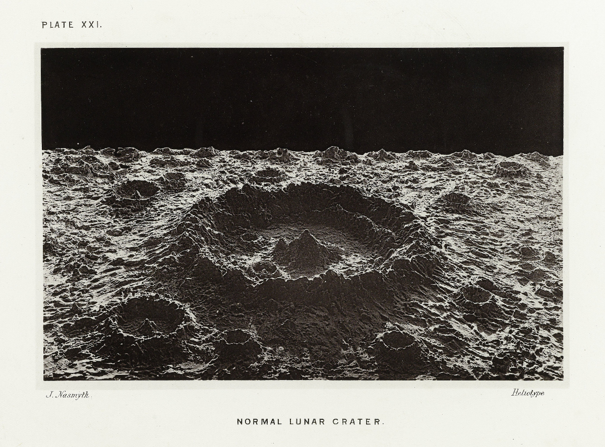
The Moon, Considered as a Planet, a World and a Satellite.
James Nasmyth was fascinated by astronomy and had a large telescope built so he could study the stars.
He also spent a lot of time making detailed drawings of the moon.
Working with James Carpenter, an astronomer at the Royal Observatory, in 1885, he published a detailed book about the moon, mapping its surface and using his artistic skills to provide some astonishing photographic images of the moon's surface.
To create the photographs he made detailed models of his drawings in clay and then took photographs of these with strong directional lighting so that the images looked as life-like and dramatic as possible.
The authors had concluded that the moon was geologically active and the craters on the moon were volcanic in origin as this was how they formed on Earth.
Although we now know the craters were formed by asteroids and other bodies hitting the moon, the book is still to be admired for the detail it provided on our nearest neighbour.
Back to the interactive map
Dairyman 3.1
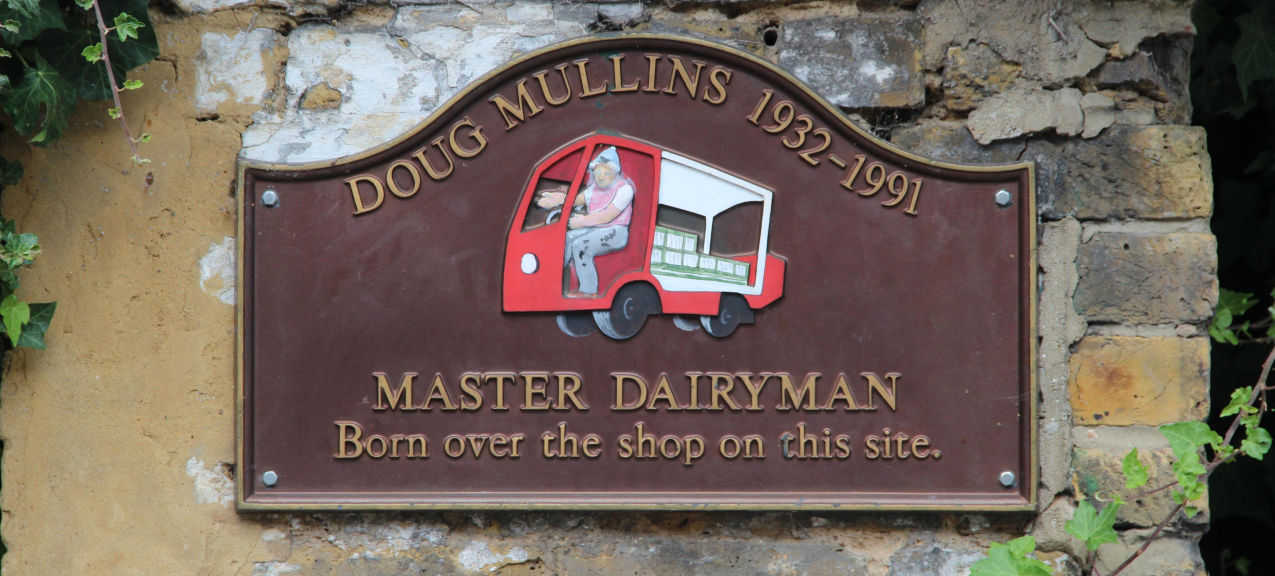
Dairyman
Doug Mullins was the last of a family of milkmen who served the local community from 1926 to 1991, with Doug taking over from his father Bill after his death in 1980.
Tragically Doug collapsed outside his shop, which was on this site, and died shortly afterwards in Greenwich Hospital.
As a local celebrity his funeral was very well attended and this plaque showing his red and white milk float was erected to commemorate both his death, and the passing of the era of the clanking bottles and cheery smile of a local milkman.
Back to the interactive map
The Point (Blackheath) 4.1
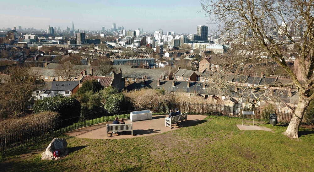
The Point
The point offers another impressive view across London this time from the North West edge of Blackheath at the top of Royal Hill.
It is the best view point for sunsets and also affords a very good long distance view of the Central London new years eve fireworks so can be quite busy that night!
Jack Cade's Caverns
Under The Point are some caverns known as Jack Cade's caverns named after the leader of the popular revolt of 1450 by the people of Kent against their mistreatment by the army of King Henry IV.
Although he would have camped on Blackheath twice there is actually no evidence of him hiding in here after the revolt collapsed and he fled to Sussex.
The caverns are actually chalk mines from the 17th Century.
As a very pure form of limestone, chalk was used to make "lime" by lime burners to manufacture mortar.
Rediscovered by accident, they had a spell as a tourist attraction before closing in 1854 because of reports of some notorious parties that were being held there late at night.
The caverns were accessed by a flight of 40 steps and consist of three main chambers linked by passage ways one of which contains a well, which may be part of the reason that the legend of the caverns as a hiding place came into being.
The last time these caverns were viewed was in 1939 when they were briefly reopened to investigate whether they could be used as an air raid shelter, but they were not deemed suitable.
If you want to get a sense of what they would be like, your best bet is to visit Chislehurst caverns which are similar and still open today.
Back to the interactive map
Conduit Head 5.1
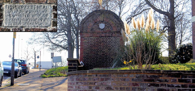
Hyde Vale Conduit Head
Before the advent of modern utilities, buildings or locations that required a significant and regular supply of water had to capture it from rain and springs and store it in a private reservoir.
The water collected was channelled through conduits either cut into the ground or dug out as underground "pipes".
It flowed by gravity to a storage site, in this case, the reservoir under Standard House 50 in the park due south of here.
(See entry in this guide).
Sometimes the water flow was made accessible at a higher point through a conduit head like this one.
Despite some later repair work and restoration, the Hyde Vale conduit head remains true to its original design and materials.
It was constructed about 1710, most likely by Hawksmoor, when the conduit system under Greenwich Park dating back to medieval times was restored and extended to form the water supply to the Royal Naval Hospital.
Back to the interactive map
Star of the Sea Church 6.1
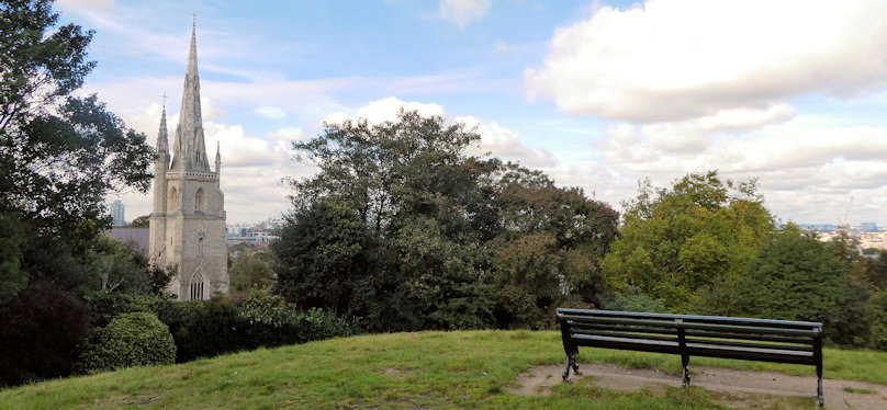
Our Ladye Star of the Sea Church
The first church here was built for catholic seamen from the Royal Naval Hospital, a reflection of the huge international and diverse population that the royal navy accumulated as the attrition from disease meant that it had to recruit new sailors in every port.
Rebuilt between 1846 and 1851 the church is now a prime example of the Victorian ideals of Catholicism and the 18th century obsession with gothic architecture.
Back to the interactive map
Reservoir Conduit 7.1
Reservoir Conduit
This building known as "Standard House 50" is the access point to an underground reservoir in the hillside behind it constructed around 1695 to provide fresh water to Greenwich Hospital.
It has a volume of 250 square metres and although it has not served its original purpose for a long time it was used during the second world war as an air raid shelter and even had toilets installed.
This building is the most conspicuous of a number of smaller constructions that allowed access to the maze of underground tunnels that exist throughout the park.
The courses of some probably date back to the original Tudor palace of Placentia, but all were modernised when the hospital was built and it is these that can be seen today.
Although these conduits are closed today, they are in many cases large enough to walk through and lined with red brick.
If on your journey round the park you see something that looks like there might be a tunnel behind it or under it, then there almost certainly is.
If you walk round the west side of the building you will see a vent stack and a drain cover.
These are old access points to the conduit which runs under here and then under the road and up to Hyde Vale.
Back to the interactive map
Henry Moore statue 8.1
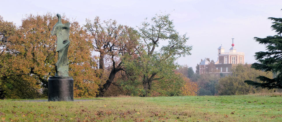
Large Standing Figure: Knife Edge
Henry Moore is a very recognised name and he has a very recognisable style seen clearly here in the Knife Edge.
Less well known is that he also had a passion for exhibiting his works in open space: "Sculpture is an art of the open air.
.
.
I would rather have a piece of my sculpture put in a landscape, almost any landscape, than in, or on, the most beautiful building I know.
"
"Large Standing Figure: Knife Edge" was finished in 1976 and is one of several statues called Knife Edge.
The sculpture is sometimes called Standing Figure (Bone) or Winged Figure.
The sculpture is based on a fragment of a bird's breastbone with the characeristic sharp diagonal detailing, to which a base and a rounded head have been added.
The resulting composition resembles a human torso and evokes comparison to classical greek sculptures.
Moore personally selected this location for his statue when it was installed in 1979, but following concerns over graffiti and a spate of thefts of Bronze statues to be melted down for scrap metal in 2007, it was removed by its owner, the Henry Moore Foundation, for safe keeping.
It was reinstated in time for the 2012 Olympics and it is hoped that the statue will remain where Henry Moore himself chose to place it for many years to come.
Back to the interactive map
Henry Moore statue - Henry Moore 8.2
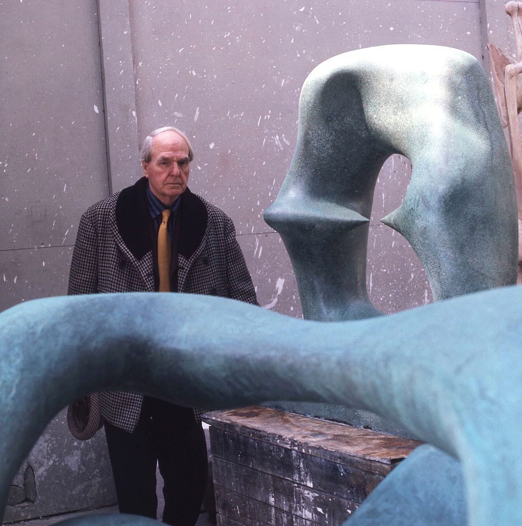
Henry Moore
Henry Moore is a key figure in British art and one of the world's best known abstract sculptors with prominent examples of his work in almost every major city.
Henry Moore's career was much influenced by war.
He started out as a teacher, but following the first world war where he survived a gas attack at the battle of Cambrai he moved into art using his ex-serviceman's grant.
During the second world war he became an official war artist and during this time established a strong reputation culminating in a retrospective of his work at the New York Museum of Modern Art in 1946.
Back to the interactive map
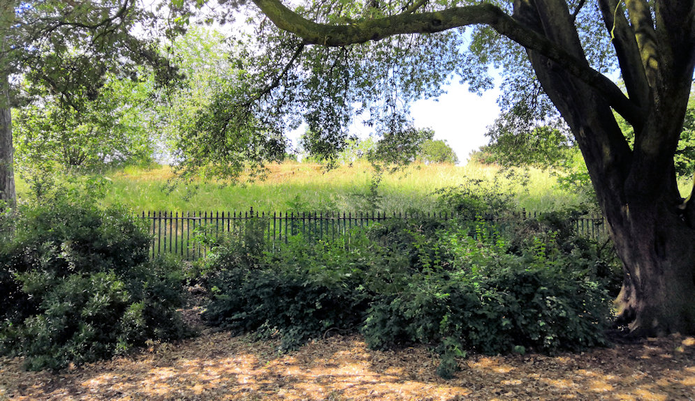
Tumuli 9.1
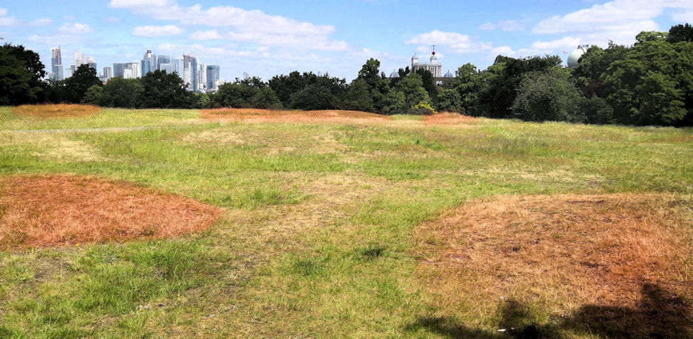
Tumuli - Ancient Burial Site
In this area you will find several low mounds either side of the paved path.
These are ancient burial mounds that are over 1,300 years old and were built by the Anglo Saxons within an ancient cemetery of over 30 barrows of which these are the remains.
Although they may not look especially impressive today, this is one of the best preserved sites in the country.
It is a scheduled historical monument and several important artifacts have been found in excavations over the course of the last 300 years including swords and jewellery.
Back to the interactive map
Secret Garden 10.1
Secret Garden
Greenwich locals usually refer to this garden, which was once part of the Observatory, as the "Secret Garden", presumably because it is well hidden despite being in the centre of the park.
Its sheltered and shady location give it a pleasant microclimate and it is the ideal place for a secluded picnic on a hot summers day.
The present entrance was only built in the 1960's and prior to this the garden was part of the observatory and private being accessed directly from the basement of Flamstead House through a tunnel.
Unfortunately the tunnel no longer exists but you can climb up and walk through the paths between the flower beds to get a feeling of how arrival by this unusual method may have felt.
Back to the interactive map
Meridian Line 11.1
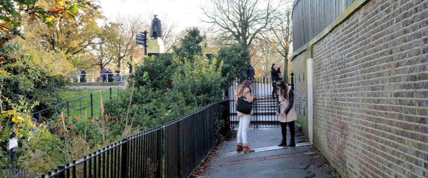
Zero Degrees
The brass strip in the path here indicates the position of the Greenwich Prime Meridian, so standing astride this line you are partly in the Western Hemisphere and partly in the Eastern Hemisphere.
You can also see the meridian line when visiting the observatory in the courtyard.
It extends in a northerly direction just passing by the west side of the O2 and at night is illuminated by a laser beam.
The first Royal Astronomer at Greenwich, John Flamstead, was given the task of improving the accuracy of the star charts used for navigation by accurately recording and documenting them from the observatory.
As the star measurements were made using a telescope on this line, Greenwich was the reference point and so became zero degrees, neither east, nor west.
The observatory museum will show you some of the telescopes that were used in this work and also covers the important development of accurate clocks that did not need a pendulum by John Harrison.
Back to the interactive map
Meridian Line - Navigation by the stars 11.2
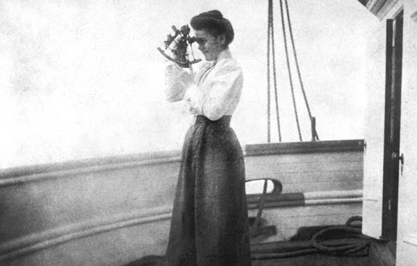
History of Star based Navigation
When the observatory was founded by Charles II in 1675, ships could work out very roughly where they were by locating the position of the sun or stars in the night sky.
To determine how far north or south you were from the equator was done by measuring the angle of Polaris the (Pole Star) to the horizon (or The Southern Cross if you were south of the equator).
Determining how far east or west you were was more challenging because the earth rotates in that direction.
The first thing you had to do was work out the time at your current location using the position of the sun or stars.
Then you needed to know what the time was at a known north to south meridian you had chosen.
Measuring the time using the stars was more accurate than using the sun as you could take multiple height readings for different stars.
To get the time you then had to reference tables of data to translate those angles into a time.
Measuring from the horizon was also made more accuate with the development of the sextant in the mid 18th century.
Apart from the need for a clear sky there were two practical problems with this method.
Firstly the star positions were not very accurately recorded and secondly there was no way to know what the time was at your chosen meridian as pendulum based clocks did not work on a rolling ship.
The work of John Flamstead at the observatory produced the star position tables so that solved the first problem and made Greenwich the default meridian position, but designing an accurate clock that would work on a ship was another matter altogether.
A pendulum based clock was great on dry land where it stayed still and the pendulum swing was a constant frequency, but useless on a ship where even gentle rolling made the pendulum's swing eratic.
The solution to this was developed by John Harrison and replaced the pendulum with a spring loaded oscillating flywheel which moved constantly independent of its orientation, but there were many other engineering innovations required to deliver the required accuracy.
With an accurate clock, a clear sky, and the Greenwich Observatory star data, ships could now tell where they were to within a mile or so, a major breakthrough in safety for all those at sea.
Back to the interactive map
Meridian Line - Really Zero Degrees? 11.3
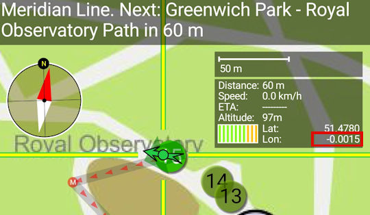
Is this Zero Degrees?
Some of you may be puzzled that your GPS coordinates do not show zero longitude when you are standing on the meridian.
Your GPS will place the meridian about 100 meters east of here.
This is because GPS uses a modern global standard called WGS84 designed to best fit longitude and latitude accurately to existing maps.
Based on this requirement, and the shape of the earth, it had to select its own new meridian line.
Hopefully you are not too disapointed now.
Back to the interactive map
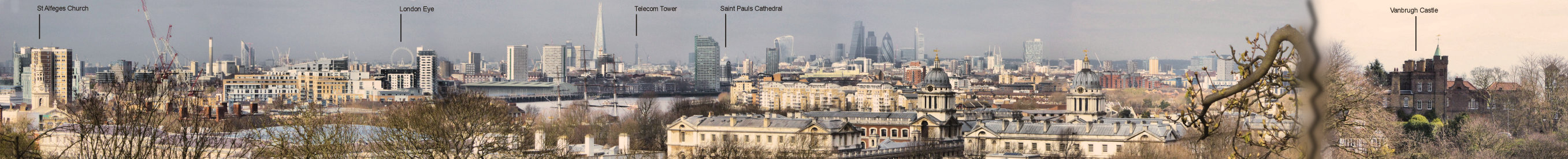
Observatory View Point 12.1

View from the Observatory
There is a lot to see from this vantage point which has been made more interesting by the development of Canary Wharf.
Apart from the obvious features of Greenwich, including the best view of the Queen's House and Maritime Museum, there is an excellent view of eastern London, including the financial district: the City.
From left to right look out for St Paul's Cathedral, the tall thin telecom tower, the City with all its unusually named towers (Shard, Cheese Grater, Gerkhin, Tower 42 and Walkie-Talkie).
Then you have the Cutty Sark, Canary Wharf with its expanse of office blocks and before the Dome you have a great view of the chimneys of Greenwich's own mini Battersea Power station, which is still used to power London Underground.
The hill you are standing was much altered during the great landscaping of Charles II.
Not only was the Observatory built, but the actual slope before you was carved into terraces lined with hawthorn hedges.
By Victorian times the slope had been restored and it was a popular pastime to go running down the hill trying to stay standing, especially during the Greenwich Fair (see "The Pier").
Back to the interactive map
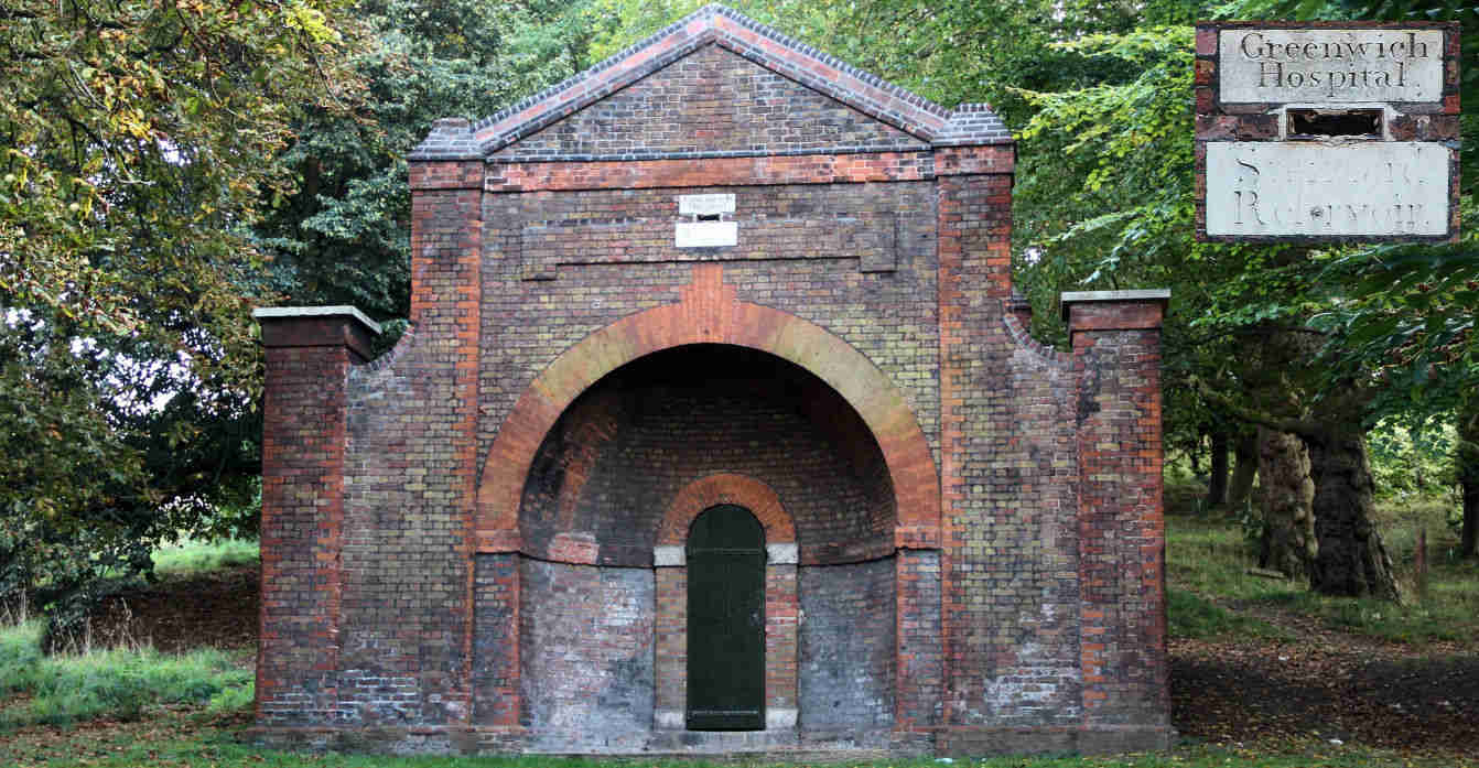
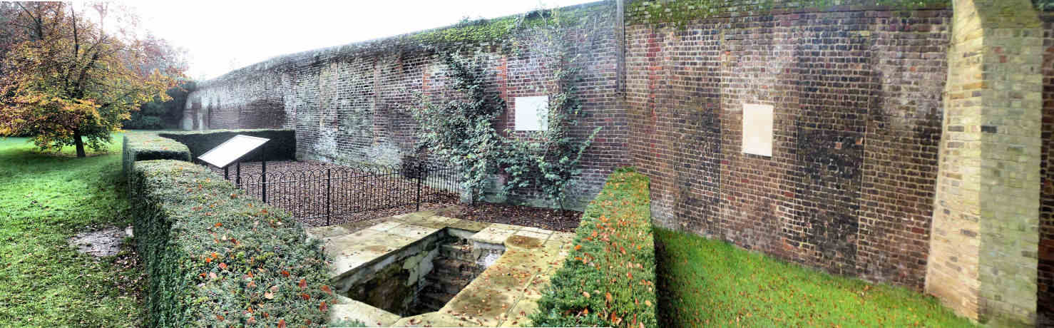
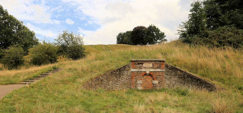
Western Admiralty Reservoir 13.1
Western Admiralty Reservoir
The reservoir is no longer used and is covered and fenced off so you can only walk around its perimeter and imagine the inside which is extremely impressive.
It was built in 1844 by Sir William Denison to improve the water supply to Greenwich Hospital and the naval dockyard at Deptford where he was the chief engineer.
It is part underground and part above ground.
With a circumference of over 250 metres and a capacity of 5,000,000 litres, it is the largest single structure that fed the maze of historical water conduits under the park.
It is directly connected to the reservoir under Standard House 50 listed in this guide as Reservoir Conduit.
It was only used for 26 years before the hospital was closed and at that point the building was grassed over and screened by trees as it is now.
If you were able to climb down into the building you would find yourself enjoying both the echos and architecture of a huge circular cavern.
It is built in red brick as a set of concentric circular arched roofs supported on columns where they join, providing a large circular space to contain the water.
Back to the interactive map
Rose Garden 14.1
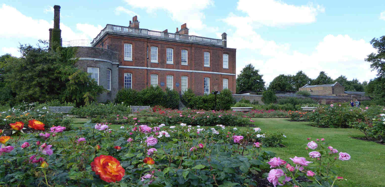
Rangers House and Rose Garden
Installed in the 1960's its fairly obviously the Rose Garden is only really worth visiting between June and July when everything is in bloom and full fragrance, but if you are in the park during those months, and love the sight and aroma of roses do take a look.
Rangers House was built in 1699 by Captain Francis Hosier in a simple Palladian style and was the first house to be sited near the Royal Observatory which had been completed only four years earlier.
If you want to visit Ranger's House you will need to exit the park unless the small gate on the left side is open.
Back to the interactive map
Rangers House 15.1
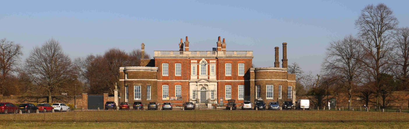
Rangers House
Rangers House was built in 1699 by Captain Francis Hosier in a simple Palladian style and was the first house to be sited near the Royal Observatory which had been completed only four years earlier.
Hosier was a vice admiral in the navy and probably made his fortune from booty gained by capturing enemy ships.
The location of the house would have given him excellent views over the nautical activities in Greenwich and on the Thames.
After he died in 1727 while blockading the Spanish in the West Indies, the ownership of the house was contested and it took until 1740 for it to pass to his mother's family at which point it was immediately leased to the Earl of Chesterfield.
On the earl's death, his son, Lord Chesterfield, took over the lease and had the building extensively remodelled, becoming his favourite "villa".
The role of Ranger of Greenwich Park was first given to Caroline of Brunswick, but after she left the country and her house was demolished, Chesterfield House, as it had become known, was purchased by the crown and in 1815 became the official residence of the Ranger of Greenwich Park with the appointment of Princess Sophia Matilda, the first in a long succession of royal "grace and favour" occupants.
In 1902 the last Ranger left the house and now English Heritage have installed the collection of Julius Wernher who built his wealth from South African diamonds being one of the founders of the still famous "De Beers" company.
Although Wernher never lived in Ranger's House, the others that did live there used it to house their collections and so we could look on Julius Wernher as the last, but posthumous, occupant.
More details can be found on their website: Ranger's House
Back to the interactive map
Queen Caroline's Bath 16.1
Queen Caroline's Bath
This deep bath is a remnant of Montague House and was only properly excavated in 2001.
It would have been situated in a luxurious bath house within a glass house.
Montague House was a large royal residence and home to Caroline of Brunswick, the wife of King George IV, between 1798 and 1814.
Her marriage to George IV was bitter and divided from the outset and consequently she lived separately from the King at Montague House where she was able to use her status as the Park Ranger to enclose the surrounding 5 acres of the park for her personal use and indulge in her favourite hobby of gardening.
Fed up with her treatment she eventually moved to Italy in 1814 and the King wasted no time in ordering the house demolished.
The walls of the house that adjoined the park boundary were retained and the bricked up spaces where the windows once were can be seen here in the wall behind the bath.
Back to the interactive map
Queen Caroline's Bath - Caroline of Brunswick 16.2
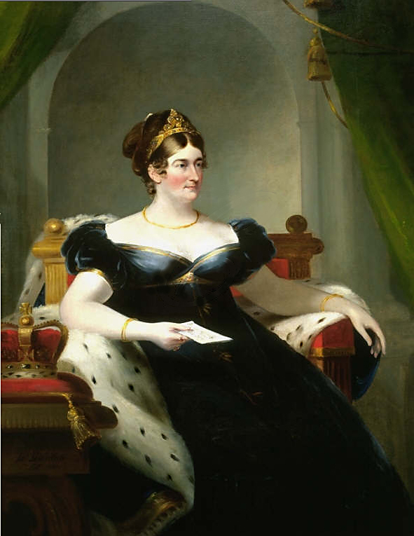
Caroline of Brunswick
Caroline's arranged marriage to George IV started as it was to continue with George having already illegally married a member of the court called Maria Fitzherbert.
Caroline was no pillar of virtue and disliked George as much as he disliked her.
She also had a reputation for being eccentric and unhygienic.
The loveless marriage did produce one daughter, Charlotte, after which the couple separated since the sole purpose of having the child was to get parliament to pay off his debts.
George vindictively used Princess Charlotte as a means to antagonise Caroline, refusing her permission to see her.
Eventually she had had enough of this treatment and Caroline left Britain for Italy in 1814.
After leaving for Italy she remained a very popular figure in Britain and counted Jane Austin as one of her fans: "Poor woman, I shall support her as long as I can, because she is a Woman and because I hate her Husband.
" George IV was heavily despised and when he tried to formalise the divorce it was clear that because of her popular support the House of Commons would never pass it.
To get her to agree he gave her a pension of 50,000 pounds per year, the equivalent of about 4 million pounds today.
Although she loved gardening, this modest daytime activity was in stark contrast to the raucous evenings when she held extravagant parties or would entertain her various lovers.
Back to the interactive map
Lake 17.1
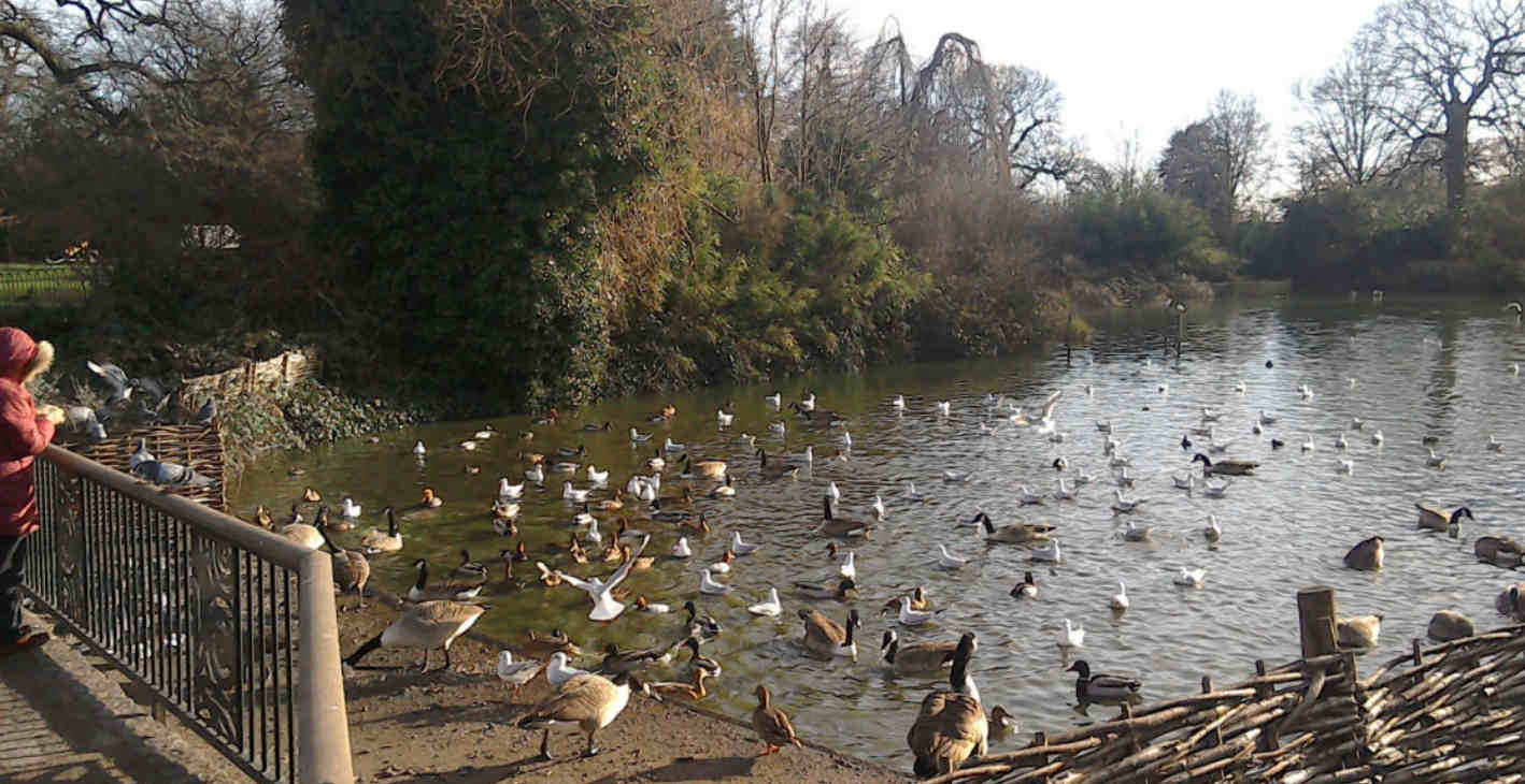
The Duck Pond
The duck pond, or "lake" was introduced to the park as a water feature for the flower garden in the late 19th century and was intended to showcase water loving plants.
In the avian world, word obviously got round that there is plenty of free food going here and as a result the pond in Greenwich Park must have the largest collection of ducks per square metre in the whole of London.
Back to the interactive map
Bandstand 18.1
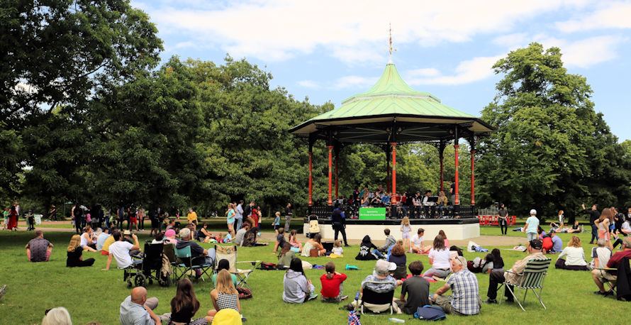
Bandstand
As the industrial revolution brought more and more people into the cramped cities and their slums, Victorian town planners recognised the importance of open spaces like parks to maintain good health and public order and wanted to encourage the population to use them.
The idea of brass bands playing in purpose built bandstands proved extremely popular and soon became an essential feature of any respectable Victorian park.
The Greenwich Park bandstand is made of iron following a standard format that was used across the whole of Britain.
It was assembled in 1891 having been cast in sections at the famous Coalbrookdale works in Shropshire, where Abraham Darby had first set up his furnace in 1709, the start of the modern iron industry.
Today the bandstand still occasionally hosts brass bands in the summer, as well as more unusual ensembles, most often on a Sunday, but is also used as a focal point for many of the events that take place in the park.
Back to the interactive map
Site of Roman Temple 19.1
Site of Roman Temple Complex
Unfortunately there is nothing to be seen here today and you will need to use your imagination.
On the mound here stood a Romano-Celtic temple dating back to the start of the Roman occupation of Britain in AD43 and in use for most of the Roman period.
Roman temples were centres for healing, pilgrimage and worship which would have included making offerings to the gods.
At the top of the escarpment the site would have been visible from the river and also to travellers on Watling Street, the main Roman road between Kent and London, which also passed close by.
This site was first excavated in 1902 and three main areas were revealed.
One of these was part of a tessellated pavement (small squares of tile set in mortar) a tiny portion of which used to be displayed here behind railings.
Subsequent excavations, including one televised in 2000 by "Time Team" found that the complex was extensive and uncovered various artifacts that support it being the site of a temple, including part of an inscription to Jupiter.
Back to the interactive map
Vanbrugh Castle 20.1
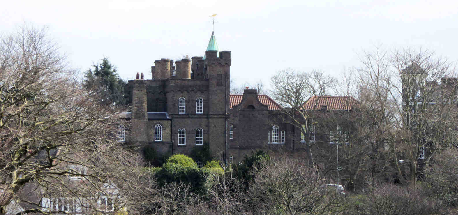
Vanbrugh Castle
Vanbrugh Castle is privately owned so you can only admire it from the outside.
It is not a castle in the true sense, it is actually what is often called a folly, a term for an overly extravagant or mainly decorative building.
Built by Sir John Vanbrugh in the likeness of the Bastille Prison in Paris where he had been incarcerated on spying charges for two years, he lived here from 1719 to 1726.
It is now converted into luxury flats which are leased by the Blackheath Preservation Trust.
Sir John Vanbrugh combined two very different careers, as a pre-eminent architect he designed some of Britain's most famous stately homes, notably Blenheim Palace and Castle Howard, and as a dramatist he wrote restoration comedies such as 'The Provoked Wife'.
He even managed to combine these activities by designing and building the Haymarket Theatre in central London.
Back to the interactive map
One Tree Hill Conduit Head 21.1
One Tree Hill Conduit Head
This conduit head provided access to the water flowing through the conduit tunnels built under the park.
It is a late 17th century conduit head built in a Classical style and most likely designed by Nicholas Hawksmoor who was the Clerk of the Works at Greenwich between 1698 and 1735.
The central arch, which is now bricked in, would have once provided access to the water in the conduit which flowed down from Blackheath via Queen Elizabeth's Oak.
Conduit heads and houses are rare with three of the thirty three significant examples located in Greenwich.
The plaque above the arch has an inscription which is now illegible
Back to the interactive map
The Queen's Orchard 22.1
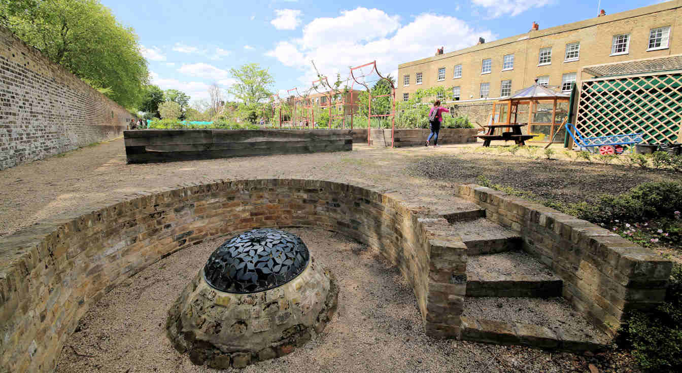
The Queen's Orchard
Staffed and maintained by volunteers, the Queen's Orchard was opened to the public on 15th April 2013 having been returned to the royal park by Greenwich council.
To reflect the legacy of the original Tudor orchards it has been planted with fruit trees that date back to the 14th Century and include apple, pear, cherry and others such as quince and medlar.
As well as the actual orchard there are also two ponds, a well and a number of raised flower beds.
The Orchard is usually only open in the summer on Sunday afternoons, but it may be open on other occasions.
The Queens Orchard
Back to the interactive map
Boating Lake and Sundial 23.1
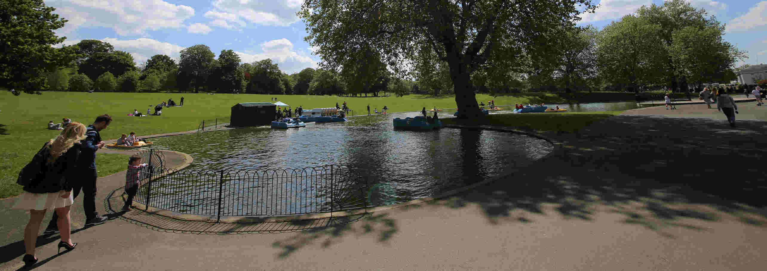
Boating Lake and Sundial
If you are visiting in the summer and really want to "push the boat out", then hire a pedalo and float around the boating lake for a while taking in the view of the observatory.
Next to the well-equipped children's playground, the boating lake has been a popular feature of the park since 1930, but is only filled with water for the summer months.
In 2012 it featured in the Olympics as a water jump for the equestrian cross country event.
The horses came down the hill entering on the south side, turned, jumped and exited on the east.
Details on hiring a boat can be found on their website.
Park Boats
Sundial
On the north side is a sundial which was designed by the celebrated sundial designer Chris Daniel and installed in 1999 to mark the new millennium.
Unfortunately it was meant to be on the meridian line, but is slightly off due to some construction mistakes, and, even worse, it is supposedly not quite oriented correctly so at noon is around 15 minutes fast! However, check the next tab, as this could simply be that some people are not clear how it works.
Back to the interactive map
Using the Sun Dial 23.2
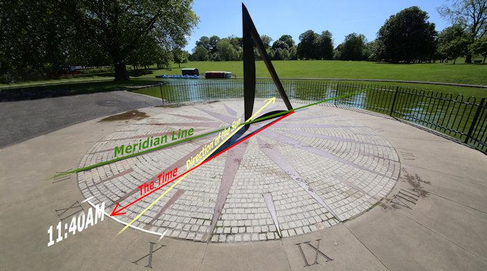
How the Sundial works
If it is a nice sunny day you can check out how the sun dial works.
This is a Double Horizontal Dial and is designed to show both the time and the direction of the sun.
The part that casts the shadow is made from bronze in the shape of a right angled triangle and known as the gnomon.
On the ground is the dial plate which looks like a compass rose.
The time is indicated by the shadow from the sloping edge of the gnomon and the direction of the sun is shown by the shadow from the vertical edge.
Unfortunately the shadow does not quite reach the dial.
Sun dials are obviously not the most accurate way of telling the time, but should generally be accurate to around plus or minus 5 minutes.
This one is particularly simple and so is less accurate than ones which take into account the seasons.
Do remember that the time it shows is Greenwich Mean Time and so will be one hour behind the actual time in the summer.
Back to the interactive map
Nelson and the Trafalgar Tavern 24.1
The Trafalgar Tavern
The Trafalgar Tavern opened in 1837 and was frequented by Charles Dickens as well as being home to the celebrated annual whitebait dinners of parliamentary cabinet ministers.
These took place in the function room upstairs and the last of these dinners had William Gladstone in attendance.
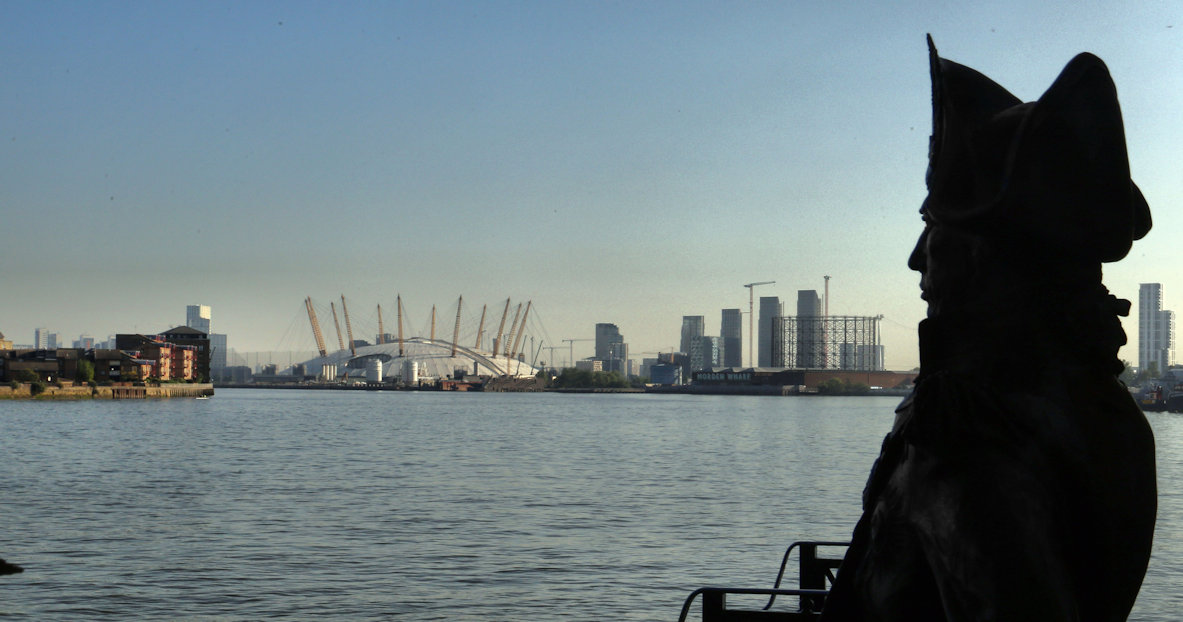
Just before the tavern there is a statue of Nelson and a great view down the river towards the O2 and the cable car.
Running down the side of the Trafalgar Tavern is Crane Street, typical of how all the streets in Greenwich would have appeared in the nineteenth century.
For more information on the Trafalgar Tavern visit their website.
The Trafalgar Tavern
Charles Dickens on Politicians
Politicians have always been publicly derided, and Charles Dickens had something to say on the matter:
"Why do Cabinet Ministers eat whitebait? And why do they eat them at the close of the parliamentary session in a tavern at Blackwall or Greenwich? Whitebait, being fish, are cold-blooded animals; but is there on this ground any analogy between them and Cabinet Ministers?"
Back to the interactive map
Nelson and the Trafalgar Tavern - Crane Street 24.2
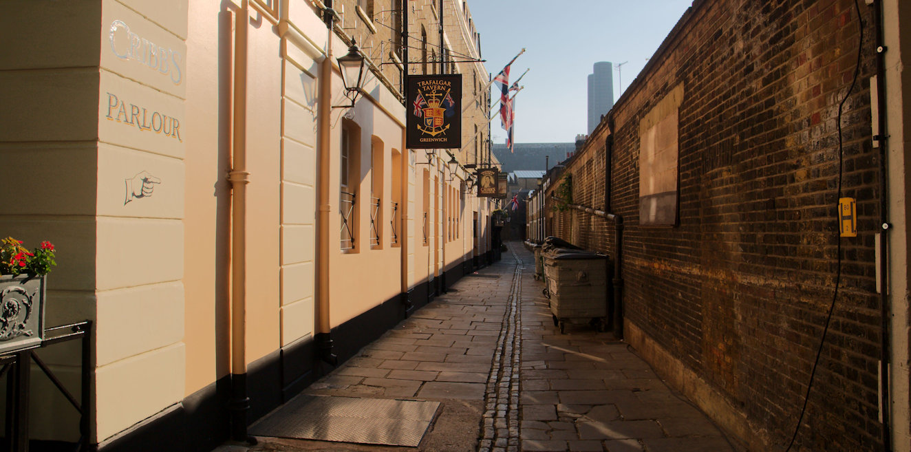
Crane Street
Just after the tavern, on the left, is a pedestrian alley way called Crane Street which is interesting in that it is what many of the streets around Greenwich would have looked like back in the 19th Century, narrow with a drainage channel running down the centre of the pathway.
It takes its name from the fact that at that time it had a crane for unloading ships cargo at the far end.
Unlike now, most of the buildings would have been weather boarded in horizontal overlapping strips of wood generally painted white giving a characteristic maritime feel to the area
Back to the interactive map
Naval College Water Gate 25.1
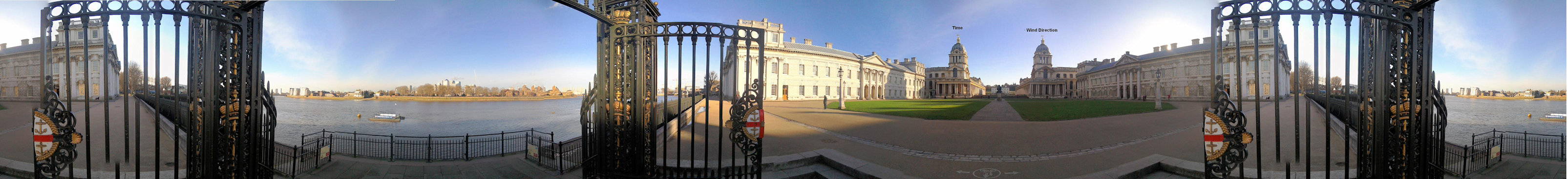
Water Gate
Water Gate is the entrance to the Old Royal Naval College or Hospital from the river Thames and is opposite steps allowing access to and from a boat.
In the centre of the gate, in two sections, you will find an example of the original coat of arms of the Royal Hospital with its four anchors bound in rope.
This is also an excellent point to take in the view towards the park and observatory and admire the buildings and symmetrical layout.
Facing the park you can see the two domed towers of the naval college.
There is a clock on the left tower and a dial on the right tower that looks like a clock, but shows the wind direction.
On your right is the oldest part of the Naval College which was constructed by Charles II after he demolished the original Palace of Placentia in 1664.
It was meant to be a new palace to rival the best in europe, but he abandoned the project before completion so this part stood alone and was never occupied.
It was eventually incorporated into the naval hospital by the architect Christopher Wren when building started around 1696 on the instructions of Queen Mary and William VI.
Consequently this building still has some ostentatious carvings around the entrances including the inscription "Carolus Rex II" unlike the building on the left which was added by Wren as a mirror image.
Also from here, the white Queen's House can be seen between the twin domes of the Naval College.
It had already been built by James I 30 years earlier in 1635.
Queen Mary insisted that its view towards the river be maintained and rejected the initial plans from Wren, because they included a single large central domed hall obscuring the view.
The final plans retained the two symmetrical buildings and added the two domes you see now.
Finally, this gate was used by the Naval College to serve passing honours to naval ships as they went by on the Thames.
This ancient tradition usually reserved for passing ships, involved senior officers piping from the deck of the ship and also from the steps of this gate.
Back to the interactive map
Naval College Water Gate - Greenwich Beach 25.2
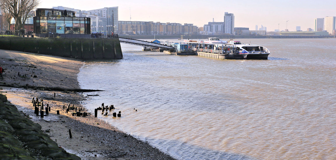
Greenwich Beach
Turning back to the river, if the tide is very low, then the steps here will lead down to what is known as "Greenwich Beach" which even has a small patch of sand near to the pier.
You will also be able to see the remains of oak piles sticking up out of the river bed which were part of a Tudor landing stage for the Palace of Placentia.
Conversely, if the tide is very high you will need to be careful as the path here often floods, especially if a fast ship goes by.
On the opposite side of the river you can see Island Gardens on a peninsula called the Isle of Dogs reputedly because Henry VIII kept his hunting dogs here.
Back to the interactive map
Bellot Obelisk 26.1
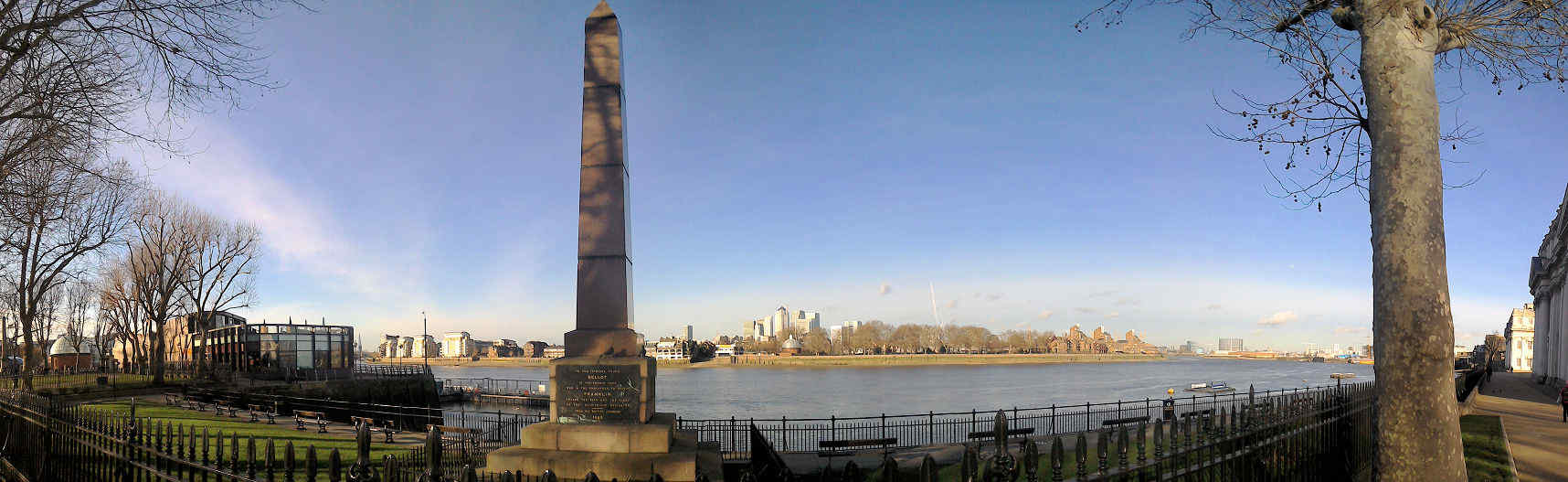
Bellot Memorial
Standing by the river path, this red granite obelisk is a memorial to a French man, Joseph Rene Bellot, who died in the Arctic aged 27.
It is a statement of his enormous popularity in Britain in the 1850's which was gained from his enthusiastic involvement in missions to locate the lost Franklin expedition, a major international news story at the time.
The monument was funded entirely by the public after Bellot's death in 1852.
It was designed by the architect Philip Hardwick who was the surveyor of Greenwich Hospital and unveiled in 1855.
Back to the interactive map
Bellot Obelisk - Joseph Bellot 26.2
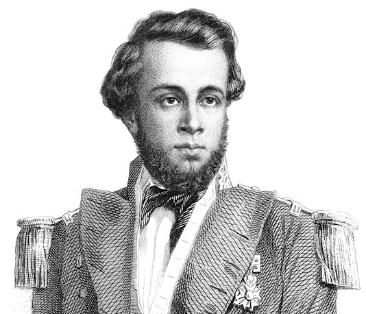
Joseph Bellot
Joseph Bellot was a Frenchman who first embarked from Greenwich in 1851 as a volunteer on H.
M.
S.
Phoenix under the command of Captain William Kennedy in search of Sir John Franklin.
In 1852 after promotion to the rank of lieutenant he accompanied Captain Edward Inglefield on another mission to find Franklin.
His personality, daring exploits and courage won him wide admiration at the time and he became a bit of a celebrity figure.
On August 18 1853, while making a perilous journey across an ice floe with two comrades, he suddenly disappeared through a crack and was never seen again.
He was just 27 years old.
As well as this Obelisk, he also has a small impact crater on the moon named after him on the southwest edge of Mare Fecunditatis.
Back to the interactive map
Bellot Obelisk - Franklin Expedition 26.3
Franklin Expedition
The fate of the Franklin Expedition retains much mystery even today.
In 1845 the experienced Arctic explorer Sir John Franklin set sail with 128 men in two reinforced and well equipped ships on a three year voyage to locate and chart the north west passage.
This long dreamed of route through the arctic would significantly shorten the journey to the Pacific from Europe if it could be found.
Nothing was heard from Franklin's expedition for two years and in early 1848 pressure from his wife and Parliament forced the government to commission a search party and sponsor rewards for anyone able to locate him and his men.
Such was the fascination with the arctic at the time, that many other countries and even individuals sponsored searches.
Tragically, the efforts were futile and although some artefacts and bodies were found with help from the native Inuit population, it was not until 2014, 150 years later, that the wreck of one of his ships, HMS Erebus, was finally discovered by a systematic sonar search undertaken by Park Canada.
HMS Terror, the other ship, was discovered 2 years later.
The full story remains unknown, but there is enough evidence to show that the usual summer thaw which would have freed the boats from the ice did not take place for two seasons and their supplies began to run out.
Trapped in this icy desert, the deprivation that these poor men suffered can barely be imagined and is witnessed in their desperate attempts to escape and stay alive.
Back to the interactive map
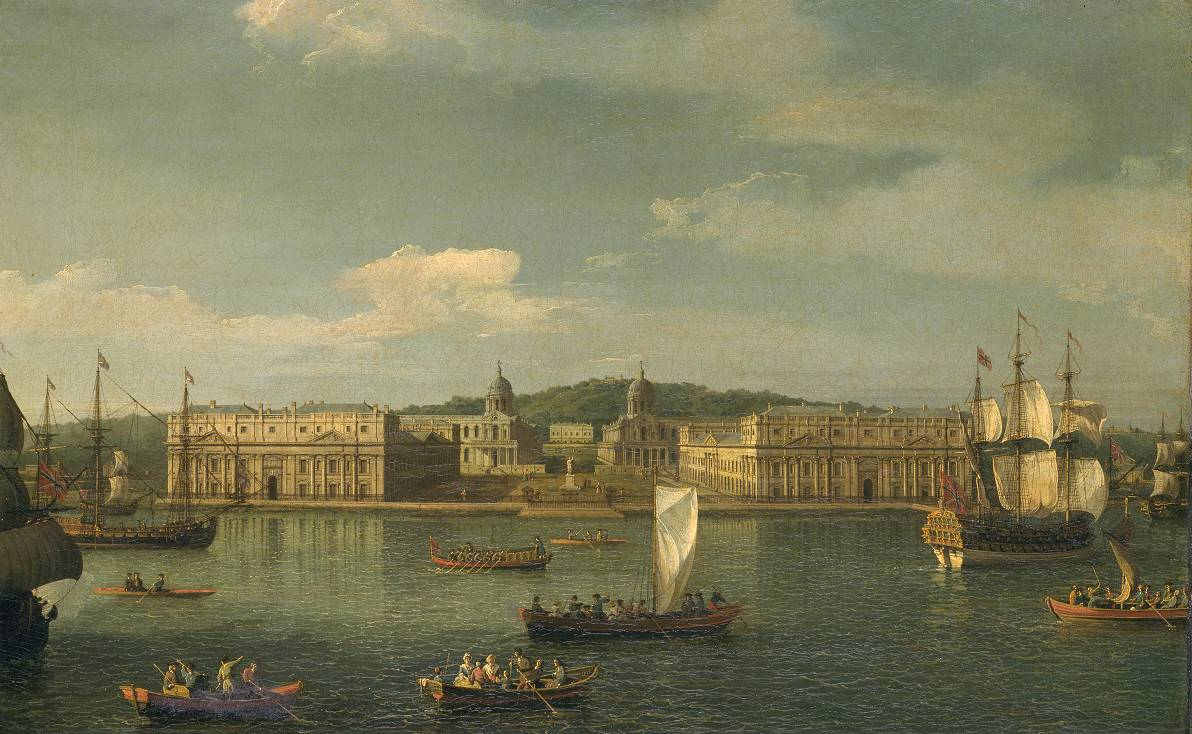
Greenwich Pier 27.1
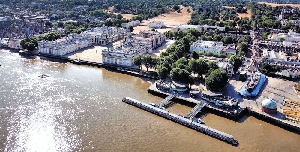
Greenwich Pier and Introduction
The pier is a great place to get oriented for your visit to Greenwich and if you have come by boat, that was a good choice because it gives an idea of how the river Thames has been so important in shaping Greenwich into the globally recognised cultural centre it is today.
If you have come by train, DLR, bus or car, then make your way here and stand with your back to the river.
To your right is the Cutty Sark.
Behind the buildings in front of you are the Park and Observatory.
To your left is the Old Royal Naval College.
These three areas contain the main sights of Greenwich.
If you came by boat you will have seen all these in the spectacular view of Greenwich and the park as you approach the pier, a view that has hardly changed in over 300 years.
Back to the interactive map
Greenwich Pier - A Brief History of Greenwich 27.2
Brief History of Greenwich
Greenwich has a long history and was first recorded by the Saxons in 918 as the settlement of Gronewic or "Green Bay" it was close to the river without being too marshy and had the high ground of Blackheath nearby.
Later the vikings used Greenwich as a base to attack London and in the Tudor era it became a favoured location for Kings and Queens, in particular Henry VIII and Elizabeth I.
With the growing importance of sea trade and the navy, it developed into a centre for maritime activity and innovation and became the home to an observatory and the prime meridian of the world.
Later came a hospital for infirm sailors, a naval college, a market and a maritime museum.
All the buildings are beautifully designed, but it is the symmetry and way that they fit into the landscape that makes Greenwich such a special place.
In recognition of this rich history and beauty, Greenwich became a UNESCO World Heritage Site in 1997.
In 2012, the Queen made Greenwich a Royal Borough reflecting its many important connections to the Royal Family.
Today Greenwich is home to a university, several museums and hosts numerous events every year reflecting its transition to a must-see tourist destination.
Back to the interactive map
Greenwich Pier - The Pier 27.3
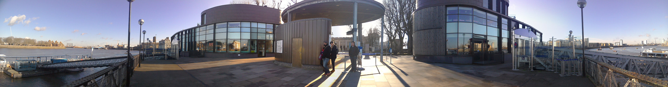
The Pier
Greenwich had always been a popular place to visit and Greenwich Pier was built in 1836 to accommodate the rapid growth of day trippers who were arriving by paddle steamers operating from central London and Kent.
It also served a ferry across the river to the Isle of Dogs before the foot tunnel was built.
Back to the interactive map
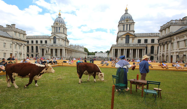
Greenwich Pier - Greenwich Fair 27.4
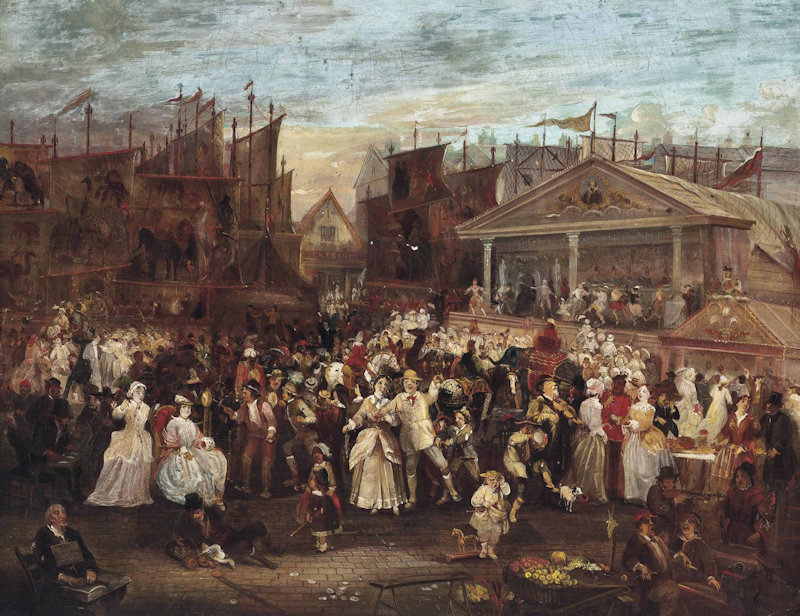
Greenwich Fair
These days visitors are drawn to the beauty and history of Greenwich, but for Victorians, Greenwich was not only a popular day out, its character was very much defined by the famous and outrageous Greenwich Fair.
This took place at Easter over three days and was eventually banned by act of parliament in 1857 following a petition complaining about its bad influence on the population of Greenwich and London as a whole.
Today the Greenwich and Docklands International Festival in June has reused the term Greenwich Fair for part of its list of activities, but it is nowhere on the scale or bawdiness of the original fair and instead attracts unusual street acts from around the world.
An idea of the atmosphere at Greenwich Fair can be gained from the author Charles Dickens who wrote about it in "Sketches by Boz".
Some extracts below give a flavour of how important it was in London life at the time, and just how outrageous it was.
"If the Parks be the lungs of London we wonder what Greenwich Fair is.
A periodical breaking out, we suppose, a sort of spring-rash: a three days fever, which cools the blood for six months afterwards, and at the expiration of which London is restored to its old habits of plodding industry, as suddenly and completely as if nothing had ever happened to disturb them.
"
"The chief place of resort in the daytime, after the public-houses, is the park, in which the principal amusement is to drag young ladies up the steep hill which leads to the Observatory, and then drag them down again, at the very top of their speed, greatly to the derangement of their curls and bonnet-caps, and much to the edification of lookers-on from below"
"Imagine yourself in an extremely dense crowd, which swings you to and fro, and in and out, and every way but the right one; add to this the screams of women, the shouts of boys, the clanging of gongs, the firing of pistols, the ringing of bells, the bellowings of speaking-trumpets, the squeaking of penny dittos, the noise of a dozen bands, with three drums in each, all playing different tunes at the same time, the hallooing of showmen, and an occasional roar from the wild-beast shows; and you are in the very centre and heart of the fair.
"
"The grandest and most numerously-frequented booth in the whole fair, however, is The Crown and Anchor a temporary ball-room we forget how many hundred feet long, the price of admission to which is one shilling.
There is no master of the ceremonies in this artificial Eden all is primitive, unreserved, and unstudied.
The dancing, itself, beggars description every figure lasts about an hour, and the ladies bounce up and down the middle, with a degree of spirit which is quite indescribable.
"
Back to the interactive map
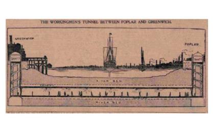
Foot Tunnel 28.1
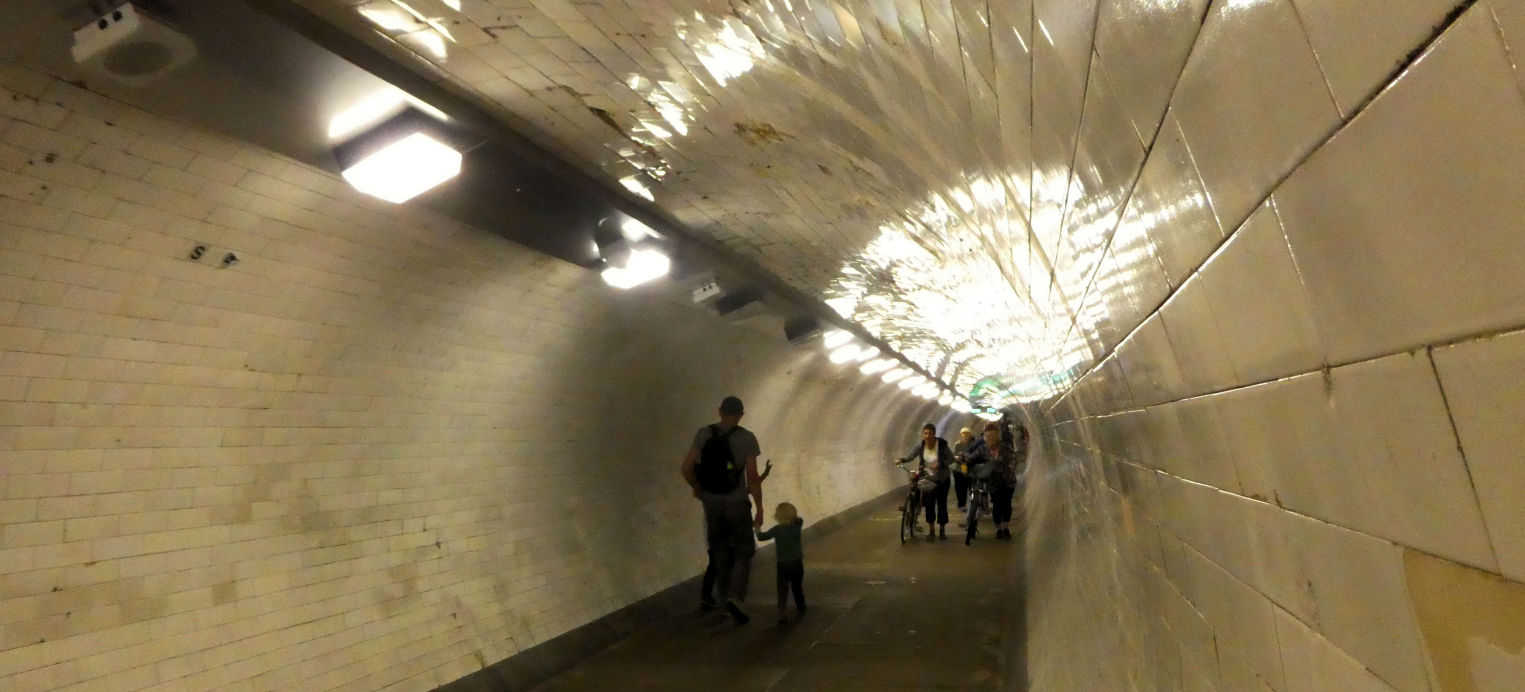
Foot Tunnel
Close to the river, this small circular building with its unusual glazed dome roof which is lit up at night is the entrance to the Greenwich foot tunnel.
The tunnel is a busy route for tourists and commuters, especially cyclists, with over 4000 people using it every day and it is probably best to avoid the "rush hour" in the morning and evening to have an enjoyable and quiet visit.
Unfortunately the lifts are not very reliable so you might have to take the stairs of which there are 100 on the South side, but only 87 on the North side.
Once in the tunnel the most striking feature is the 200,000 white glazed tiles that cover the walls making it seem especially bright.
You will notice that the tunnel narrows at the north end because of some steel reinforcement over the tiles which had to be added after a second world war bomb exploded in the Thames and caused the tunnel to leak.
It is worth making the effort to decend the 15 meters under the Thames and then walk the 370 meters of the tunnel as the view back to Greenwich from the Isle of Dogs is particularly lovely.
You can also say that you walked under the Thames.
Back to the interactive map
Foot Tunnel - History 28.2
History
For many years the only way to get to the Isle of Dogs on the north side of the Thames was to take the steamboat ferry from the pier, or a wherry, a traditional small ferry boat.
These were operated all along the river by the Thames Watermen who made their living carrying people and goods across the river for a small fee from numerous steps situated along the banks like the ones just behind the tunnel entrance or those at the front of the naval college (Water Gate).
The Isle of Dogs contained the main port of London which was critical for the import and export trade and a key part of Britain's status as the world's leading economic power, but it was often short of men to fill the roles of stevedores who were essential to load and unload ships.
Potential labour from Greenwich was put off working there because the ferry service was expensive and did not run in bad weather because of the danger of collision with other boats on what was an extremely busy stretch of river.
Greenwich Foot Tunnel was designed by Alexander Binnie who had just completed building the Blackwall Tunnel further down the river.
It took 3 years to build and employed the same tunnelling shield techniques used by Brunel to build the very first tunnel under a river back in 1845.
The caissons were excavated first on either side of the river.
These shafts, which now form the entrance, were lined with cast iron and once they reached the required depth of 15m the tunneling could begin.
The men worked 8 hour shifts 24 hours a day in compressed air and, because they were tunnelling through soft clay, were able to progress at about 3 metres each day.
As they completed each section, cast iron linings were bolted into place so that the tunnel became a long sealled pipe sitting under the river bed through which people could walk.
The inside of the tunnel was then tiled and paved to complete what we see today.
It was opened on August 4th in 1902 to provide a free and reliable river crossing for the large number of Greenwich residents that worked in the great docks.
The original lifts were lined in mahogany and became operational in 1904, remaining in use with a lift operator until 1992 when they were replaced with self-service lifts, with further work on them in 2012.
Although you would not notice, being a pipe in soft clay, the tunnel flexes slightly as the tide goes in and out.
Since it has been in place over 100 years, not something to worry about though!
Back to the interactive map
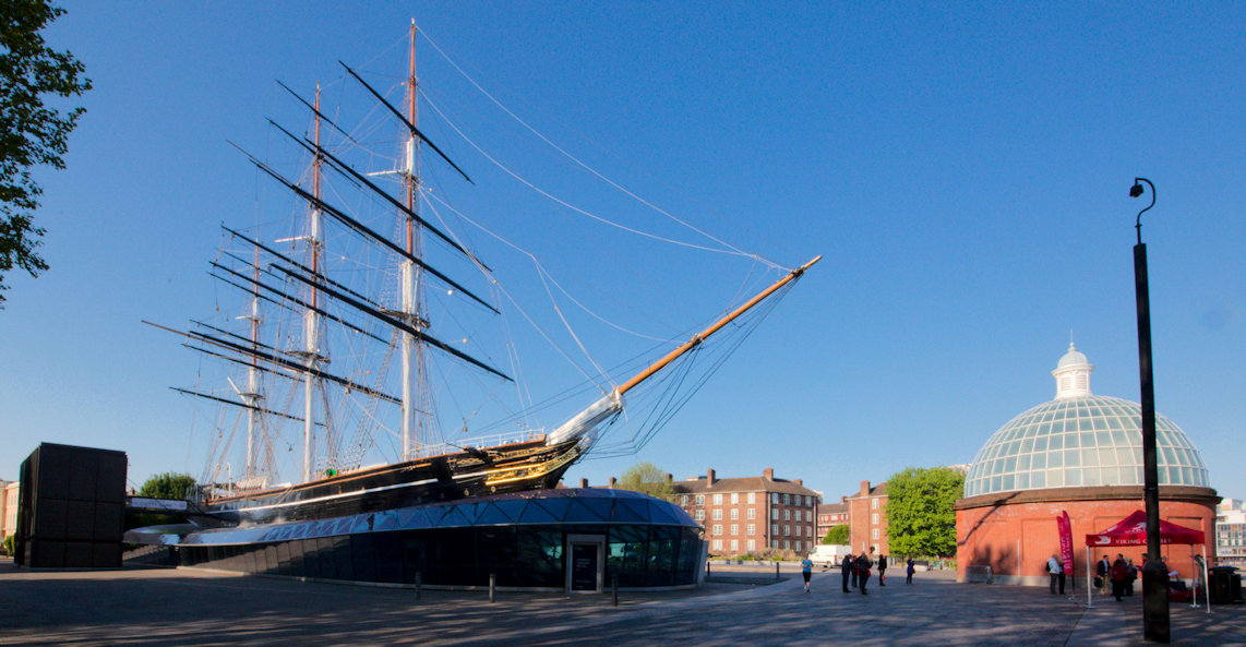
Cutty Sark and Gardens 29.1
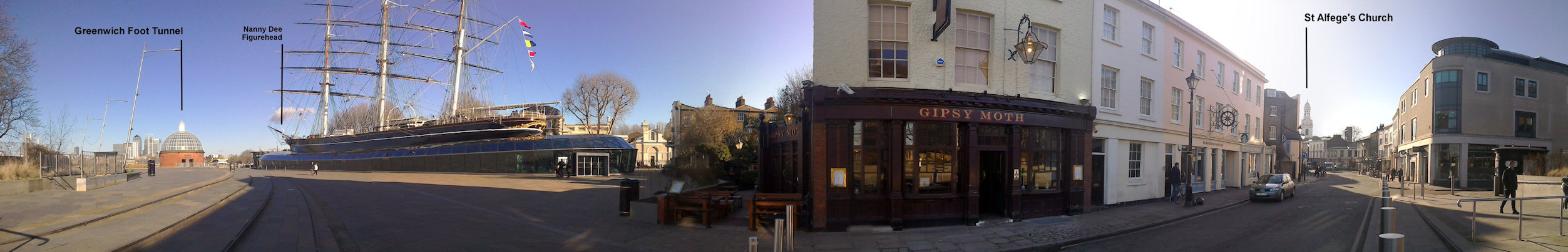
Cutty Sark and gardens
Cutty Sark Gardens is a popular open space right in the centre of Greenwich.
From this position facing the Cutty Sark you can see the entrance to the tunnel under the Thames to your left by the river, and the Gypsy Moth pub to your right.
In the summer and at Christmas there are often market stalls and other types of entertainment located here.
The Cutty Sark
Right in the centre, dominating the space, is the Cutty Sark, the most famous of the great Tea Clippers.
The ship has been fully restored and is held in a purpose built dry dock.
To preserve the ship's iron and oak hull it is no longer resting on its keel as it did originally when moved here, but instead it is suspended in the air, allowing the unique opportunity to walk right underneath her which you can see through the Windows.
If you walk around her, at the front you can see the figure head "Nanny Dee" wearing a "cutty sark" as well as taking in the masts and hull before returning to the entrance if you wish to go on board.
For more information about visiting the Cutty Sark here.
Back to the interactive map
Cutty Sark and Gardens - The History of the Cutty Sark 29.2
<History
The Cutty Sark was built in Scotland in 1869 in the twilight years of sail, when wind power was still faster than steam as long as the conditions were right and the boat was well designed.
Tea Clippers had to be fast as their job was to be the first to bring tea from the new harvest in India and China back to England where, as a luxury item, it would fetch the highest prices.
The ship was revolutionary in terms of its construction and had a unique hull shape that gave it the speed it needed.
Despite being a sailing ship the Cutty Sark was very much "Cutting Edge" technology at the time and the ship yard was bankrupted by the cost of building her.
Launched in 1870, the opening of the Suez Canal a year earlier had already given steam ships a 3000 mile short cut that sailing ships could not exploit.
By 1877 the Cutty Sark had completed her last voyage as a Tea Clipper.
In 1883 she was assigned to shipping wool from Australia to England, a task in which she also excelled, setting new speed records for the journey, but by 1895, even this was no longer viable and she became a regular cargo vessel renamed the Ferreira by her Portuguese owners.
In 1922 she was the last tea clipper left afloat and was returned to England and spent time as a tourist attraction and a naval training ship before finally arriving in Greenwich in 1954 having been saved from scrap by the public with the support of the Duke of Edinburgh.
By 2007 it became apparent that the ship's iron frame was being corroded by the high acidity of the oak and the Cutty Sark was effectively dismantled and rebuilt, during which a devastating fire caused by a faulty extractor fan almost finished her off, but on 25th April 2012 the Queen and Duke of Edinburgh reopened her to the public.
Not everyone likes the new design and it has the dubious honour of having won the title worst new building in Britain when it was completed.
Back to the interactive map
Cutty Sark and Gardens - Nanny Dee 29.3
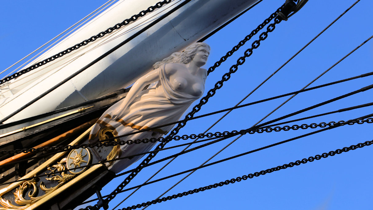
Nanny Dee
Nanny Dee is the white "figure head" on the bow of the ship.
Cutty Sark's name comes from a poem by the Scottish poet Robert Burns called Tam O'Shanter in which the hero is chased by witches, the fastest of which, Nanny Dee, is wearing a short night dress called a cutty sark:
"Her cutty-sark, o' Paisley harn,
That while a lassie she had worn,
In longitude tho' sorely scanty,
It was her best, and she was vauntie,
Ah! little ken'd thy reverend grannie,
That sark she coft for he wee Nannie,
Wi' twa pund Scots, ('twas a' her riches),
Wad ever grac'd a dance of witches!"
Back to the interactive map
St Alfege's Church Outside 30.1
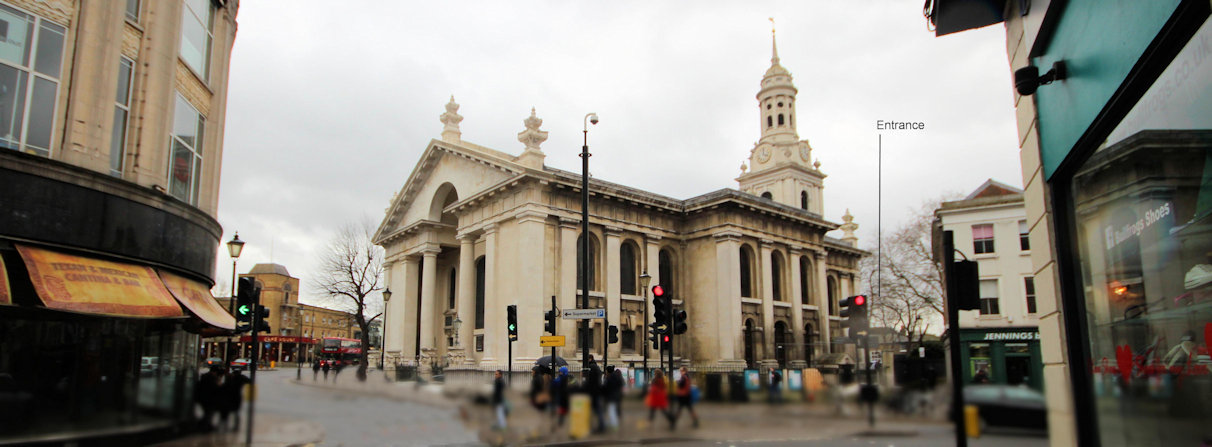
St Alfege's Church
Greenwich may not have a cathedral, but it does have a very beautiful and historic church.
It was completed in 1714 by Nicholas Hawksmoor, the protege of Sir Christopher Wren.
The current baroque building is the third church and replaced the medieval church built in 1290 in which Henry VIII was baptised in 1491.
This church unfortunately collapsed, an event which was not that uncommon at the time because of undermining of the foundations by over zealous grave diggers.
The original entrance is via the steps up to the large doors on the North side, just off Greenwich Church Street, but today you have to go past these doors and round the back to the church yard to find the entrance.
Back to the interactive map
St Alfege's Church Outside - Saint Alfege 30.2
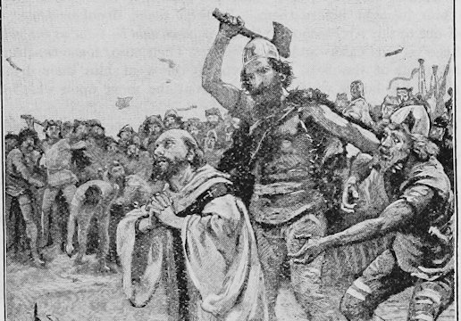
The Story of Saint Alfege
Over one thousand years ago in 1011, Alfege, the Archbishop of Canterbury, was betrayed by one of his own monks and captured by Vikings who had ransacked Canterbury and burned the cathedral to the ground.
He was brought back to the Greenwich marshes which had been established as the Viking's base for raiding London and Kent by their leader Thorkell the Tall.
Alfege was held to ransom, but steadfastly refused to negotiate with the Vikings as he did not want his people to pay for his release out of their own pockets.
After six months, at a feast on Easter Day, 19th April 1012 (now St Alfege's Day) the Vikings, demanding their gold, were incensed by his reply: "the gold I give you is the Word of God" and they clubbed him to death.
News of his death spread rapidly through Christendom together with reports of a miracle where an oar dipped in his blood had sprouted.
A church has stood on the site of his death ever since and he was canonised in 1078.
Back to the interactive map
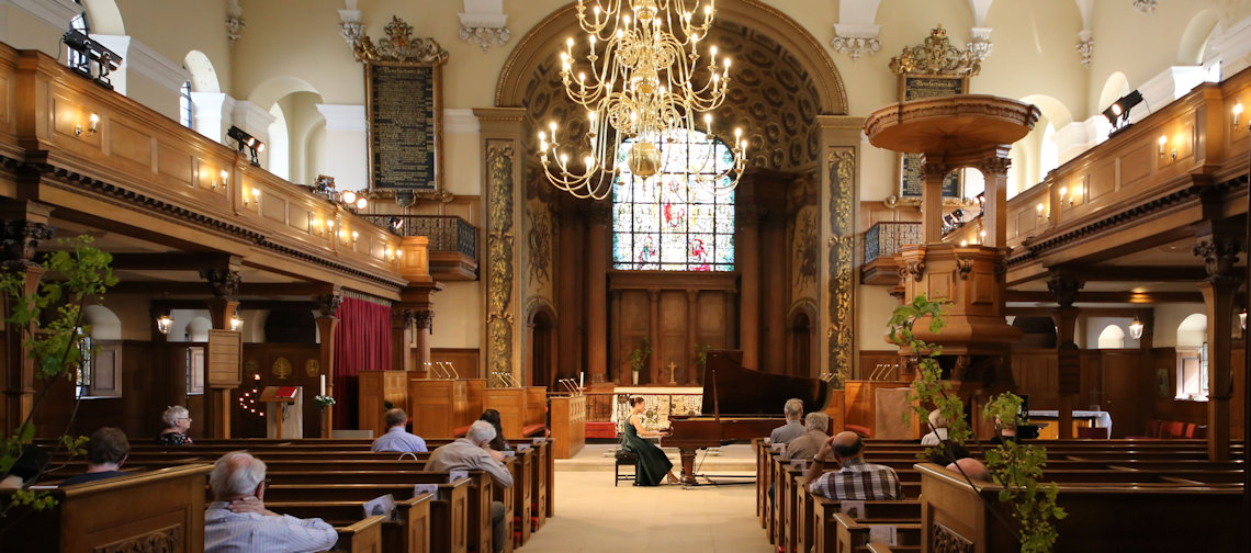
St Alfege's Church Inside 31.1
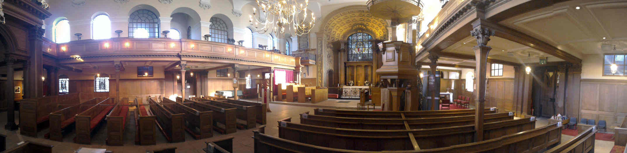
St Alfege's Church Inside
On entering the church take a chance to look around before walking towards the Altar.
On the right in the south west corner behind the baptism font, you will find an old organ console discovered when the main organ was refurbished in 1910.
It is believed that the octaves in the middle keyboard are taken from the tudor organ from the previous medieval church.
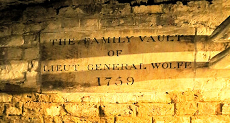
On the left of the aisle at the back is a brass plate in the floor indicating that General Wolfe's sealed vault is in the crypt below.
This plate is a copy of the one that is on his coffin.
General James Wolfe lived in Greenwich and was responsible for leading the English victory over the French in Canada resulting in the formation of the current Canadian State (see Wolfe's Statue).
Back to the interactive map
St Alfege's Church Inside - The Altar 31.2
The Altar
In the Chancel by the Altar you will see in the floor the words "He who dies for Justice dies for God" engraved on a slab, symbolically marking the place where St Alfege was martyred.
Either side, the columns and cornices are true to the original Hawksmoor design and include much of the original fine oak carving by Grinling Gibbons, a master carver famous for his fine work especially in St Paul's Cathedral and Windsor Castle (Note: the wood of the original carvings appears darker and are best seen in the trancepts).
If you look at the side of the stairs of the pulpit you will see one elaborately carved stair end with all the others plain.
This is an original Gibbons carving that was salvaged after the original pulpit was destroyed by a bomb.
Looking back to the Chancel, you will also see paintings by Sir James Thornhill which were uncovered by the restoration work (see Painted Hall).
The wrought ironwork railings of the upper floor are the original Hawksmoor decoration.
Back to the interactive map
St Alfege's Church Inside - The Crypt 31.3
The Crypt
Apart from Henry VIII, the church has had associations with several famous figures in British history that resided in Greenwich and chose to be buried here.
At the back of the church, as already observed, you will find a brass plate in the floor indicating that General Wolfe's sealed vault is in the crypt below.
Thomas Tallis, the celebrated composer of Choral music in the sixteenth century is known to have been interred here, but the whereabouts of his remains are unknown.
Little is known about his early years, but he progressed from being an organist to composing music, taking up posts at Cantebury Cathedral and the Royal Court where he wrote music for Henry VIII and Elizabeth I and had a house in Greenwich.
Sir John Julius Angerstein, credited with the creation of the pre-eminent insurance underwriter "Lloyds of London" and whose extensive art collection formed the basis for the establishment of the National Gallery is also buried in the Crypt.
He lived in Woodlands in East Greenwich, now known as Mycenae House.
Samuel Enderby, made his fortune from a whaling company he founded in 1773 which resulted in a shipping dynasty that lasted 150 years and was significant enough to get a mention in the novel Moby Dick.
In its final years the company ran a successful rope works at its large Enderby Wharf site which later manufactured the first transatlantic telegraph cable as the buildings were ideal for this purpose.
The church maintains strong ties with Canada because of General Wolfe, but also because of the lesser known Henry Kelsey, a 17th Century English fur trader, explorer, and sailor who played an important role in establishing the Hudson's Bay Company.
Kelsey was born in Greenwich 1667 and is the first recorded European to explore the Great Plains.
Back to the interactive map
St Alfege's Church Inside - Ceiling 31.4
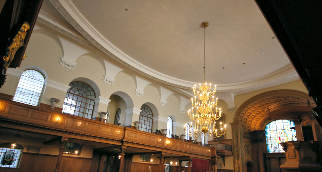
The Ceiling
The inside of the church is beautifully proportioned and the impressive oval shaped suspended ceiling was the largest unsupported ceiling in Europe when it was built.
Incendiary bombs dropped on the Church in 1941 set the roof ablaze and it collapsed into the nave destroying most of the interior, but leaving the walls and tower intact.
The church was carefully restored after the war and reopened in 1953 having stayed open through the intervening years through use of a temporary church within a church.
The plaster work was faithfully reproduced using traditional techniques, but the roof was reconstructed using modern lighter materials.
Back to the interactive map
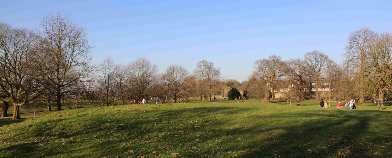
Wilderness View (West) 32.1

Deer Enclosure
Greenwich Park is the oldest London deer park, having been the home of red deer and fallow deer since they were introduced by Henry VIII in 1510 when he paid a certain Eustace Browne 13 pounds to stock the park.
The red deer are the larger animals with a reddish-brown coat while the fallow deer are smaller with a lighter brown coat with white spots.
If you cannot see any deer from here you can try the other wilderness viewpoint.
Originally the deer were free to roam around the entire park and if you do some roaming yourself you might stumble upon water troughs installed for their benefit.
Increasing visitors and road traffic resulted in them being constrained in what is now referred to as the Wilderness in 1927.
Today the 30 or so deer are carefully managed and you can view them from two areas through fences.
Deer park were important in the Tudor era because hunting was the sport of kings and the aristocracy and having a deer park was the ultimate status symbol of the time.
It was seen as good exercise and recommended by doctors, but was also a demonstration of skills in riding and weapon handling.
It is worth noting that hunting back then was a lot quieter than it would be today as the crossbow was the weapon of choice.
Although guns were available and used in battle they were neither portable nor accurate enough for hunting.
Back to the interactive map
View from One Tree Hill 33.1
One Tree Hill
Somewhat off the normal tourist trail, One Tree Hill is a lot less busy than the Observatory and does give you a very different perspective of the park.
To the east you can see Vanbrugh Castle and to the west there is probably the best view of the Royal Observatory you can get.
Looking north across the river with the boating lake in the foreground, you have a clearer view of central London, including the London Eye.
Back to the interactive map
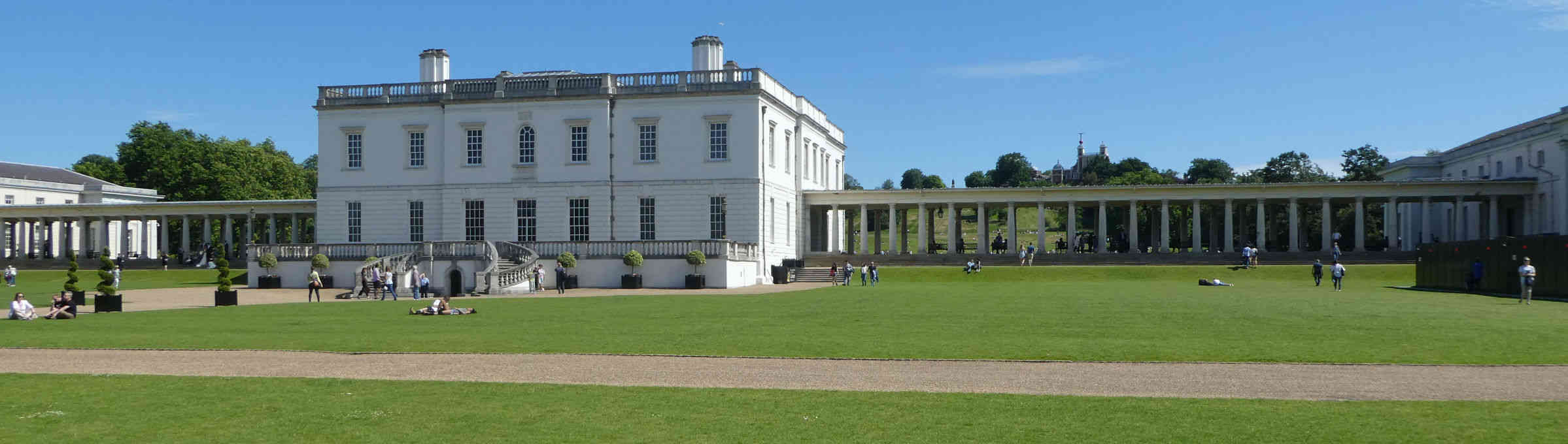
National Maritime Museum Main Entrance 34.1
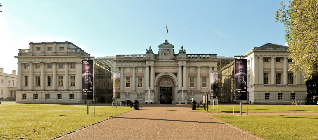
National Maritime Museum
The National Maritime Museum is the largest museum of its kind in the world and has exhibits about all aspects of the history of seafaring.
Since the sea has played such a pivitol role in British History, it covers many important historical events so you don't need to be a fan of ships and the sea to appreciate its impressive collections.
It is housed in buildings that belonged to the Royal Hospital School founded in 1712 as part of the Hospital.
When the school moved to new buildings the Museum was created over the course of 10 years, opening in 1937.
Since then the building has been extensively modernised to provide additional space and house multiple galleries suitable for all ages.
The museum has two entrances, this is the main one, a second entrance opens into the park and has a cafe next to it.
For more information on the Maritime Museum visit their website: Maritime Museum
Back to the interactive map
Queen Elizabeth Tree 35.1
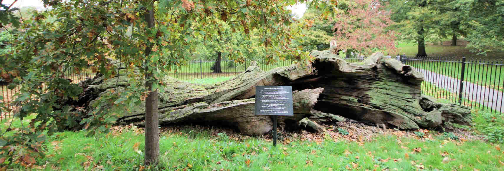
Queen Elizabeth's Oak
An acorn took root sometime in the twelfth century well before 1433 when the park was first enclosed and over 500 years before it was landscaped in 1660.
By then, the ancient oak tree was impressive enough to be spared the axe during the extensive replanting and was instead incorporated as a significant feature.
Although it died around 1880, it was so substantial that it remained standing until 1991 when it was finally toppled by hurricane force winds.
A new oak has been planted in front of the remains of the original.
The name of the tree derives from the story that during her walks in the park the young Queen Elizabeth took refreshments inside the tree, which was hollow and afforded some protection from the elements.
According to some it was later turned into a lock-up for transgressors of park rules through the fitting of a door.
There is also a story that Elizabeth's parents, Henry VIII and Anne Boleyn, danced around this very tree during their courtship.
The Oak is the national tree of England, and this long dead tree is testament to the economic and military importance of the oak forests that once covered the south of England.
These forests played their part in making the area around Greenwich a key location for the construction of ships and hence supported the development of the first major naval power in the world.
Back to the interactive map
Queen Elizabeth Tree - Conduit Cover 35.2
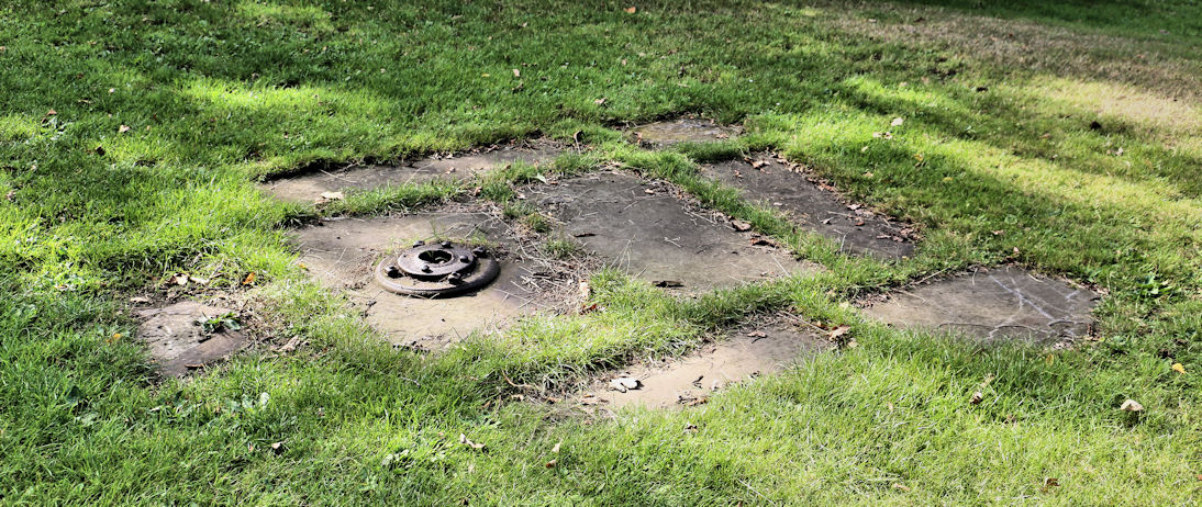
Queen's Oak Conduit Cover
South of the remains of the tree you will see some slabs and an iron seal indicating the presence of one of the two known water conduits under the park.
This one is referred to as the One Tree Hill conduit because it terminates at the foot of that hill in a Conduit Head designed by Nicholas Hawksmoor.
Back to the interactive map
Queen's House Haha Gate 36.1
Queen's House Haha
A haha is a ditch and wall frequently used in mansions that face onto land containing animals.
Rather than build a wall to keep the animals off the lawns that would then obscure the view, the wall is sunk into a ditch so that when the landscape is admired from the mansion, in this case the Loggia of the Queen's House, it appears as if there is no wall and the land just extends into park.
Back to the interactive map
Greenwich Market Food Court 37.1
Greenwich Market - Food
In the early 1800's Greenwich Market was mainly selling food and other household essentials.
This included both live animals and butchered meat and the much altered stables and slaughterhouse buildings are still standing near the new food area.
There was almost no regulation on the hundreds of private slaughterhouses in London at the time and the conditions would have been cruel, insanitary, and noisy.
It is very hard to imagine how different this area would have looked, sounded and felt at that time.
Continual lobbying from butchers meant that the government took no effective action to resolve the situation until 1890 when they finally obtained the power to close unhealthy slaughterhouses and could force butchers to use the new centralised abattoirs, the nearest of which was in Deptford.
Back to the interactive map
Greenwich Market North 38.1
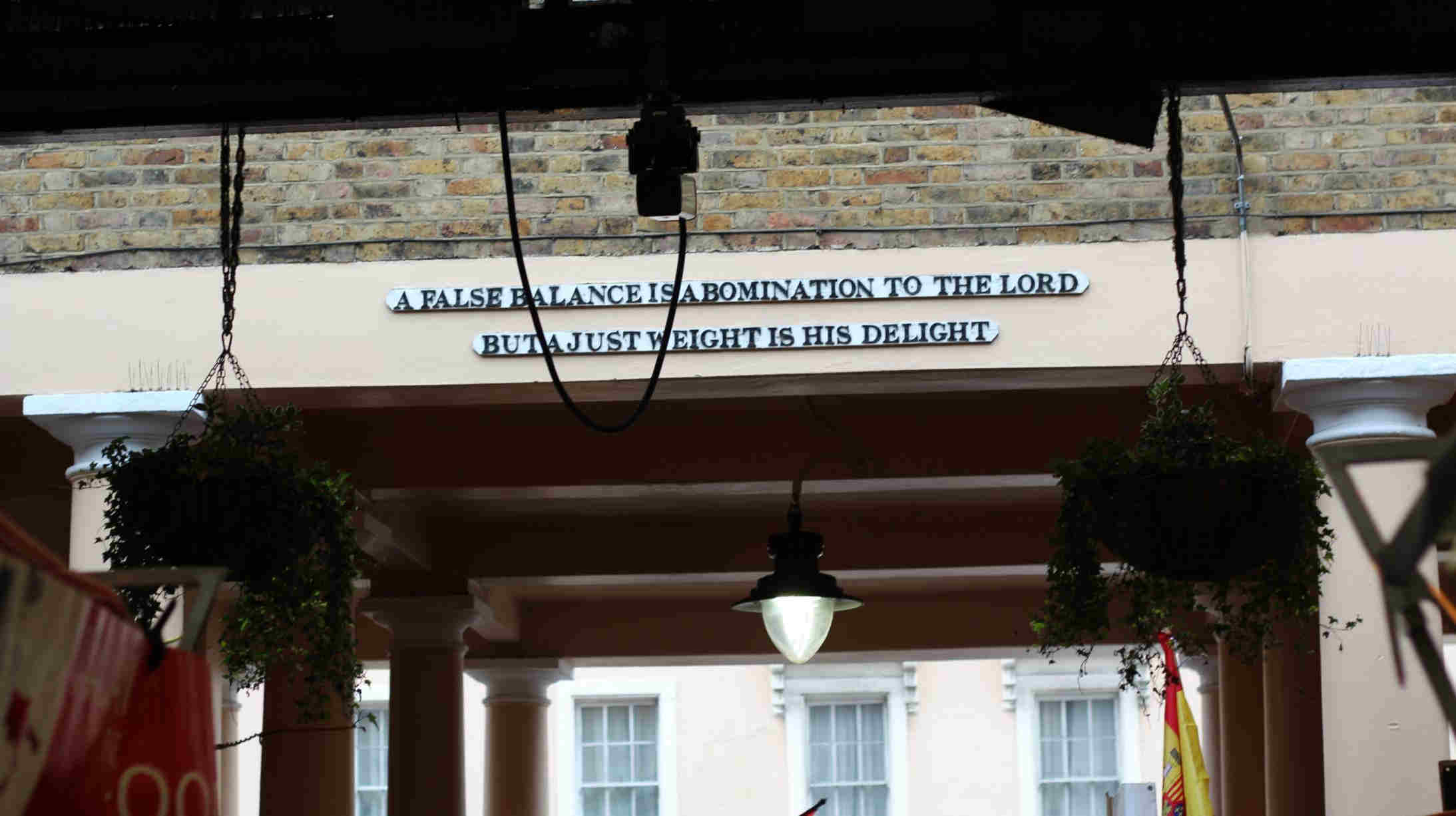
Greenwich Market - Admiral Hardy
During the nineteenth century the market was improved and when the Admiral Hardy pub built a small theatre by extending over the north entrance arch in 1845 the inscription "A false balance is an abomination to the Lord, but a just weight is his delight.
" was added.
By 1908 the timber roof had become dangerous and it was replaced by the steel roof that covers you today although this was extensively repaired in 2015.
If you don't like crowds, or want to see the buildings rather than shop then you should visit midweek when it is much quieter.
You can find more details on their website: Greenwich Market
Back to the interactive map
Naval College West Entrance 39.1
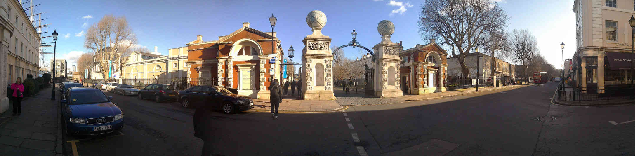
Old Royal Naval College, West Gate
The west gate is the most imposing entrance to the Naval College with its two pillars topped by globes.
These commemorate the circumnavigation of the world by George Anson in 1744 as part of a naval mission to attack the Spanish in South America.
His vast personal fortune was obtained from the 'spoils of war' when he collected 1,313,843 pieces of eight from the capture of a Spanish galleon.
It is worth noting that two thirds of his crew died during this voyage, mainly from scurvy.
Such a death rate may seem incredible today, but this was not uncommon in the navy at that time, where the importance of fresh food in the diet was not understood.
It was this high death rate that meant that the navy tended to be populated with poor foreigners picked up in the last harbour, or even drunks "press ganged" into service against their will.
Back to the interactive map
Flower Garden 40.1
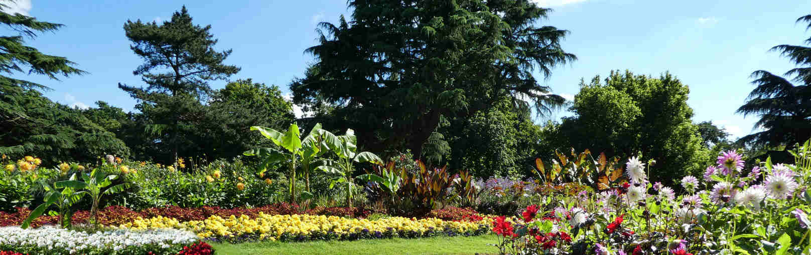
The Flower Garden
The Royal Parks keep this garden in top shape with seasonal plantings so that outside of the winter months you are always greeted with a huge splash of colour.
It is also a nice place for young children to play as no dogs are allowed and the trees make good hiding places.
You can also go and see the deer.
History
Originally this whole area was was part of the wilderness inhabited by the deer, but in 1854 work began to create an ornamental garden, including the construction of nurseries to provide the plant stock which are still working and located in the south east corner.
What plants there were had to be protected from the deer by their own individual fences until the deer were fenced off from the rest of the park as they are today.
The planting continued until 1900 at which point the gardens were relatively unique for a public park.
"The Gardener's Chronicle" said in 1925: "one would imagine oneself to be in the midst of a beautiful garden attached to some stately home", and that is undoubtedly still true today.
Back to the interactive map
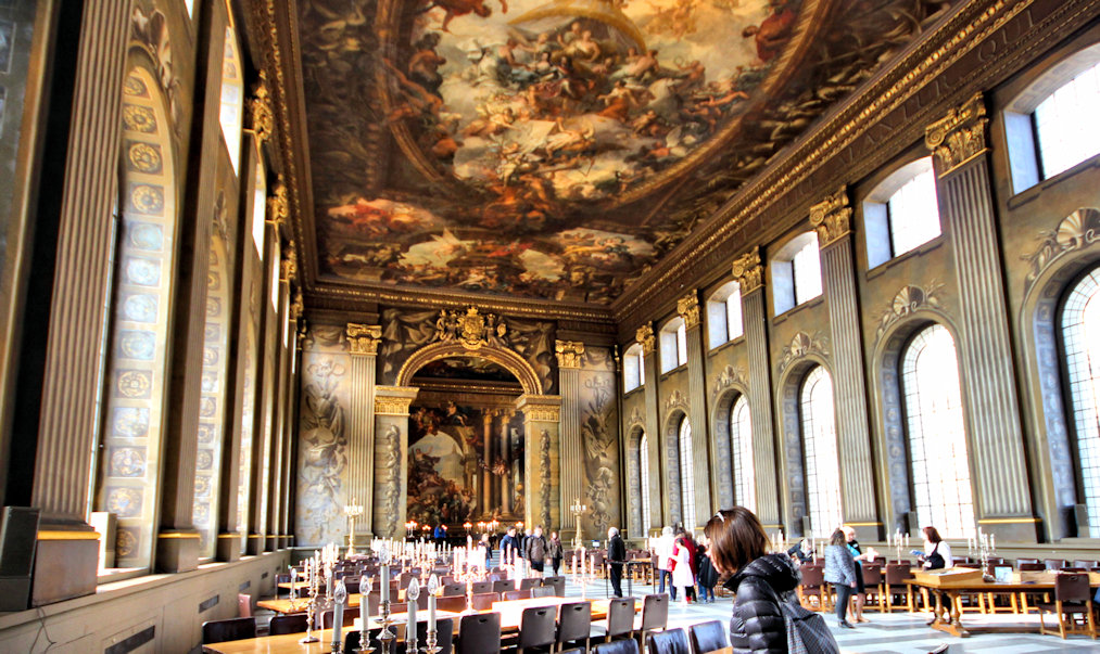
Naval College Painted Hall 41.1
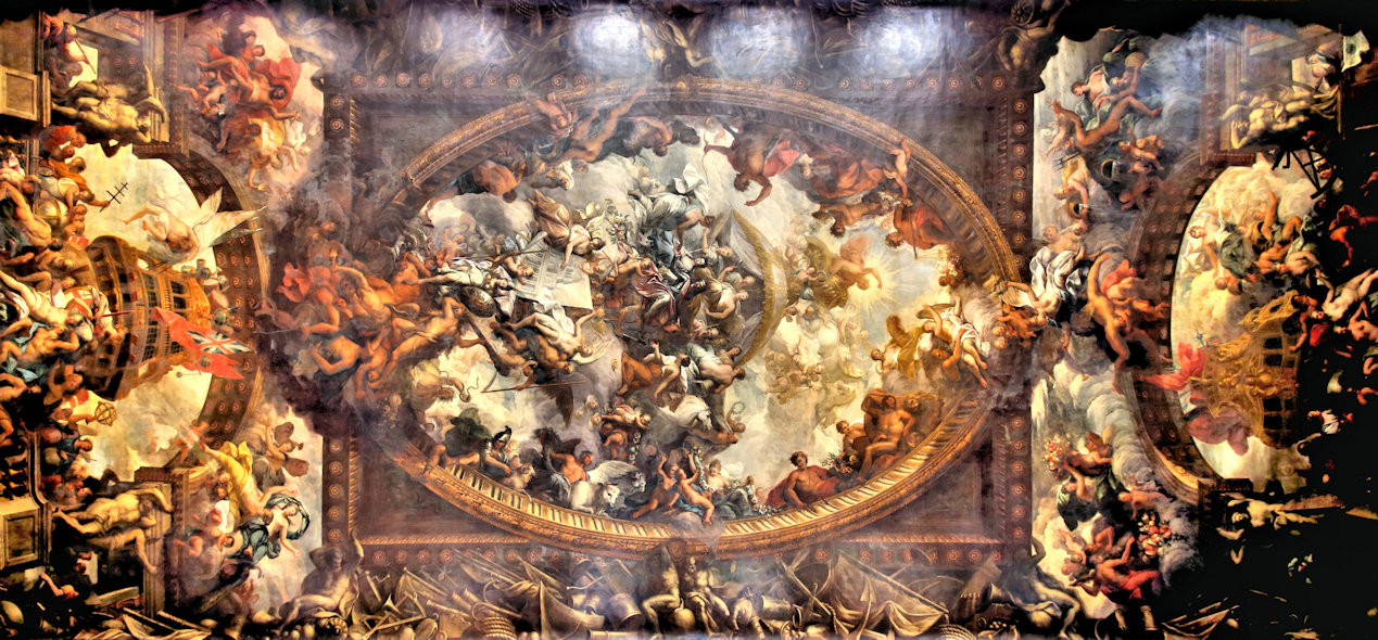
The Painted Hall
The Painted Hall houses one of the great painted ceilings of the world.
The hall was designed by Sir Christopher Wren and his assistant Nicholas Hawksmoor and when completed was painted by Sir James Thornhill over a further 19 years between 1707 and 1726.
For more information visit the ORNC website
Back to the interactive map
Naval College Painted Hall - Painted Hall 41.2
Inside the Painted Hall
Originally designed as the dining hall for the hospital residents, in 1824 it was decided that the hall was far too grand for that and this function was moved downstairs to the under croft.
The hall became a naval art gallery and served this purpose until 1937 when the Maritime Museum was opened and could house the collection.
When the hospital was converted into the Naval College in 1869 the hall was returned to its original purpose and used for both officers dining and banquets.
Its most sombre moment was in January 1806, being the place where Lord Nelson's body was held in state as part of one of the most impressive funerals in British history which included a full naval escort for his body up the Thames.
There is a plaque in the floor marking where the coffin stood.
Back to the interactive map
Naval College Painted Hall - The Main Painting 41.3
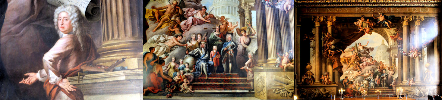
The Main Painting
Although somewhat overshadowed by the magnificent ceiling, the painting at the far end of the hall is no less impressive showing the Hannoverian King George I resting his elbow on a globe depicting his control over the world while receiving his sceptre from the mythical character "Peace".
The scales of justice are held just above his head.
Although born in Germany, George became King, because Queen Anne had died without an heir and he was next in line by birth.
The Latin inscription at the top of the painting "IAM NOVA PROGENESIS CAELO" means "now a new lineage is sent down from heaven".
He is surrounded by his family in a classical setting with his son, destined to be George II, standing to his left and his elderly mother, the Electress Sofia of Hannover, seated behind them.
His wife, Sophia Dorothea of Celle, is not shown as they were estranged, but directly behind him is his daughter in law the Princess of Wales next to her daughter who is holding a mirror.
His grandchildren are at his feet on the stairs.
In the background is the dome of Saint Paul's cathedral, acknowledging Sir Christopher Wrens best known architectural achievement.
Finally, at the bottom on the right, is a self portrait of James Thornhill beckoning you to admire his work.
There is a popular story that during the painting Thornhill never felt that his efforts were adequately appreciated, especially financially, and he is holding out his left hand apparently reminding parliament that he still needed to be paid appropriately for his work.
More likely he is adopting a typically pretentious pose of that era and perhaps thanking George I for his knighthood.
Back to the interactive map
Naval College Painted Hall - The Ceiling 41.4
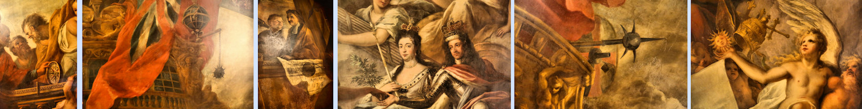
The Ceiling
The painting depicts peace and liberty defeating tyranny and tells many stories related to the monarchy and naval power, covering battles, conquests and even the work of the observatory through various historical or mythical scenes.
King William III can be seen centre stage with Queen Mary.
Behind them are the virtues.
On their right with her lambs, Peace hands William an olive branch while he in turn hands the red cap of liberty to Europa who is kneeling on his left.
Under William's feet, crouching with a broken sword is the defeated Louis XIV of France.
Apollo rides his chariot above them and below Architecture holds up Wren's design for the hospital, while on the right the naked figure of truth supported by time holds up the sun.
Around the inside of the oval frame, there are references to each of the four seasons while on the outside are the signs of the zodiac.
Around the main painting there are many references to the navy and naval technologies of the time.
In back left corner, the observatory is referenced by a picture of Flamsteed with his assistant by a telescope.
In front of him is a date refering to a famous total eclipse of 1715 over London which was accurately predicted by Edmond Halley to within a few minutes using Flamsteed's sun and moon data which was a major scientific breakthrough at the time and of which Halley said:
The like Eclipse having not for many ages been seen in the southern parts of Great Britain, I thought it not improper to give the public an account thereof, that the sudden darkness, wherein the stars will be visible about the sun, may give no surprise to the people, who would, if unadvertised, be apt to look upon it as ominous.
Hereby they will see that it is no more than the necessary result of the motions of the sun and moon, and, how well those are understood.
Back to the interactive map
Naval College Painted Hall - Skittle Alley 41.5
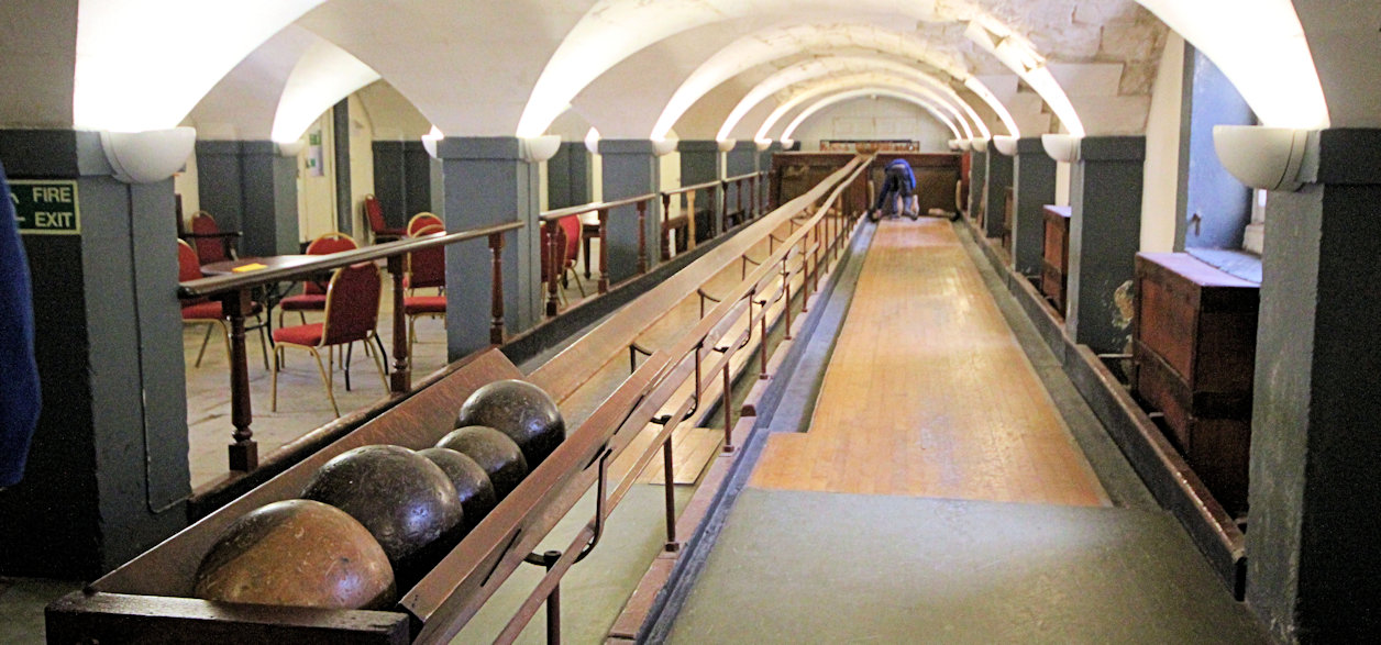
The Skittle Alley
If it is open, it is worth visiting the old skittle alley underneath the hall which was constructed as an amusement for the hospital patients and is an interesting contrast to modern ten pin bowling alleys.
Occasionally you even get a chance to have a go.
Back to the interactive map
Island Gardens 42.1
Island Gardens
If it was an inspiration for Canaletto, the great Venetian painter, then hopefully you will find the walk under the river is worth making to see Greenwich laid out before you with the swirling Thames in the foreground.
Canaletto probably painted this view in around 1752, to mark the completion of the Hospital buildings in 1751.
If you didn't come by boat then this, one of the great views in London, almost unchanged for 300 years, should be on your must do list.
Island Gardens were opened in 1895 and are on the tip of a peninsular called the Isle of Dogs, reputedly because Henry the VIII kept his hunting dogs kennelled here.
The western edge of the peninsular is known as Millwall.
Originally Marsh Wall, it was renamed after Dutch engineers built a number of Windmills along a wall to drain the Marshland, and later mill corn.
This part of London is surprisingly windy as anyone who has sat on the restaurant roof terraces by the pier will testify.
If you venture further North into Canary Wharf or take the DLR home, you will see the remains of the docks (the reason the foot tunnel was constructed) now providing attractive waterfronts to the office buildings.
Back to the interactive map
Greenwich Park - Millennium Walk 43.1
Millennium Walk
Built to celebrate the millennium, this tree lined avenue takes you directly from the maritime museum to the observatory.
Back to the interactive map
Queen's House and Interior 44.1
Inside the Queen's House
The entrance to the Queen's House today is at ground level between the stairs at the front of the house.
The Queen's House contains just a small part of the extensive and impressive art collection of the National Maritime Museum including the instantly recognisable Armada portrait of Elizabeth I, undoubtedly the highlight, along with Holbein's iconic representation of her father, the ageing Henry VIII.
As a result of the various uses of the building over the years, including hosting Olympics organisers in 2012, much of the interior of the building has been reconstructed, but all the restoration has been faithful to the original aims of Inigo Jones.
The most recent refurbishment was competed in 2016 and includes the beautiful ceiling of the great hall.
More details on the Queen's House can be found on their website.
Queen's House
Back to the interactive map
Queen's House and Interior - Great Hall 44.2
The Great Hall
Both outside, and inside, the building adheres to the strict rules of proportion and symmetry that Palladian architecture dictates.
This will have been fairly obvious on the outside, but is less so inside.
For example the Great Hall with its high ceiling, marble floor and central gallery, is actually a perfect cube with every side 12.
2m (40 feet).
The black and white marble floor is original and was laid in 1637 by Nicholas Stone and Gabriel Stacey according to the design of Indigo Jones.
The gallery which runs all around the hall suspended on oak cantilevered brackets typical of the period is also original, but has had to be extensively repaired and reinforced.
The gilded paintwork is largely original having been revealed after the removal of many layers of paint in 1925 and the ceiling mouldings would have been similar.
The ceiling in white and gold leaf is a new feature from the latest refurbishment and was created by Richard Wright following similar methods to the original artists.
White and gold were the colours of Henrietta Maria and the Great Hall was finished in these colours when it was occupied by her.
The ceiling originally displayed nine specially commissioned paintings by Orazio Gentileschi, but these were removed in 1708 and given to Sarah Churchill as a present.
They are now on the ceiling in Marlborough House in London.
Before the new ceiling was created photographic reproductions of the originals had been installed.
Back to the interactive map
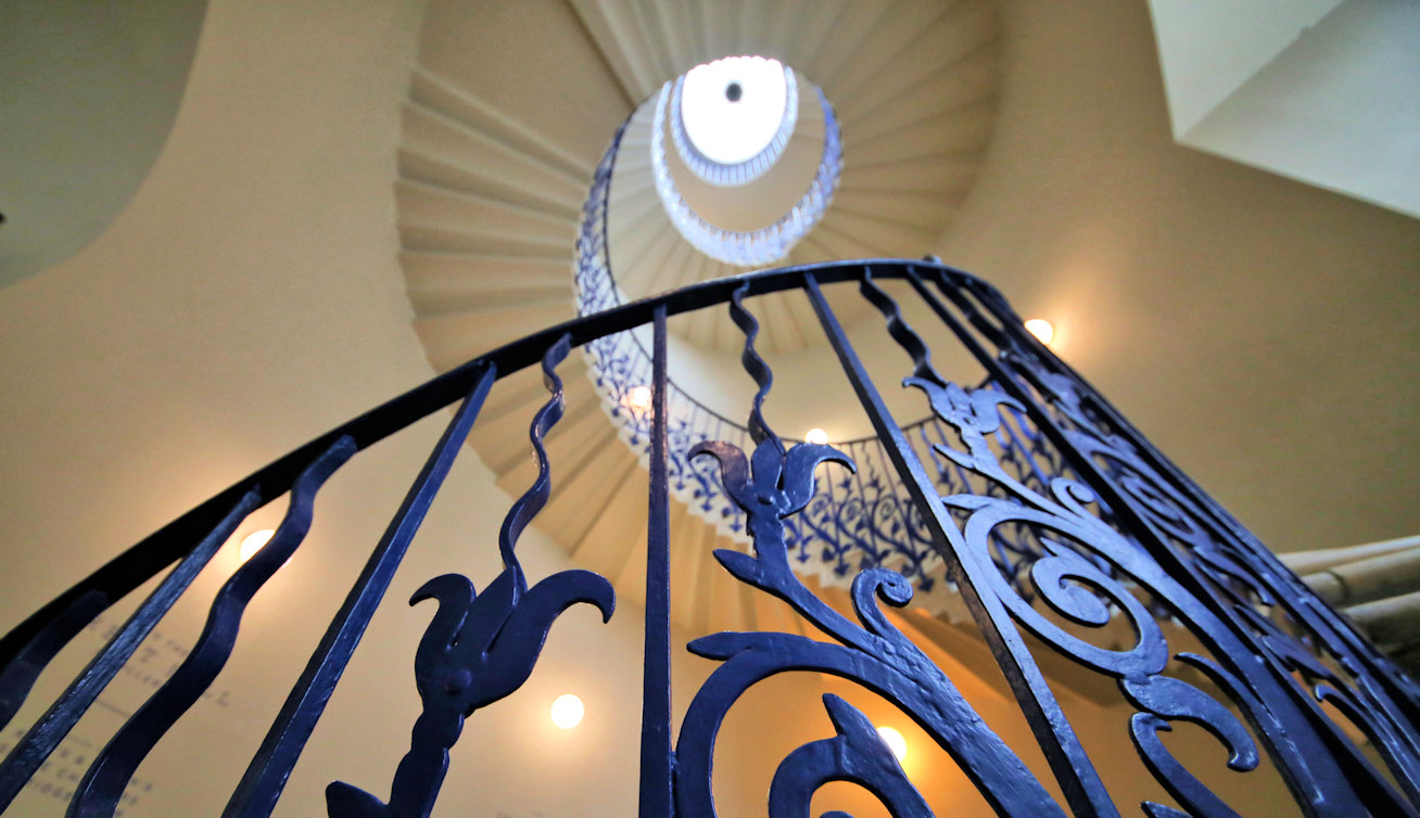
Queen's House and Interior - The Tulip Staircase 44.3
Tulip Staircase
The Tulip Staircase which can be accessed directly from the Great Hall was the first example of a cantilevered spiral staircase in England, a staircase with no central support, and is also an original feature.
It takes its name from its decorative blue iron work where each panel is filled with a graceful curving tulip design.
You can take this staircase up to the first floor and the visit the gallery and main exhibition rooms, but you will notice that they do continue up to the roof which is flat and leaded.
Once on the gallery you can get a really good impression of the cube and perspective of the Great Hall and also access the King's and Queens Presence Chambers.
The King's Presence Chamber has blue walls, the same colour as the Tulip Stairs, and the mouldings on the walls and ceiling are highlighted in gold leaf creating a very royal feel.
The room has had many modifications and only the pine ceiling decorations are original.
The Queen's Presence Chamber has rich red walls and contains the Armada Portrait which does dominate, but don't forget to look up at the ceiling painting.
It was painted in what is referred to as the Italian Grotesque style and is called "Aurora Dispersing the Shades of Night".
It is, however, not the original design, having been installed about 50 years after the house was completed and there is little knowledge of why or how it came to be replaced.
It is now believed to have been painted by the relatively obscure Edward Pierce Senior as it compares well to some of his other work and he is known to have been associated with Inigo Jones.
Back to the interactive map
Queen's House and Interior - Armada Portrait 44.4
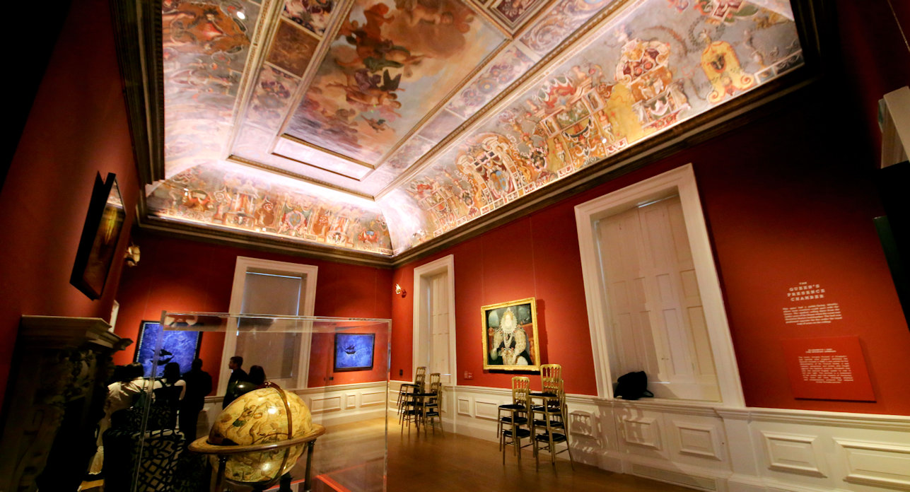
The Armada Portrait
The Armada Portrait celebrates the astonishing defeat of the Spanish Armada by the English navy under the leadership of Sir Francis Drake.
It is in many ways a piece of early propaganda, designed to send a clear message about the power of Elizabeth I after this great victory.
This is one of three remaining versions and the artist is unknown.
In the panels behind the queen you can see the English fleet in formation and the Spanish fleet floundering in a storm.
Spain and England had been enemies ever since Henry VIII divorced Catherine of Aragon.
When the Pope declared Elizabeth I an enemy of the Catholic Church, this was the perfect excuse for the devout King Phillip II to plan an invasion of England and the Armada was conceived.
120 ships under the leadership of the Duke of Medina Sidonia would sail through the English Channel to pick up 30,000 Spanish troops from the Netherlands.
The Spanish were confident that they would avoid or frighten off the English Fleet of only 60 ships, but they were spotted and harried around Portsmouth and made harbour in Calais waiting to hear that the troops in Holland were ready to embark.
The English sent six "fire ships" into the anchored Spanish Fleet causing so much panic that most of the ships cut anchor and the English were then able to engage the Spanish ships in the chaos.
The English victory was achieved through their tactic of sailing alongside the Spanish ships and unleashing a "broadside" where all the canon fired at the same time.
The English crews were able to repeatedly load and fire their canon, but the Spanish guns were not designed for this as they expected to fight using the traditional method of boarding and hand-to-hand combat.
The English always kept enough distance to prevent this.
The result was that the Spanish fleet was severely damaged and over 1000 men were killed or injured, around 10 times the casualties of the English.
Without anchors, strong winds forced the Spanish into the North Sea, and although they regrouped, neither the wind nor the demoralised Spanish captains were going to allow returning to Holland to complete the mission.
Comfortable that the threat was over, Queen Elizabeth made a speech to troops at the fort of Tilbury including the famous lines "I know I have the body of a weak, feeble woman; but I have the heart and stomach of a king, and of a king of England too".
She also commissioned this painting.
Unfortunately the only way home for the Armada was around Scotland and Ireland.
Damaged, without anchors, posessing only poor maps, and battered by storms, over half the fleet was lost along with three quarters of the original crews, turning a failure into a complete disaster.
Back to the interactive map
Queen's House and Interior - The Loggia 44.5
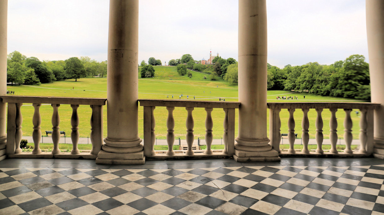
The Loggia
The Loggia, or long veranda, that overlooks the park is best seen from the outside when you enter the park.
Facing south, it would have been a delightful spot on a warm summer's day to relax and take in the view that had been carefully created by Andre Le Notre, landscape gardener to the French King Louise XIV.
Unlike now, the slope down from the observatory was an attractive planted terrace.
The Loggia was built longer than those typical of Palladio as Inigo Jones considered it to be one of the most attractive features of a house and invested a lot of time in making it a show piece of the building
The floor is of black and white marble squares in a diagonal pattern.
The Ionic capitals of the columns are equisitely carved and the ballustrades between them seem in perfectly harmony with the space.
Back to the interactive map
Naval College Chapel 45.1
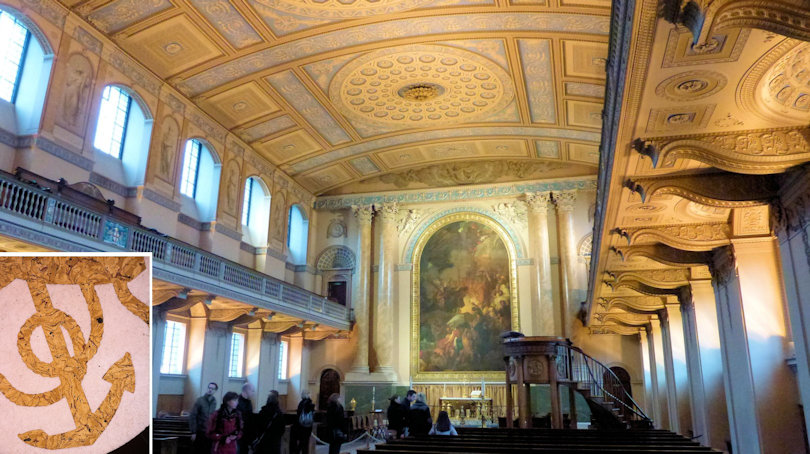
The Chapel
On the East side of the quadrangle is the Chapel of Saint Peter and Saint Paul, the last part of Greenwich Hospital to be completed, some twenty years after Wren's death in 1743.
Although from the outside it looks almost exactly the same as the Painted Hall, its inside is complete different and dates from a different era.
Having entered the vestibule and before ascending the steps and entering the chapel, it is worth noting the impressive Victorian memorial to the Franklin expedition on the right hand side of the steps in the alcove.
Back to the interactive map
Naval College Chapel - Inside 45.2
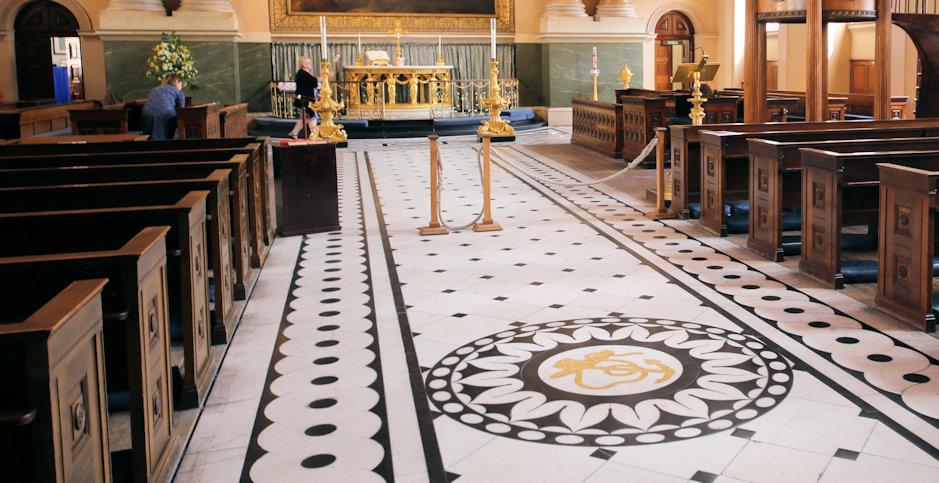
Inside the Chapel
When you enter the chapel you will immediately notice how different its decoration is from the rest of the naval college.
It is a stunning example of late eighteenth century internal design known as neoclassical rococo which was heavily influenced by classical Greek styles.
This contrast to the other parts of the hospital is the result of a fire in 1779 that gutted the original chapel requiring its interior to be completely rebuilt.
The renowned archaeologist and architect James "Athenian" Stuart was commissioned to carry out this work, but fell ill and recruited William Newton to assist him.
Stuart died in 1788, two years before the work was completed, and although it strongly bears his influence, it is primarily the design of Newton.
Although the spectacular plaster ceiling tends to grab your attention, look out for the decorative floor including an anchor inside a compass rose just before the altar.
The Corinthian columns at each end of the Chapel are not marble but cleverly disguised plaster and the carvings on the altar are made of Coade stone, an artificial stone which was ideal for creating fine decorations and the manufacture of which has long been a lost secret.
There is more information on these items in the discovery centre.
The organ above the entrance was installed by Samuel Green who was the leading builder of organs at that time.
He was a perfectionist and his instruments were famed for their mellow tone achieved through careful design of the pipes.
This example is the largest organ he built.
Beneath it, either side of the entrance, are busts of Admiral Hardy (of Nelson fame) and William IV who were both associated with the hospital.
Back to the interactive map
Naval College Chapel - Franklin Expedition 45.3

Franklin Expedition
The fate of the Franklin Expedition retains much mystery even today.
In 1845 the experienced Arctic explorer Sir John Franklin set sail with 128 men in two reinforced and well equipped ships on a three year voyage to locate and chart the north west passage.
This long dreamed of route through the arctic would significantly shorten the journey to the Pacific from Europe if it could be found.
Nothing was heard from Franklin's expedition for two years and in early 1848 pressure from his wife and Parliament forced the government to commission a search party and sponsor rewards for anyone able to locate him and his men.
Such was the fascination with the arctic at the time, that many other countries and even individuals sponsored searches.
Tragically, the efforts were futile and although some artefacts and bodies were found with help from the native Inuit population, it was not until 2014, 150 years later, that the wreck of one of his ships, HMS Erebus, was finally discovered by a systematic sonar search undertaken by Park Canada.
HMS Terror, the other ship, was discovered 2 years later.
The full story remains unknown, but there is enough evidence to show that the usual summer thaw which would have freed the boats from the ice did not take place for two seasons and their supplies began to run out.
Trapped in this icy desert, the deprivation that these poor men suffered can barely be imagined and is witnessed in their desperate attempts to escape and stay alive.
Back to the interactive map
Naval College Chapel - Painting 45.4
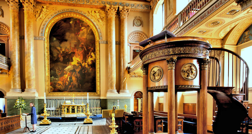
The Painting
The huge painting dominating the east end of the chapel is by the American artist Benjamin West who was "Painter to the Court" for George III and shows "The preservation of St Paul after shipwreck at Malta".
West's most famous painting is "The Death of General Wolfe" a copy of which was comissioned by George III and remains in the royal collection today.
A statue of General Wolfe can be found next to the observatory.
Back to the interactive map
Gloucester Circus 46.1
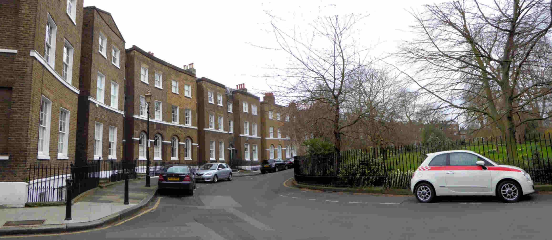
Gloucester Circus
The circus was built between 1791 and 1809 by Michael Searles and is Greenwich's contribution to the great crescent building bubble of that time, exemplified by Bath 50 years earlier.
You may wonder why only half the circus still exists and the answer is surprisingly that it was never actually completed.
When the circus was built it was a somewhat speculative development since Greenwich was not a sought after location for the wealthy at that time.
The building program was funded by sales and consequently the money to continue building was slow to materialise and after 18 years of piecemeal construction, development was halted with only the southern side completed.
Greenwich council filled the gap in the 1950's with the considerably less attractive housing that makes up the northern half.
Back to the interactive map
Ship in a bottle and National Maritime Museum 47.1
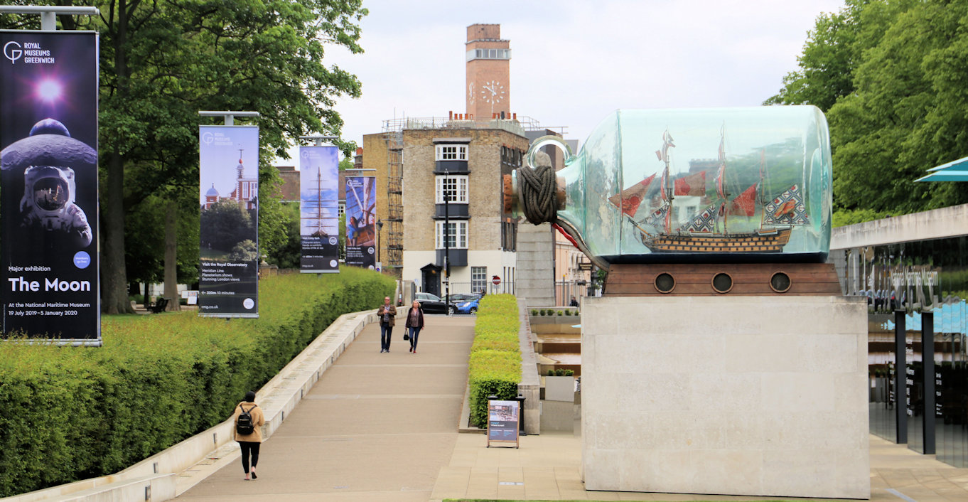
Ship in a bottle
Standing outside the newest part of the museum, the Sammy Ofer wing, you will see a large bottle with a ship in it.
This sculpture by British/Nigerian sculptor Yinka Shonibare is a scaled down replica of Nelson's flagship HMS Victory and was originally displayed on the empty fourth plinth in Trafalgar Square before finding this most suitable of homes after a large fund-raising initiative.
Back to the interactive map
Trinity Hospital 48.1
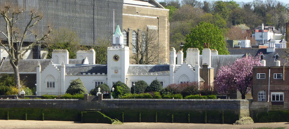
Trinity Hospital
Trinity Hospital was founded in 1613 by Henry Howard, Earl of Northampton making it the oldest building still standing in Greenwich although it was heavily modified in 1812, retaining its original character.
You have to peek through the gate as it is not open to the public because it still serves its original purpose of providing accommodation for the old and in-need.
Looming over the building on the east side is Greenwich Power Station which today is used to provide power for the London Underground.
Before you feel affronted about the insensitivity of building it here you should know that the land was originally owned by Trinity Hospital and sold for this purpose to raise funds.
Back to the interactive map
Trinity Hospital - Board Room 48.2
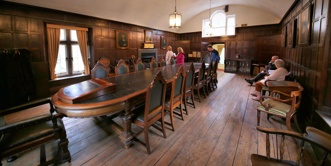
Board Room
As the oldest building in Greenwich the interior is very interesting with a private chapel and a board room which has been in continual use for the business of the charity since the hospital was built.
The Hospital is only open to the public on one weekend each year as part of the Open House program.
Open House
Back to the interactive map
Queen's House and Surroundings 49.1

Exterior of the Queen's House
Stand between the colonnades on what was the original route of the road from Greenwich to Woolwich.
To the north you can see the Naval College buildings.
Looking south you have the park laid out with the Royal Observatory prominent on the hill with its distinctive red time ball on a mast.
Adjoining the collonade is the Queen's House and and it can be seen how it was designed as a bridge with the road passing under it so that the royal occupants could easily and safely get from the old Palace of Placentia adjacent to the river to the enclosed deer park.
You should walk around the Queen's House to get a better perspective of its symetrical design, but the best view of the house is from the view point at the Observatory.
Back to the interactive map
Queen's House and Surroundings - History 49.2
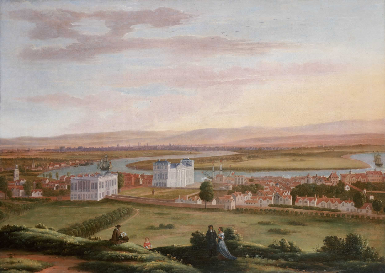
History of the Queen's House
The Queen's House was comissioned in 1615 by Queen Anne of Denmark after her husband King James I had given her the old palace of Placentia and its land, including the park.
Renowned for her extravagance, no expense was spared in allowing Inigo Jones, the architect, to create the first true classical building in England based on the designs of the Italian Palladio.
It was unfortunately left unfinished after Anne died and only finally completed 20 years later in 1635 by Charles I for his wife Queen Henrietta Maria.
Since it was faced with white rusticated stone at a time when most buildings were plain red brick, it was frequently referred to as the "White House".
Inside, Henrietta Maria, who was from the French royal family, furnished it lavishly in a comparable style to the palace of Versailles causing many to comment on its opulence.
Following the civil war and the execution of Charles I in 1649, Henrietta Maria was exiled to France and most of the contents of the house were sold off the same year.
The house itself was spared because Thomas Cromwell himself was said to have admired the building.
Later the house was occupied by the Ranger of Greenwich Park and Governor of Greenwich Hospital, which had been built on the site of the old Palace of Placentia.
In 1806 King George III gave the Queen's House to the school that had been created for the sons and daughters of seamen associated to the hospital.
Over the next few years the collonades were built and new wings either side were constructed as additional teaching space and dormitories.
The school was finally incorporated into the Royal Naval College in 1873 when the hospital was closed.
At this time it had a full size model of a corvette with tall masts called "Fame" situated in the lawns to the front.
This was used to train young men in the skills of tall ships, particularly the dangerous task of rigging.
The sunken part of the road under the house is the original height from when the house stood on its own.
It was excavated in 1930 when the National Maritime Museum was founded so that doors could be added to provide a more manageable entrance for visitors, but today the entrance has been moved back to the front of the house under the grand stairs.
Back to the interactive map
Observatory Yuri Gargarin Statue 50.1
Yuri Gagarin Statue
This statue of Yuri Gagarin, the first man in space, was presented to the British Council by the Russian Space Agency in 2011 to celebrate the 50th anniversary of his historical journey aboard the Vostok I rocket on 12 April 1961.
It was moved here from The Mall in 2013 and is an exact copy of the statue in Gagarin's home town of Lyubertsy (pronounced Loo-birt-see) which all cosmonauts traditionally visit before their first trip into space.
Back to the interactive map
Observatory Yuri Gargarin Statue - Gagarin's Career 50.2

Yuri Gagarin
Gargarin was the son of poor farm workers and joined the Soviet air force where he rose to senior lieutenant and became one of six pilots selected to train to be the first cosmonaut.
His good performance, and small stature (157cm) helped him become first choice to make history in the cramped Vostok I cockpit when it launched from Baikonur Cosmodrome.
After a spell of official visits around the world he went back to the air force and despite attempts to keep him on the ground as a hero of the Soviet Union, died when a training flight crashed in 1968.
Back to the interactive map
Fan Museum 51.1
The Fan Museum
The fan museum is an intimate museum dedicated to those folding hand powered cooling devices from the 19th Century and makes a surprisingly interesting diversion from all the mainstream attractions.
It is housed in a beautifully restored building dating back to 1721.
If you plan ahead you can book afternoon tea in the Orangery which you normally cannot enter and is a very enjoyable experience as the room is uniquely decorated.
Have a look at their website: Fan Museum
Back to the interactive map
Discovery Centre 52.1
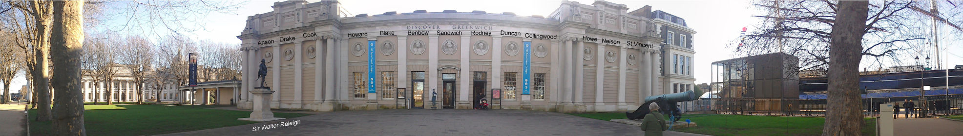
Greenwich Discovery Centre
Almost directly in front of the pier, and part of the Old Royal Naval College, is the Greenwich Discovery Centre which contains a museum about the Old Royal Naval College as well as general tourist information for Greenwich and the area.
As you approach the Discovery Centre it is worth taking a look at the exterior of the building which features classical columns and roundels depicting British admirals such as Drake, Cook and Nelson.
There is also a statue of Sir Walter Raleigh to the left of the entrance.
Favourite of Elizabeth I, he was a prolific explorer and key part of her war cabinet, overseeing the defeat of the Spanish Armada.
Also on your right, adjacent to the Discovery Centre you will find a bar, micro-brewery and restaurant in what was the original "Old Brewery" of the hospital.
Behind you on the right is a large obelisk, a memorial to the sailors and officers of the British Navy that died in the relatively obscure terratorial New Zealand wars against the Maori native population between 1845 and 1872.
Inside the exhibitions focus mainly on the Old Royal Naval College site, beginning with the original Tudor palace of Placentia where Henry VIII was born, through the construction of the Greenwich Hospital for injured Sailors, to the development of the Naval College and ultimately the main campus of Greenwich University.
You can check out the opening times and facilities of the information centre on their website.
Information Centre
Back to the interactive map
Discovery Centre - Pepys Building 52.2
Pepys Building
The Discovery Centre is located in what is known as the Pepys Building, named after the diarist, Samuel Pepys, who wrote extensively on London life during the seventeenth century.
As an administrator of the English Navy he spent a lot of time in Greenwich and Woolwich and they feature widely in his writing.
It was originally designed for use as squash courts for naval officers in 1874, but in 1905, it was refitted as the main mechanical engineering laboratory of the Royal Naval College.
Inside it is still possible to see the heavy beams and gantry crane that were installed to support this new use.
Back to the interactive map
Discovery Centre - Who was JASON 52.3
JASON
Shrouded in secrecy for many years was the surprising information that the Naval College had a small nuclear reactor in its grounds until 1996.
It was located in the basement of the King William building and was called JASON.
It was used to train officers and staff working on nuclear submarines.
It was removed completely by 1999 and the building declared clear of all radioactivity.
Back to the interactive map
The Royal Observatory 53.1
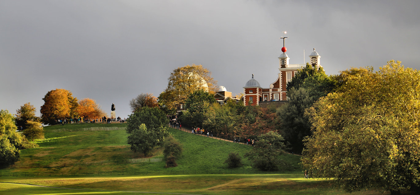
The Royal Observatory
A visit to the observatory takes you through a history of the astronomy carried out in Greenwich and also includes a fascinating account of the development of accurate timekeeping, before finishing in the Great Equatorial Telescope.
More information on the observatory can be found on their website.
Royal Observatory
Back to the interactive map
The Royal Observatory - Time Ball 53.2
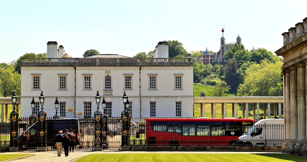
The Time Ball
The distinctive red time ball on the roof was only added in 1833 to allow shipping on the Thames to set their clocks accurately.
This is one of the few remaining working time balls in the world, and if you are here at 12:55pm you will see it rise to the top of the mast, and then fall at precisely 13:00 hours.
This was done so that ships moored on the Thames could adjust their navigational clocks to be as accurate as possible and was preferred to the more usual method of firing a canon since a visual signal was not delayed by the speed of sound.
Back to the interactive map
The Royal Observatory - Telescopes 53.3
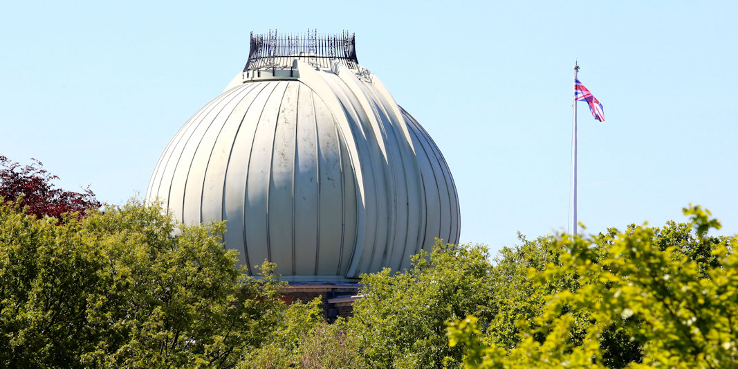
The Telescopes
During its lifetime as a working observatory the telescopes were replaced several times, and since the position of the telescope was the reference position for the meridian line, this was moved accordingly, its last and current location being based on the Airy Transit Circle which was used from 1851 to 1930.
The Great Equatorial Telescope with its opening roof is probably the most obviously astronomical building in the campus and was completed in 1893.
It is still the largest of its kind in Britain although no longer used for scientific purposes.
Back to the interactive map
The Royal Observatory - History 53.4
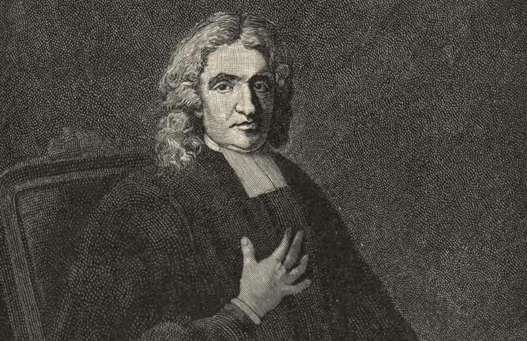
History of the Observatory
Commissioned by Charles II in 1675 during his extensive remodelling of the park, this unique building is iconic of Greenwich.
It is also known as Flamsteed House, as it was constructed for the first Astronomer Royal, John Flamsteed, both as his work place and his home.
It was designed by Sir Christopher Wren, more famously known as the builder of St Paul's Cathedral.
Wren had started out in life as an Astronomer and this explains how well suited the design is to the purpose of astronomy, with the tall windows and wide views from the impressive octagon room.
Not surprisingly, considering its position and view over the Thames, it was built on the site of the former castle tower constructed by Humphrey Duke of Gloucester when he inherited and enclosed the park in 1433, a castle that was not dissimilar in outward appearance to Vanbrugh Castle today.
As Charles II was always short of money, Wren had to make use of the old castle foundations and build with reclaimed brick and stone from the fort at Tilbury that was being repaired.
Despite these limitations he still managed to create the beautiful building we see now.
Back to the interactive map
Greenwich Market South 54.1
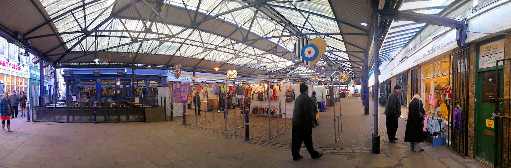
Greenwich Market
South London's answer to Camden Lock has a history dating back over 300 years when Greenwich Hospital (then housed in the buildings that now make up the Royal Naval College) was granted a thousand year royal charter to hold a market on the surrounding streets outside the West Gate.
In the early 19th century the market had become so popular that it was causing congestion on the surrounding roads and so it was moved to its current position and the stalls were covered over with a roof.
By 1980 the traditional grocery market was hardly used as supermarkets were taking all the trade.
Since it was not making any revenue for its owners, the charity "Commissioners of Greenwich Hospital", there was an urgent need to find a solution which would increase their revenue, but also be of benefit to central Greenwich, most of which they own.
In 1985 they relaunched the market as a craft market and the centre of Greenwich has not looked back since with antiques and other vendors growing up in the vicinity.
Greenwich Market has recently been modernised, but retains its traditional and intimate mix of Georgian and Victorian character.
You can find more details on their website Greenwich Market
Back to the interactive map
St Mary's Gate 55.1
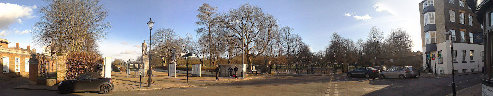
St Mary's Gate
St Mary's Gate is the main entrance to Greenwich Park and is quickly reached from the town centre and covered market.
It is normally closed to traffic, but during the rush-hour cars can travel through here to get to Blackheath.
The park has not always been able to be accessed by the public.
It was originally a royal deer park and only opened up to certain members of the local population in the 18th century.
One of the big attractions of the Greenwich Fair was that while it was on the park was open to all, but in 1830 George VI declared it a public park and today it remains open as one of the Royal Parks of London.
The gate takes its name from the neoclassical St Mary's Church which was once an imposing building on the east side of the gate.
St Mary's Church was built in 1823 to relieve crowding at St Alfege's and looked very much like a smaller version of its older neighbour.
The church was sited in the space where the statue of King William IV is now located and the old Woolwich road that ran under the Queen's house was blocked by its construction and diverted to its current route.
The church was closed and demolished in 1936 when the Maritime Museum opened as church going had declined and it no longer had enough parishioners to keep it open.
Back to the interactive map
St Mary's Gate - Statue of William IV 55.2
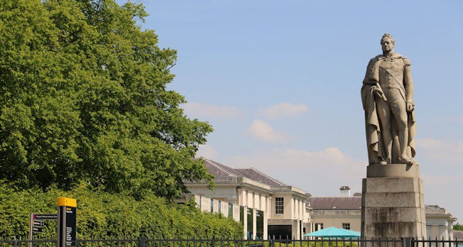
William IV Statue
The statue shows the king in the uniform of the Lord High Admiral.
It is carved in Scottish granite and was London's first statue to be carved in this difficult stone causing numerous challenges for the sculptor Samuel Nixon.
It is very fitting that his statue is here in Greenwich as William IV was known as the Sailor King.
Born in 1765, the third son of George III he entered the navy in 1779, aged 14, and assumed his first command at 20.
He was good friends with the young Nelson for whom he was best man.
The statue was originally unveiled in 1844 on the north side of London Bridge, but following road modifications it was taken to the National Maritime Museum at Greenwich and re-erected where it stands today shortly after the church was demolished.
Back to the interactive map
Parakeets 56.1
Was that a Parrot?
Near here you will see a water fountain, and around the corner a water trough, one of many tell tale signs of the water conduits that exist under the park and a throw back to when the deer were free to wander here.
As you start walking up the hill into a more wooded area don't be too suprised if you think you've seen or heard a Parrot in one of the trees, you probably have!
Greenwich Park has a thriving colony of bright green Rose-ringed parakeets, a bird that originates from South Asia, predominately India, and is a very common pet.
They are also clearly experienced escapologists!
Although they usually live in the tropics, the rose-ringed parakeet is also common in the foothills of the Himalayas and is, therefore, perfectly capable of over-wintering in Britain.
They also thrive in urban spaces and tend to stay in localised colonies which is why they are generally found concentrated in one place, like here.
Back to the interactive map
Play Ground 57.1
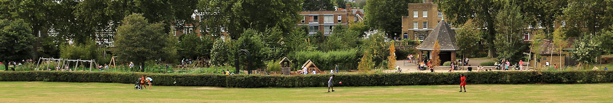
Play Ground
If you have young children then they will thank you for bringing them here.
The Royal Parks have invested a lot of money to make this one of the best play areas in London.
Back to the interactive map
Naval College Centre 58.1

The Painted Hall and Chapel
Either side of you are the two main buildings of the Naval College, the Painted Hall and the Chapel, both outstanding in their own right.
This courtyard between the Painted Hall and Chapel may feel familiar since this is one of the most popular film locations in the world, having featured in over eighty films, including Les Miserables, Skyfall and the Dark Knight Rises.
Today the buildings are part of the main campus of Greenwich University and the college is again busy.
As one of its departments is the Trinity College of Music, you may have a musical accompaniment as you wander around.
If you want to know more about the history of the Old Royal Naval College and missed the exhibits in the Discovery Centre then pop back and have a look.
You can drop in at the College Brewery too for a coffee or something stronger.
Back to the interactive map
Naval College Centre - History 58.2
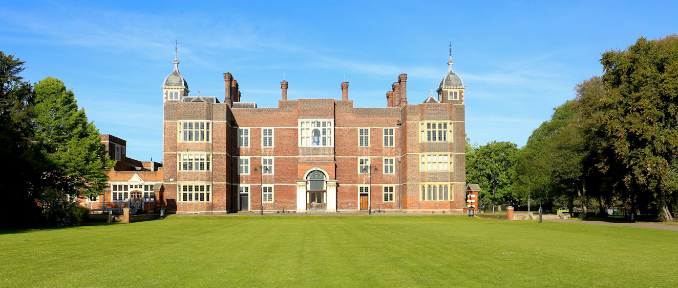
History of the Naval College
The first significant building to occupy this site was the Royal Palace of Placentia.
Placentia looked very different to the current buildings as it was primarily built of red brick and similar in style to Charlton Palace (shown above).
It had been built by Humphrey, Duke of Gloucester in 1443, and included the land that makes up the park.
Humphrey was the younger brother of Henry V and fought with him at Agincourt.
He also ran the country as Lord Protector while Henry VI was too young to take on the duty of King
Henry VII was the first King to declare the palace his favourite and soon after his coronation in 1485 went about restoring and extending the buildings.
His son Henry VIII was born here as was his grand daughter Elizabeth I, both of whom loved Greenwich.
Unlike the nearby Charlton and Eltham palaces, Placentia did not survive and the only remaining parts of it are the foundations.
The best preserved of these are in the undercroft of the north east building (containing the chapel) and once housed a small museum.
By 1694 it had been completely demolished and instructions had been given to build Greenwich Hospital by Mary II, Queen of William III, who had been deeply moved by the sight of wounded sailors returning from a battle.
It is this building that we see today, completed around 1712 with the Painted Hall and Chapel dating back to this time.
By 1869 the unusually peaceful coexistence of European nations had left the hospital almost empty and so it was closed and converted into a training facility for the Royal Navy, becoming the Royal Naval College as it is still referred to today with the addition of the prefix "Old".
Back to the interactive map
Observatory Planetarium 59.1
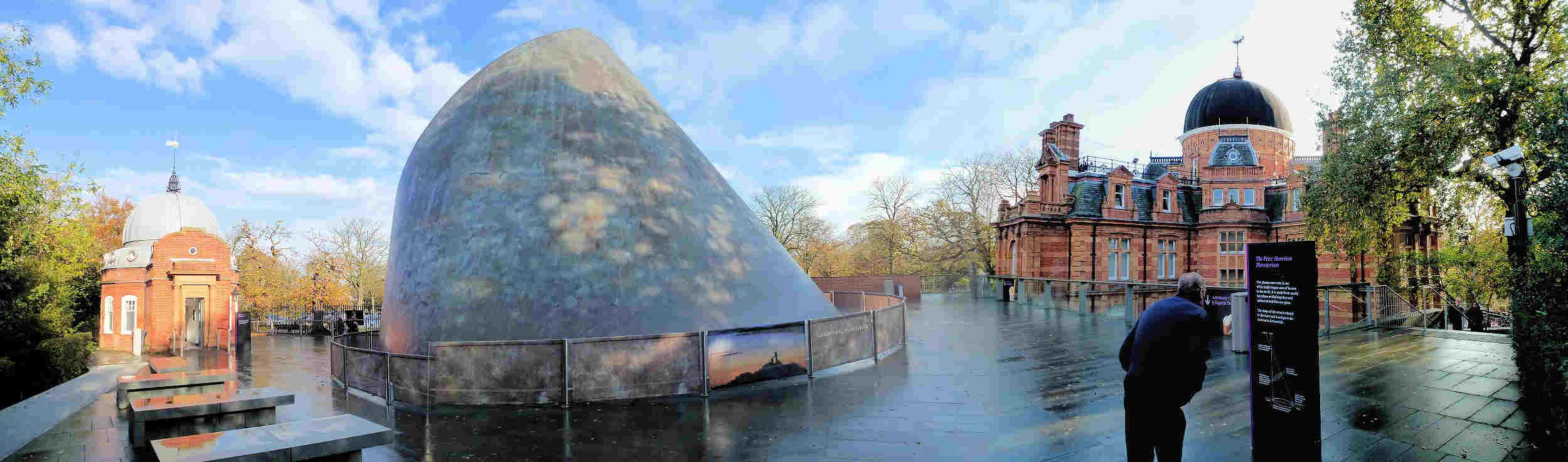
Planetarium and South Building
South of the main observatory can be found the "South Building" which houses London's only planetarium and several astronomy exhibitions.
By the Victorian age astronomy had become more about scientific discovery than navigation and the New Physical Observatory, as it was originally named, was completed in 1894 to provide additional working space.
Like many Victorian buildings it is highly decorated, but unusually it is finished in terracotta with various inscriptions including the names of the resident astronomers.
Between the South Building and the main observatory is the award winning roof of the planetarium which juts out of the ground dramatically.
You will also find the quirky Altazimuth Pavilion designed to house a new telescope that could point in directions other than the main meridian.
Unfortunately this telescope was not very successful and so was dismantled in the 1930's.
The pavilion now houses a small exhibition on solar astronomy and a new telescope has been installed upstairs called the Annie Maunder Astrographical Telescope specifically designed for astrophotography.
This area is only open on special occasions.
More details can be found on the website.
Royal Observatory
Back to the interactive map
Herb Garden 60.1
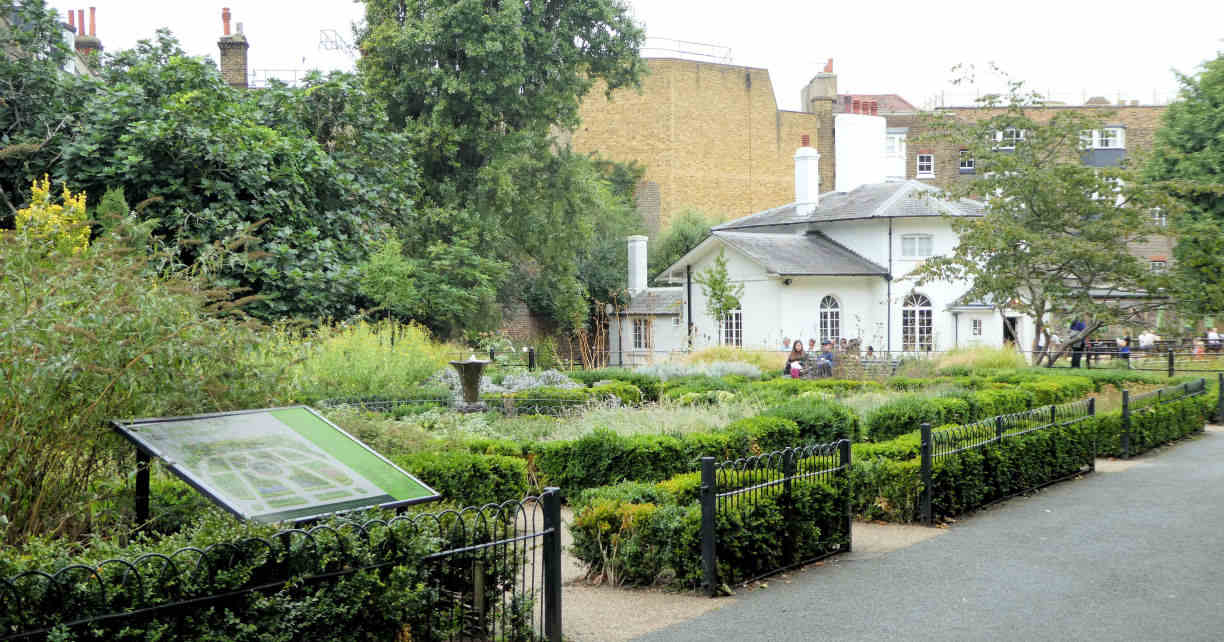
The Herb Garden
This small garden is actually pretty large as herb gardens go and was established in 1969.
It has been remodelled a few times since then, most recently to celebrate the millennium.
It is a good place to take a break with its fountain and herb beds filled with familiar aromas.
Back to the interactive map
Wolfe's Statue 61.1
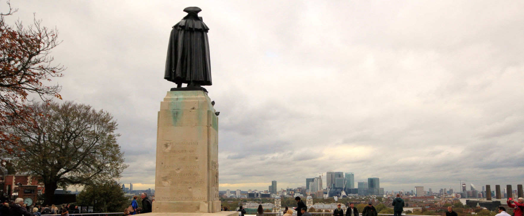
Wolfe
Erected in 1930 as a gift from the Canadian people, this man of bronze has possibly the best permanent view in London.
Major General James Wolfe was responsible for the British victory over the French at the Battle of Quebec in Canada in 1759, and as such very much shaped the Canadian nation, not least their primary language.
Unfortunately he was killed before the battle ended victoriously.
Born in Kent, he was raised in Greenwich which he viewed as his home and chose to be buried in St Alfege's church.
Back to the interactive map
Wolfe's Statue - Bomb Damage 61.2
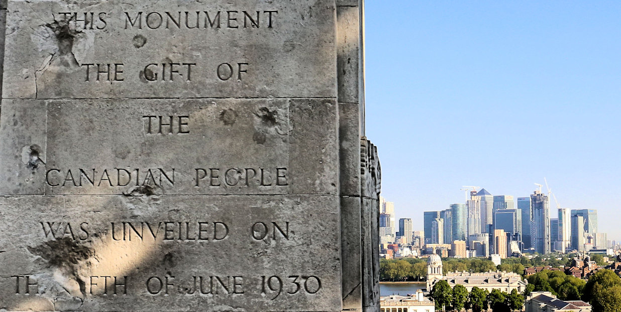
Bomb Damage
On the back of the plinth you will notice a few large indentations.
These were caused by a bomb dropped in the second world war that caused extensive damage to the Observatory.
That was the second bombing of the Observatory, the first being in 1894 when a 16 year old French anarchist named Martial Bourdin blew himself up about 40m from the entrance.
Back to the interactive map
Wolfe's Statue - The Anarchist 61.3
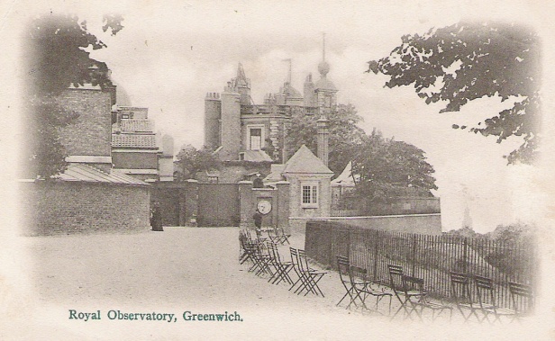
The Anarchist Bomb
The aim of the anarchist attack of 1894 remains a mystery to this day.
It appeared that Martial Bourdin accidentally set off the explosives he was carrying after tripping up about 40m from the entrance.
Miraculously surviving his horrific injuries, he was taken to the Seaman's hospital, but died shortly after, refusing or incapable of explaining his motive.
The fact that he was also found to be carrying an extremely large sum of money further confused things.
The government concluded that he had intended to blow up the observatory because the French were jealous of its success, but the anarchist group he was a member of denied this, pointing out that an anarchist would not try to destroy an institution aiming to make the world a better place.
Such was the interest in the story
and its possible motivation, it inspired several writings including the novel "The Secret Agent" by Joseph Conrad.
Back to the interactive map
Wilderness (Deer Enclosure) 62.1
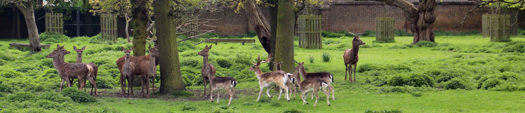
Deer Enclosure
Greenwich Park is the oldest London deer park, having been the home of red deer and fallow deer since they were introduced by Henry VIII in 1510 when he paid a certain Eustace Browne 13 pounds to stock the park.
The red deer are the larger animals with a reddish-brown coat while the fallow deer are smaller with a lighter brown coat with white spots.
If you cannot see any deer from here you can try the other wilderness viewpoint.
Originally the deer were free to roam around the entire park and if you do some roaming yourself you might stumble upon water troughs installed for their benefit.
Increasing visitors and road traffic resulted in them being constrained in what is now referred to as the Wilderness in 1927.
Today the 30 or so deer are carefully managed and you can view them from two areas through fences.
Deer park were important in the Tudor era because hunting was the sport of kings and the aristocracy and having a deer park was the ultimate status symbol of the time.
It was seen as good exercise and recommended by doctors, but was also a demonstration of skills in riding and weapon handling.
It is worth noting that hunting back then was a lot quieter than it would be today as the crossbow was the weapon of choice.
Although guns were available and used in battle they were neither portable nor accurate enough for hunting.
Back to the interactive map
Nelson's Pediment 63.1
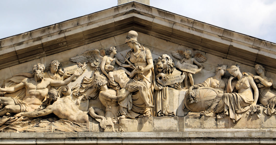
Nelson's Pediment
This central courtyard was much altered after Nelson's death to provide a memorial to him close to where he had laid in state in the Painted Hall.
The Nelson Pediment can be seen above the entrance to the courtyard on the east side and was designed by Benjamin West who was also responsible for the large painting in the Chapel.
It was completed in 1812 and made from Coade Stone, an artificial stone popular at the time.
The pediment shows Britannia at the centre receiving Nelson's body from Victory who is gently supporting it, while underneath them Neptune watches.
On the right a lion behind Britania bears a tablet saying "Nelson's Battles" with Trafalgar and The Nile listed.
The distraught face of a battle weary sailor on the left and three sad women representing England Ireland and Scotland on the right represent the nation's mourning.
It is believed that West was influenced by the carvings from the Temple of Athens which Lord Elgin had recently brought to London.
Back to the interactive map
Nelson's Memorial - Union Jack 63.2
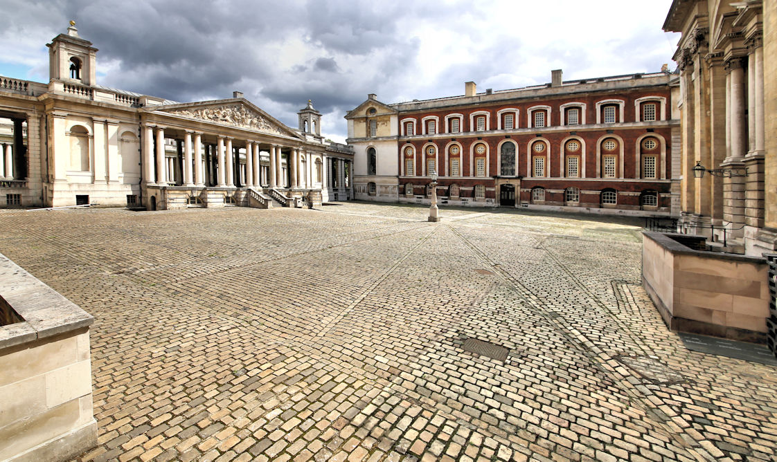
Union Jack
If you look carefully at the unusual cobbling in the courtyard which appears to be undulating in a slightly contrived way, you will see that it has been laid out in the shape of a Union Jack.
You are, therefore, standing on the largest flag in Britain (excuse the paving pun!)
Back to the interactive map
Check out the android app this map is from.
Scroll through this page to see all the content, or you can tap/click on the points to see what's there if you open the interactive map
| Points of Interest | Map Ref |
The various points of interest shown on the map are listed below in sequence. You can search for something using the search button above.
It is so much easier to do this in the app plus you have the benefit of location enabling and audio commentary!
| Greenwich Station | 1.1 |
Greenwich Station
If you have arrived by train then you have travelled along the first suburban railway line in London which was completed in 1836, but not extended to Greenwich until 1838.
At that point Greenwich became the terminus for trains running from Spa Road in Bermondsey (near London Bridge).
The driving force behind the railway was George Landmann who had been born in Woolwich.
After a distinguished career as a military engineer, he became interested in railways and in 1831, with a partner, floated a company called "The London and Greenwich Railway" to design and build this line.
In 1833 it received the parliamentary approval required to start building.
The railway is 3.
4 miles long and carried on a single viaduct consisting of 851 brick arches and 27 bridges which were able to carry the trains over the existing roads.
He employed 400 workmen who in 3 years laid over 60 million bricks, the sheer number of bricks causing a brick shortage in the country.
The rather attractive and smart station building in yellow London stock brick dates from 1840 and is, therefore, one of the oldest remaining train stations in the world (the oldest dating to 1830) and is of particular interest as it was personally designed by George Landmann.
It was another 30 years before the engineers had another idea to avoid roads and built the first underground railway.
Back to the interactive map
| Antique Market | 2.1 |
Antiques Market
Just next to the Picture House cinema you may find a market specialising in antiques depending on the day of your visit.
Venture to the back and you will find two large pieces of stonework from the workshops for the blind set up by Major General Bainbrigge to provide employment to the blind of Kent.
There was a shop which sold the various items of chandlery manufactured, such as ship fendoffs, cork filled life-buoy cushions, baskets, rugs, caned chairs, ship brooms, baskets, rugs and mattresses.
It was James Nasmyth who funded the building in 1892 and you can see his name in the inscription.
He was made his fortune from the invention of the steam hammer, but was also an artist and photographer.
The workshop moved to Peckham in 1972 to make way for the hotel and cinema that take their place today
A Second Railway Station
What you will find little sign of today is that this area once had a railway station which opened in 1888 and was called "Greenwich Park".
It was never very successful because the original line and station from 50 years earlier remained more popular.
It was eventually closed in 1917 having run at a loss for many years.
The old station building was used as a billiard hall until it was eventually demolished in the 1960s.
Today the Ibis hotel stands exactly where the station building once was with the car parks here being the site of the platforms.
Back to the interactive map
| Antique Market - James Nasmyth | 2.2 |
The Moon, Considered as a Planet, a World and a Satellite.
James Nasmyth was fascinated by astronomy and had a large telescope built so he could study the stars.
He also spent a lot of time making detailed drawings of the moon.
Working with James Carpenter, an astronomer at the Royal Observatory, in 1885, he published a detailed book about the moon, mapping its surface and using his artistic skills to provide some astonishing photographic images of the moon's surface.
To create the photographs he made detailed models of his drawings in clay and then took photographs of these with strong directional lighting so that the images looked as life-like and dramatic as possible.
The authors had concluded that the moon was geologically active and the craters on the moon were volcanic in origin as this was how they formed on Earth.
Although we now know the craters were formed by asteroids and other bodies hitting the moon, the book is still to be admired for the detail it provided on our nearest neighbour.
Back to the interactive map
| Dairyman | 3.1 |
Dairyman
Doug Mullins was the last of a family of milkmen who served the local community from 1926 to 1991, with Doug taking over from his father Bill after his death in 1980.
Tragically Doug collapsed outside his shop, which was on this site, and died shortly afterwards in Greenwich Hospital.
As a local celebrity his funeral was very well attended and this plaque showing his red and white milk float was erected to commemorate both his death, and the passing of the era of the clanking bottles and cheery smile of a local milkman.
Back to the interactive map
| The Point (Blackheath) | 4.1 |
The Point
The point offers another impressive view across London this time from the North West edge of Blackheath at the top of Royal Hill.
It is the best view point for sunsets and also affords a very good long distance view of the Central London new years eve fireworks so can be quite busy that night!
Jack Cade's Caverns
Under The Point are some caverns known as Jack Cade's caverns named after the leader of the popular revolt of 1450 by the people of Kent against their mistreatment by the army of King Henry IV.
Although he would have camped on Blackheath twice there is actually no evidence of him hiding in here after the revolt collapsed and he fled to Sussex.
The caverns are actually chalk mines from the 17th Century.
As a very pure form of limestone, chalk was used to make "lime" by lime burners to manufacture mortar.
Rediscovered by accident, they had a spell as a tourist attraction before closing in 1854 because of reports of some notorious parties that were being held there late at night.
The caverns were accessed by a flight of 40 steps and consist of three main chambers linked by passage ways one of which contains a well, which may be part of the reason that the legend of the caverns as a hiding place came into being.
The last time these caverns were viewed was in 1939 when they were briefly reopened to investigate whether they could be used as an air raid shelter, but they were not deemed suitable.
If you want to get a sense of what they would be like, your best bet is to visit Chislehurst caverns which are similar and still open today.
Back to the interactive map
| Conduit Head | 5.1 |
Hyde Vale Conduit Head
Before the advent of modern utilities, buildings or locations that required a significant and regular supply of water had to capture it from rain and springs and store it in a private reservoir.
The water collected was channelled through conduits either cut into the ground or dug out as underground "pipes".
It flowed by gravity to a storage site, in this case, the reservoir under Standard House 50 in the park due south of here.
(See entry in this guide).
Sometimes the water flow was made accessible at a higher point through a conduit head like this one.
Despite some later repair work and restoration, the Hyde Vale conduit head remains true to its original design and materials.
It was constructed about 1710, most likely by Hawksmoor, when the conduit system under Greenwich Park dating back to medieval times was restored and extended to form the water supply to the Royal Naval Hospital.
Back to the interactive map
| Star of the Sea Church | 6.1 |
Our Ladye Star of the Sea Church
The first church here was built for catholic seamen from the Royal Naval Hospital, a reflection of the huge international and diverse population that the royal navy accumulated as the attrition from disease meant that it had to recruit new sailors in every port.
Rebuilt between 1846 and 1851 the church is now a prime example of the Victorian ideals of Catholicism and the 18th century obsession with gothic architecture.
Back to the interactive map
| Reservoir Conduit | 7.1 |
Reservoir Conduit
This building known as "Standard House 50" is the access point to an underground reservoir in the hillside behind it constructed around 1695 to provide fresh water to Greenwich Hospital.
It has a volume of 250 square metres and although it has not served its original purpose for a long time it was used during the second world war as an air raid shelter and even had toilets installed.
This building is the most conspicuous of a number of smaller constructions that allowed access to the maze of underground tunnels that exist throughout the park.
The courses of some probably date back to the original Tudor palace of Placentia, but all were modernised when the hospital was built and it is these that can be seen today.
Although these conduits are closed today, they are in many cases large enough to walk through and lined with red brick.
If on your journey round the park you see something that looks like there might be a tunnel behind it or under it, then there almost certainly is.
If you walk round the west side of the building you will see a vent stack and a drain cover.
These are old access points to the conduit which runs under here and then under the road and up to Hyde Vale.
Back to the interactive map
| Henry Moore statue | 8.1 |
Large Standing Figure: Knife Edge
Henry Moore is a very recognised name and he has a very recognisable style seen clearly here in the Knife Edge.
Less well known is that he also had a passion for exhibiting his works in open space: "Sculpture is an art of the open air.
.
.
I would rather have a piece of my sculpture put in a landscape, almost any landscape, than in, or on, the most beautiful building I know.
"
"Large Standing Figure: Knife Edge" was finished in 1976 and is one of several statues called Knife Edge.
The sculpture is sometimes called Standing Figure (Bone) or Winged Figure.
The sculpture is based on a fragment of a bird's breastbone with the characeristic sharp diagonal detailing, to which a base and a rounded head have been added.
The resulting composition resembles a human torso and evokes comparison to classical greek sculptures.
Moore personally selected this location for his statue when it was installed in 1979, but following concerns over graffiti and a spate of thefts of Bronze statues to be melted down for scrap metal in 2007, it was removed by its owner, the Henry Moore Foundation, for safe keeping.
It was reinstated in time for the 2012 Olympics and it is hoped that the statue will remain where Henry Moore himself chose to place it for many years to come.
Back to the interactive map
| Henry Moore statue - Henry Moore | 8.2 |
Henry Moore
Henry Moore is a key figure in British art and one of the world's best known abstract sculptors with prominent examples of his work in almost every major city.
Henry Moore's career was much influenced by war.
He started out as a teacher, but following the first world war where he survived a gas attack at the battle of Cambrai he moved into art using his ex-serviceman's grant.
During the second world war he became an official war artist and during this time established a strong reputation culminating in a retrospective of his work at the New York Museum of Modern Art in 1946.
Back to the interactive map
| Tumuli | 9.1 |
Tumuli - Ancient Burial Site
In this area you will find several low mounds either side of the paved path.
These are ancient burial mounds that are over 1,300 years old and were built by the Anglo Saxons within an ancient cemetery of over 30 barrows of which these are the remains.
Although they may not look especially impressive today, this is one of the best preserved sites in the country.
It is a scheduled historical monument and several important artifacts have been found in excavations over the course of the last 300 years including swords and jewellery.
Back to the interactive map
| Secret Garden | 10.1 |
Secret Garden
Greenwich locals usually refer to this garden, which was once part of the Observatory, as the "Secret Garden", presumably because it is well hidden despite being in the centre of the park.
Its sheltered and shady location give it a pleasant microclimate and it is the ideal place for a secluded picnic on a hot summers day.
The present entrance was only built in the 1960's and prior to this the garden was part of the observatory and private being accessed directly from the basement of Flamstead House through a tunnel.
Unfortunately the tunnel no longer exists but you can climb up and walk through the paths between the flower beds to get a feeling of how arrival by this unusual method may have felt.
Back to the interactive map
| Meridian Line | 11.1 |
Zero Degrees
The brass strip in the path here indicates the position of the Greenwich Prime Meridian, so standing astride this line you are partly in the Western Hemisphere and partly in the Eastern Hemisphere.
You can also see the meridian line when visiting the observatory in the courtyard.
It extends in a northerly direction just passing by the west side of the O2 and at night is illuminated by a laser beam.
The first Royal Astronomer at Greenwich, John Flamstead, was given the task of improving the accuracy of the star charts used for navigation by accurately recording and documenting them from the observatory.
As the star measurements were made using a telescope on this line, Greenwich was the reference point and so became zero degrees, neither east, nor west.
The observatory museum will show you some of the telescopes that were used in this work and also covers the important development of accurate clocks that did not need a pendulum by John Harrison.
Back to the interactive map
| Meridian Line - Navigation by the stars | 11.2 |
History of Star based Navigation
When the observatory was founded by Charles II in 1675, ships could work out very roughly where they were by locating the position of the sun or stars in the night sky.
To determine how far north or south you were from the equator was done by measuring the angle of Polaris the (Pole Star) to the horizon (or The Southern Cross if you were south of the equator).
Determining how far east or west you were was more challenging because the earth rotates in that direction.
The first thing you had to do was work out the time at your current location using the position of the sun or stars.
Then you needed to know what the time was at a known north to south meridian you had chosen.
Measuring the time using the stars was more accurate than using the sun as you could take multiple height readings for different stars.
To get the time you then had to reference tables of data to translate those angles into a time.
Measuring from the horizon was also made more accuate with the development of the sextant in the mid 18th century.
Apart from the need for a clear sky there were two practical problems with this method.
Firstly the star positions were not very accurately recorded and secondly there was no way to know what the time was at your chosen meridian as pendulum based clocks did not work on a rolling ship.
The work of John Flamstead at the observatory produced the star position tables so that solved the first problem and made Greenwich the default meridian position, but designing an accurate clock that would work on a ship was another matter altogether.
A pendulum based clock was great on dry land where it stayed still and the pendulum swing was a constant frequency, but useless on a ship where even gentle rolling made the pendulum's swing eratic.
The solution to this was developed by John Harrison and replaced the pendulum with a spring loaded oscillating flywheel which moved constantly independent of its orientation, but there were many other engineering innovations required to deliver the required accuracy.
With an accurate clock, a clear sky, and the Greenwich Observatory star data, ships could now tell where they were to within a mile or so, a major breakthrough in safety for all those at sea.
Back to the interactive map
| Meridian Line - Really Zero Degrees? | 11.3 |
Is this Zero Degrees?
Some of you may be puzzled that your GPS coordinates do not show zero longitude when you are standing on the meridian.
Your GPS will place the meridian about 100 meters east of here.
This is because GPS uses a modern global standard called WGS84 designed to best fit longitude and latitude accurately to existing maps.
Based on this requirement, and the shape of the earth, it had to select its own new meridian line.
Hopefully you are not too disapointed now.
Back to the interactive map
| Observatory View Point | 12.1 |
View from the Observatory
There is a lot to see from this vantage point which has been made more interesting by the development of Canary Wharf.
Apart from the obvious features of Greenwich, including the best view of the Queen's House and Maritime Museum, there is an excellent view of eastern London, including the financial district: the City.
From left to right look out for St Paul's Cathedral, the tall thin telecom tower, the City with all its unusually named towers (Shard, Cheese Grater, Gerkhin, Tower 42 and Walkie-Talkie).
Then you have the Cutty Sark, Canary Wharf with its expanse of office blocks and before the Dome you have a great view of the chimneys of Greenwich's own mini Battersea Power station, which is still used to power London Underground.
The hill you are standing was much altered during the great landscaping of Charles II.
Not only was the Observatory built, but the actual slope before you was carved into terraces lined with hawthorn hedges.
By Victorian times the slope had been restored and it was a popular pastime to go running down the hill trying to stay standing, especially during the Greenwich Fair (see "The Pier").
Back to the interactive map
| Western Admiralty Reservoir | 13.1 |
Western Admiralty Reservoir
The reservoir is no longer used and is covered and fenced off so you can only walk around its perimeter and imagine the inside which is extremely impressive.
It was built in 1844 by Sir William Denison to improve the water supply to Greenwich Hospital and the naval dockyard at Deptford where he was the chief engineer.
It is part underground and part above ground.
With a circumference of over 250 metres and a capacity of 5,000,000 litres, it is the largest single structure that fed the maze of historical water conduits under the park.
It is directly connected to the reservoir under Standard House 50 listed in this guide as Reservoir Conduit.
It was only used for 26 years before the hospital was closed and at that point the building was grassed over and screened by trees as it is now.
If you were able to climb down into the building you would find yourself enjoying both the echos and architecture of a huge circular cavern.
It is built in red brick as a set of concentric circular arched roofs supported on columns where they join, providing a large circular space to contain the water.
Back to the interactive map
| Rose Garden | 14.1 |
Rangers House and Rose Garden
Installed in the 1960's its fairly obviously the Rose Garden is only really worth visiting between June and July when everything is in bloom and full fragrance, but if you are in the park during those months, and love the sight and aroma of roses do take a look.
Rangers House was built in 1699 by Captain Francis Hosier in a simple Palladian style and was the first house to be sited near the Royal Observatory which had been completed only four years earlier.
If you want to visit Ranger's House you will need to exit the park unless the small gate on the left side is open.
Back to the interactive map
| Rangers House | 15.1 |
Rangers House
Rangers House was built in 1699 by Captain Francis Hosier in a simple Palladian style and was the first house to be sited near the Royal Observatory which had been completed only four years earlier.
Hosier was a vice admiral in the navy and probably made his fortune from booty gained by capturing enemy ships.
The location of the house would have given him excellent views over the nautical activities in Greenwich and on the Thames.
After he died in 1727 while blockading the Spanish in the West Indies, the ownership of the house was contested and it took until 1740 for it to pass to his mother's family at which point it was immediately leased to the Earl of Chesterfield.
On the earl's death, his son, Lord Chesterfield, took over the lease and had the building extensively remodelled, becoming his favourite "villa".
The role of Ranger of Greenwich Park was first given to Caroline of Brunswick, but after she left the country and her house was demolished, Chesterfield House, as it had become known, was purchased by the crown and in 1815 became the official residence of the Ranger of Greenwich Park with the appointment of Princess Sophia Matilda, the first in a long succession of royal "grace and favour" occupants.
In 1902 the last Ranger left the house and now English Heritage have installed the collection of Julius Wernher who built his wealth from South African diamonds being one of the founders of the still famous "De Beers" company.
Although Wernher never lived in Ranger's House, the others that did live there used it to house their collections and so we could look on Julius Wernher as the last, but posthumous, occupant.
More details can be found on their website: Ranger's House
Back to the interactive map
| Queen Caroline's Bath | 16.1 |
Queen Caroline's Bath
This deep bath is a remnant of Montague House and was only properly excavated in 2001.
It would have been situated in a luxurious bath house within a glass house.
Montague House was a large royal residence and home to Caroline of Brunswick, the wife of King George IV, between 1798 and 1814.
Her marriage to George IV was bitter and divided from the outset and consequently she lived separately from the King at Montague House where she was able to use her status as the Park Ranger to enclose the surrounding 5 acres of the park for her personal use and indulge in her favourite hobby of gardening.
Fed up with her treatment she eventually moved to Italy in 1814 and the King wasted no time in ordering the house demolished.
The walls of the house that adjoined the park boundary were retained and the bricked up spaces where the windows once were can be seen here in the wall behind the bath.
Back to the interactive map
| Queen Caroline's Bath - Caroline of Brunswick | 16.2 |
Caroline of Brunswick
Caroline's arranged marriage to George IV started as it was to continue with George having already illegally married a member of the court called Maria Fitzherbert.
Caroline was no pillar of virtue and disliked George as much as he disliked her.
She also had a reputation for being eccentric and unhygienic.
The loveless marriage did produce one daughter, Charlotte, after which the couple separated since the sole purpose of having the child was to get parliament to pay off his debts.
George vindictively used Princess Charlotte as a means to antagonise Caroline, refusing her permission to see her.
Eventually she had had enough of this treatment and Caroline left Britain for Italy in 1814.
After leaving for Italy she remained a very popular figure in Britain and counted Jane Austin as one of her fans: "Poor woman, I shall support her as long as I can, because she is a Woman and because I hate her Husband.
" George IV was heavily despised and when he tried to formalise the divorce it was clear that because of her popular support the House of Commons would never pass it.
To get her to agree he gave her a pension of 50,000 pounds per year, the equivalent of about 4 million pounds today.
Although she loved gardening, this modest daytime activity was in stark contrast to the raucous evenings when she held extravagant parties or would entertain her various lovers.
Back to the interactive map
| Lake | 17.1 |
The Duck Pond
The duck pond, or "lake" was introduced to the park as a water feature for the flower garden in the late 19th century and was intended to showcase water loving plants.
In the avian world, word obviously got round that there is plenty of free food going here and as a result the pond in Greenwich Park must have the largest collection of ducks per square metre in the whole of London.
Back to the interactive map
| Bandstand | 18.1 |
Bandstand
As the industrial revolution brought more and more people into the cramped cities and their slums, Victorian town planners recognised the importance of open spaces like parks to maintain good health and public order and wanted to encourage the population to use them.
The idea of brass bands playing in purpose built bandstands proved extremely popular and soon became an essential feature of any respectable Victorian park.
The Greenwich Park bandstand is made of iron following a standard format that was used across the whole of Britain.
It was assembled in 1891 having been cast in sections at the famous Coalbrookdale works in Shropshire, where Abraham Darby had first set up his furnace in 1709, the start of the modern iron industry.
Today the bandstand still occasionally hosts brass bands in the summer, as well as more unusual ensembles, most often on a Sunday, but is also used as a focal point for many of the events that take place in the park.
Back to the interactive map
| Site of Roman Temple | 19.1 |
Site of Roman Temple Complex
Unfortunately there is nothing to be seen here today and you will need to use your imagination.
On the mound here stood a Romano-Celtic temple dating back to the start of the Roman occupation of Britain in AD43 and in use for most of the Roman period.
Roman temples were centres for healing, pilgrimage and worship which would have included making offerings to the gods.
At the top of the escarpment the site would have been visible from the river and also to travellers on Watling Street, the main Roman road between Kent and London, which also passed close by.
This site was first excavated in 1902 and three main areas were revealed.
One of these was part of a tessellated pavement (small squares of tile set in mortar) a tiny portion of which used to be displayed here behind railings.
Subsequent excavations, including one televised in 2000 by "Time Team" found that the complex was extensive and uncovered various artifacts that support it being the site of a temple, including part of an inscription to Jupiter.
Back to the interactive map
| Vanbrugh Castle | 20.1 |
Vanbrugh Castle
Vanbrugh Castle is privately owned so you can only admire it from the outside.
It is not a castle in the true sense, it is actually what is often called a folly, a term for an overly extravagant or mainly decorative building.
Built by Sir John Vanbrugh in the likeness of the Bastille Prison in Paris where he had been incarcerated on spying charges for two years, he lived here from 1719 to 1726.
It is now converted into luxury flats which are leased by the Blackheath Preservation Trust.
Sir John Vanbrugh combined two very different careers, as a pre-eminent architect he designed some of Britain's most famous stately homes, notably Blenheim Palace and Castle Howard, and as a dramatist he wrote restoration comedies such as 'The Provoked Wife'.
He even managed to combine these activities by designing and building the Haymarket Theatre in central London.
Back to the interactive map
| One Tree Hill Conduit Head | 21.1 |
One Tree Hill Conduit Head
This conduit head provided access to the water flowing through the conduit tunnels built under the park.
It is a late 17th century conduit head built in a Classical style and most likely designed by Nicholas Hawksmoor who was the Clerk of the Works at Greenwich between 1698 and 1735.
The central arch, which is now bricked in, would have once provided access to the water in the conduit which flowed down from Blackheath via Queen Elizabeth's Oak.
Conduit heads and houses are rare with three of the thirty three significant examples located in Greenwich.
The plaque above the arch has an inscription which is now illegible
Back to the interactive map
| The Queen's Orchard | 22.1 |
The Queen's Orchard
Staffed and maintained by volunteers, the Queen's Orchard was opened to the public on 15th April 2013 having been returned to the royal park by Greenwich council.
To reflect the legacy of the original Tudor orchards it has been planted with fruit trees that date back to the 14th Century and include apple, pear, cherry and others such as quince and medlar.
As well as the actual orchard there are also two ponds, a well and a number of raised flower beds.
The Orchard is usually only open in the summer on Sunday afternoons, but it may be open on other occasions.
The Queens Orchard
Back to the interactive map
| Boating Lake and Sundial | 23.1 |
Boating Lake and Sundial
If you are visiting in the summer and really want to "push the boat out", then hire a pedalo and float around the boating lake for a while taking in the view of the observatory.
Next to the well-equipped children's playground, the boating lake has been a popular feature of the park since 1930, but is only filled with water for the summer months.
In 2012 it featured in the Olympics as a water jump for the equestrian cross country event.
The horses came down the hill entering on the south side, turned, jumped and exited on the east.
Details on hiring a boat can be found on their website.
Park Boats
Sundial
On the north side is a sundial which was designed by the celebrated sundial designer Chris Daniel and installed in 1999 to mark the new millennium.
Unfortunately it was meant to be on the meridian line, but is slightly off due to some construction mistakes, and, even worse, it is supposedly not quite oriented correctly so at noon is around 15 minutes fast! However, check the next tab, as this could simply be that some people are not clear how it works.
Back to the interactive map
| Using the Sun Dial | 23.2 |
How the Sundial works
If it is a nice sunny day you can check out how the sun dial works.
This is a Double Horizontal Dial and is designed to show both the time and the direction of the sun.
The part that casts the shadow is made from bronze in the shape of a right angled triangle and known as the gnomon.
On the ground is the dial plate which looks like a compass rose.
The time is indicated by the shadow from the sloping edge of the gnomon and the direction of the sun is shown by the shadow from the vertical edge.
Unfortunately the shadow does not quite reach the dial.
Sun dials are obviously not the most accurate way of telling the time, but should generally be accurate to around plus or minus 5 minutes.
This one is particularly simple and so is less accurate than ones which take into account the seasons.
Do remember that the time it shows is Greenwich Mean Time and so will be one hour behind the actual time in the summer.
Back to the interactive map
| Nelson and the Trafalgar Tavern | 24.1 |
The Trafalgar Tavern
The Trafalgar Tavern opened in 1837 and was frequented by Charles Dickens as well as being home to the celebrated annual whitebait dinners of parliamentary cabinet ministers.
These took place in the function room upstairs and the last of these dinners had William Gladstone in attendance.
Just before the tavern there is a statue of Nelson and a great view down the river towards the O2 and the cable car.
Running down the side of the Trafalgar Tavern is Crane Street, typical of how all the streets in Greenwich would have appeared in the nineteenth century.
For more information on the Trafalgar Tavern visit their website.
The Trafalgar Tavern
Charles Dickens on Politicians
Politicians have always been publicly derided, and Charles Dickens had something to say on the matter:
"Why do Cabinet Ministers eat whitebait? And why do they eat them at the close of the parliamentary session in a tavern at Blackwall or Greenwich? Whitebait, being fish, are cold-blooded animals; but is there on this ground any analogy between them and Cabinet Ministers?"
Back to the interactive map
| Nelson and the Trafalgar Tavern - Crane Street | 24.2 |
Crane Street
Just after the tavern, on the left, is a pedestrian alley way called Crane Street which is interesting in that it is what many of the streets around Greenwich would have looked like back in the 19th Century, narrow with a drainage channel running down the centre of the pathway.
It takes its name from the fact that at that time it had a crane for unloading ships cargo at the far end.
Unlike now, most of the buildings would have been weather boarded in horizontal overlapping strips of wood generally painted white giving a characteristic maritime feel to the area
Back to the interactive map
| Naval College Water Gate | 25.1 |
Water Gate
Water Gate is the entrance to the Old Royal Naval College or Hospital from the river Thames and is opposite steps allowing access to and from a boat.
In the centre of the gate, in two sections, you will find an example of the original coat of arms of the Royal Hospital with its four anchors bound in rope.
This is also an excellent point to take in the view towards the park and observatory and admire the buildings and symmetrical layout.
Facing the park you can see the two domed towers of the naval college.
There is a clock on the left tower and a dial on the right tower that looks like a clock, but shows the wind direction.
On your right is the oldest part of the Naval College which was constructed by Charles II after he demolished the original Palace of Placentia in 1664.
It was meant to be a new palace to rival the best in europe, but he abandoned the project before completion so this part stood alone and was never occupied.
It was eventually incorporated into the naval hospital by the architect Christopher Wren when building started around 1696 on the instructions of Queen Mary and William VI.
Consequently this building still has some ostentatious carvings around the entrances including the inscription "Carolus Rex II" unlike the building on the left which was added by Wren as a mirror image.
Also from here, the white Queen's House can be seen between the twin domes of the Naval College.
It had already been built by James I 30 years earlier in 1635.
Queen Mary insisted that its view towards the river be maintained and rejected the initial plans from Wren, because they included a single large central domed hall obscuring the view.
The final plans retained the two symmetrical buildings and added the two domes you see now.
Finally, this gate was used by the Naval College to serve passing honours to naval ships as they went by on the Thames.
This ancient tradition usually reserved for passing ships, involved senior officers piping from the deck of the ship and also from the steps of this gate.
Back to the interactive map
| Naval College Water Gate - Greenwich Beach | 25.2 |
Greenwich Beach
Turning back to the river, if the tide is very low, then the steps here will lead down to what is known as "Greenwich Beach" which even has a small patch of sand near to the pier.
You will also be able to see the remains of oak piles sticking up out of the river bed which were part of a Tudor landing stage for the Palace of Placentia.
Conversely, if the tide is very high you will need to be careful as the path here often floods, especially if a fast ship goes by.
On the opposite side of the river you can see Island Gardens on a peninsula called the Isle of Dogs reputedly because Henry VIII kept his hunting dogs here.
Back to the interactive map
| Bellot Obelisk | 26.1 |
Bellot Memorial
Standing by the river path, this red granite obelisk is a memorial to a French man, Joseph Rene Bellot, who died in the Arctic aged 27.
It is a statement of his enormous popularity in Britain in the 1850's which was gained from his enthusiastic involvement in missions to locate the lost Franklin expedition, a major international news story at the time.
The monument was funded entirely by the public after Bellot's death in 1852.
It was designed by the architect Philip Hardwick who was the surveyor of Greenwich Hospital and unveiled in 1855.
Back to the interactive map
| Bellot Obelisk - Joseph Bellot | 26.2 |
Joseph Bellot
Joseph Bellot was a Frenchman who first embarked from Greenwich in 1851 as a volunteer on H.
M.
S.
Phoenix under the command of Captain William Kennedy in search of Sir John Franklin.
In 1852 after promotion to the rank of lieutenant he accompanied Captain Edward Inglefield on another mission to find Franklin.
His personality, daring exploits and courage won him wide admiration at the time and he became a bit of a celebrity figure.
On August 18 1853, while making a perilous journey across an ice floe with two comrades, he suddenly disappeared through a crack and was never seen again.
He was just 27 years old.
As well as this Obelisk, he also has a small impact crater on the moon named after him on the southwest edge of Mare Fecunditatis.
Back to the interactive map
| Bellot Obelisk - Franklin Expedition | 26.3 |
Franklin Expedition
The fate of the Franklin Expedition retains much mystery even today.
In 1845 the experienced Arctic explorer Sir John Franklin set sail with 128 men in two reinforced and well equipped ships on a three year voyage to locate and chart the north west passage.
This long dreamed of route through the arctic would significantly shorten the journey to the Pacific from Europe if it could be found.
Nothing was heard from Franklin's expedition for two years and in early 1848 pressure from his wife and Parliament forced the government to commission a search party and sponsor rewards for anyone able to locate him and his men.
Such was the fascination with the arctic at the time, that many other countries and even individuals sponsored searches.
Tragically, the efforts were futile and although some artefacts and bodies were found with help from the native Inuit population, it was not until 2014, 150 years later, that the wreck of one of his ships, HMS Erebus, was finally discovered by a systematic sonar search undertaken by Park Canada.
HMS Terror, the other ship, was discovered 2 years later.
The full story remains unknown, but there is enough evidence to show that the usual summer thaw which would have freed the boats from the ice did not take place for two seasons and their supplies began to run out.
Trapped in this icy desert, the deprivation that these poor men suffered can barely be imagined and is witnessed in their desperate attempts to escape and stay alive.
Back to the interactive map
| Greenwich Pier | 27.1 |
Greenwich Pier and Introduction
The pier is a great place to get oriented for your visit to Greenwich and if you have come by boat, that was a good choice because it gives an idea of how the river Thames has been so important in shaping Greenwich into the globally recognised cultural centre it is today.
If you have come by train, DLR, bus or car, then make your way here and stand with your back to the river.
To your right is the Cutty Sark.
Behind the buildings in front of you are the Park and Observatory.
To your left is the Old Royal Naval College.
These three areas contain the main sights of Greenwich.
If you came by boat you will have seen all these in the spectacular view of Greenwich and the park as you approach the pier, a view that has hardly changed in over 300 years.
Back to the interactive map
| Greenwich Pier - A Brief History of Greenwich | 27.2 |
Brief History of Greenwich
Greenwich has a long history and was first recorded by the Saxons in 918 as the settlement of Gronewic or "Green Bay" it was close to the river without being too marshy and had the high ground of Blackheath nearby.
Later the vikings used Greenwich as a base to attack London and in the Tudor era it became a favoured location for Kings and Queens, in particular Henry VIII and Elizabeth I.
With the growing importance of sea trade and the navy, it developed into a centre for maritime activity and innovation and became the home to an observatory and the prime meridian of the world.
Later came a hospital for infirm sailors, a naval college, a market and a maritime museum.
All the buildings are beautifully designed, but it is the symmetry and way that they fit into the landscape that makes Greenwich such a special place.
In recognition of this rich history and beauty, Greenwich became a UNESCO World Heritage Site in 1997.
In 2012, the Queen made Greenwich a Royal Borough reflecting its many important connections to the Royal Family.
Today Greenwich is home to a university, several museums and hosts numerous events every year reflecting its transition to a must-see tourist destination.
Back to the interactive map
| Greenwich Pier - The Pier | 27.3 |
The Pier
Greenwich had always been a popular place to visit and Greenwich Pier was built in 1836 to accommodate the rapid growth of day trippers who were arriving by paddle steamers operating from central London and Kent.
It also served a ferry across the river to the Isle of Dogs before the foot tunnel was built.
Back to the interactive map
| Greenwich Pier - Greenwich Fair | 27.4 |
Greenwich Fair
These days visitors are drawn to the beauty and history of Greenwich, but for Victorians, Greenwich was not only a popular day out, its character was very much defined by the famous and outrageous Greenwich Fair.
This took place at Easter over three days and was eventually banned by act of parliament in 1857 following a petition complaining about its bad influence on the population of Greenwich and London as a whole.
Today the Greenwich and Docklands International Festival in June has reused the term Greenwich Fair for part of its list of activities, but it is nowhere on the scale or bawdiness of the original fair and instead attracts unusual street acts from around the world.
An idea of the atmosphere at Greenwich Fair can be gained from the author Charles Dickens who wrote about it in "Sketches by Boz".
Some extracts below give a flavour of how important it was in London life at the time, and just how outrageous it was.
"If the Parks be the lungs of London we wonder what Greenwich Fair is.
A periodical breaking out, we suppose, a sort of spring-rash: a three days fever, which cools the blood for six months afterwards, and at the expiration of which London is restored to its old habits of plodding industry, as suddenly and completely as if nothing had ever happened to disturb them.
"
"The chief place of resort in the daytime, after the public-houses, is the park, in which the principal amusement is to drag young ladies up the steep hill which leads to the Observatory, and then drag them down again, at the very top of their speed, greatly to the derangement of their curls and bonnet-caps, and much to the edification of lookers-on from below"
"Imagine yourself in an extremely dense crowd, which swings you to and fro, and in and out, and every way but the right one; add to this the screams of women, the shouts of boys, the clanging of gongs, the firing of pistols, the ringing of bells, the bellowings of speaking-trumpets, the squeaking of penny dittos, the noise of a dozen bands, with three drums in each, all playing different tunes at the same time, the hallooing of showmen, and an occasional roar from the wild-beast shows; and you are in the very centre and heart of the fair.
"
"The grandest and most numerously-frequented booth in the whole fair, however, is The Crown and Anchor a temporary ball-room we forget how many hundred feet long, the price of admission to which is one shilling.
There is no master of the ceremonies in this artificial Eden all is primitive, unreserved, and unstudied.
The dancing, itself, beggars description every figure lasts about an hour, and the ladies bounce up and down the middle, with a degree of spirit which is quite indescribable.
"
Back to the interactive map
| Foot Tunnel | 28.1 |
Foot Tunnel
Close to the river, this small circular building with its unusual glazed dome roof which is lit up at night is the entrance to the Greenwich foot tunnel.
The tunnel is a busy route for tourists and commuters, especially cyclists, with over 4000 people using it every day and it is probably best to avoid the "rush hour" in the morning and evening to have an enjoyable and quiet visit.
Unfortunately the lifts are not very reliable so you might have to take the stairs of which there are 100 on the South side, but only 87 on the North side.
Once in the tunnel the most striking feature is the 200,000 white glazed tiles that cover the walls making it seem especially bright.
You will notice that the tunnel narrows at the north end because of some steel reinforcement over the tiles which had to be added after a second world war bomb exploded in the Thames and caused the tunnel to leak.
It is worth making the effort to decend the 15 meters under the Thames and then walk the 370 meters of the tunnel as the view back to Greenwich from the Isle of Dogs is particularly lovely.
You can also say that you walked under the Thames.
Back to the interactive map
| Foot Tunnel - History | 28.2 |
History
For many years the only way to get to the Isle of Dogs on the north side of the Thames was to take the steamboat ferry from the pier, or a wherry, a traditional small ferry boat.
These were operated all along the river by the Thames Watermen who made their living carrying people and goods across the river for a small fee from numerous steps situated along the banks like the ones just behind the tunnel entrance or those at the front of the naval college (Water Gate).
The Isle of Dogs contained the main port of London which was critical for the import and export trade and a key part of Britain's status as the world's leading economic power, but it was often short of men to fill the roles of stevedores who were essential to load and unload ships.
Potential labour from Greenwich was put off working there because the ferry service was expensive and did not run in bad weather because of the danger of collision with other boats on what was an extremely busy stretch of river.
Greenwich Foot Tunnel was designed by Alexander Binnie who had just completed building the Blackwall Tunnel further down the river.
It took 3 years to build and employed the same tunnelling shield techniques used by Brunel to build the very first tunnel under a river back in 1845.
The caissons were excavated first on either side of the river.
These shafts, which now form the entrance, were lined with cast iron and once they reached the required depth of 15m the tunneling could begin.
The men worked 8 hour shifts 24 hours a day in compressed air and, because they were tunnelling through soft clay, were able to progress at about 3 metres each day.
As they completed each section, cast iron linings were bolted into place so that the tunnel became a long sealled pipe sitting under the river bed through which people could walk.
The inside of the tunnel was then tiled and paved to complete what we see today.
It was opened on August 4th in 1902 to provide a free and reliable river crossing for the large number of Greenwich residents that worked in the great docks.
The original lifts were lined in mahogany and became operational in 1904, remaining in use with a lift operator until 1992 when they were replaced with self-service lifts, with further work on them in 2012.
Although you would not notice, being a pipe in soft clay, the tunnel flexes slightly as the tide goes in and out.
Since it has been in place over 100 years, not something to worry about though!
Back to the interactive map
| Cutty Sark and Gardens | 29.1 |
Cutty Sark and gardens
Cutty Sark Gardens is a popular open space right in the centre of Greenwich.
From this position facing the Cutty Sark you can see the entrance to the tunnel under the Thames to your left by the river, and the Gypsy Moth pub to your right.
In the summer and at Christmas there are often market stalls and other types of entertainment located here.
The Cutty Sark
Right in the centre, dominating the space, is the Cutty Sark, the most famous of the great Tea Clippers.
The ship has been fully restored and is held in a purpose built dry dock.
To preserve the ship's iron and oak hull it is no longer resting on its keel as it did originally when moved here, but instead it is suspended in the air, allowing the unique opportunity to walk right underneath her which you can see through the Windows.
If you walk around her, at the front you can see the figure head "Nanny Dee" wearing a "cutty sark" as well as taking in the masts and hull before returning to the entrance if you wish to go on board.
For more information about visiting the Cutty Sark here.
Back to the interactive map
| Cutty Sark and Gardens - The History of the Cutty Sark | 29.2 |
<History
The Cutty Sark was built in Scotland in 1869 in the twilight years of sail, when wind power was still faster than steam as long as the conditions were right and the boat was well designed.
Tea Clippers had to be fast as their job was to be the first to bring tea from the new harvest in India and China back to England where, as a luxury item, it would fetch the highest prices.
The ship was revolutionary in terms of its construction and had a unique hull shape that gave it the speed it needed.
Despite being a sailing ship the Cutty Sark was very much "Cutting Edge" technology at the time and the ship yard was bankrupted by the cost of building her.
Launched in 1870, the opening of the Suez Canal a year earlier had already given steam ships a 3000 mile short cut that sailing ships could not exploit.
By 1877 the Cutty Sark had completed her last voyage as a Tea Clipper.
In 1883 she was assigned to shipping wool from Australia to England, a task in which she also excelled, setting new speed records for the journey, but by 1895, even this was no longer viable and she became a regular cargo vessel renamed the Ferreira by her Portuguese owners.
In 1922 she was the last tea clipper left afloat and was returned to England and spent time as a tourist attraction and a naval training ship before finally arriving in Greenwich in 1954 having been saved from scrap by the public with the support of the Duke of Edinburgh.
By 2007 it became apparent that the ship's iron frame was being corroded by the high acidity of the oak and the Cutty Sark was effectively dismantled and rebuilt, during which a devastating fire caused by a faulty extractor fan almost finished her off, but on 25th April 2012 the Queen and Duke of Edinburgh reopened her to the public.
Not everyone likes the new design and it has the dubious honour of having won the title worst new building in Britain when it was completed.
Back to the interactive map
| Cutty Sark and Gardens - Nanny Dee | 29.3 |
Nanny Dee
Nanny Dee is the white "figure head" on the bow of the ship.
Cutty Sark's name comes from a poem by the Scottish poet Robert Burns called Tam O'Shanter in which the hero is chased by witches, the fastest of which, Nanny Dee, is wearing a short night dress called a cutty sark:
"Her cutty-sark, o' Paisley harn,
That while a lassie she had worn,
In longitude tho' sorely scanty,
It was her best, and she was vauntie,
Ah! little ken'd thy reverend grannie,
That sark she coft for he wee Nannie,
Wi' twa pund Scots, ('twas a' her riches),
Wad ever grac'd a dance of witches!"
Back to the interactive map
| St Alfege's Church Outside | 30.1 |
St Alfege's Church
Greenwich may not have a cathedral, but it does have a very beautiful and historic church.
It was completed in 1714 by Nicholas Hawksmoor, the protege of Sir Christopher Wren.
The current baroque building is the third church and replaced the medieval church built in 1290 in which Henry VIII was baptised in 1491.
This church unfortunately collapsed, an event which was not that uncommon at the time because of undermining of the foundations by over zealous grave diggers.
The original entrance is via the steps up to the large doors on the North side, just off Greenwich Church Street, but today you have to go past these doors and round the back to the church yard to find the entrance.
Back to the interactive map
| St Alfege's Church Outside - Saint Alfege | 30.2 |
The Story of Saint Alfege
Over one thousand years ago in 1011, Alfege, the Archbishop of Canterbury, was betrayed by one of his own monks and captured by Vikings who had ransacked Canterbury and burned the cathedral to the ground.
He was brought back to the Greenwich marshes which had been established as the Viking's base for raiding London and Kent by their leader Thorkell the Tall.
Alfege was held to ransom, but steadfastly refused to negotiate with the Vikings as he did not want his people to pay for his release out of their own pockets.
After six months, at a feast on Easter Day, 19th April 1012 (now St Alfege's Day) the Vikings, demanding their gold, were incensed by his reply: "the gold I give you is the Word of God" and they clubbed him to death.
News of his death spread rapidly through Christendom together with reports of a miracle where an oar dipped in his blood had sprouted.
A church has stood on the site of his death ever since and he was canonised in 1078.
Back to the interactive map
| St Alfege's Church Inside | 31.1 |
St Alfege's Church Inside
On entering the church take a chance to look around before walking towards the Altar.
On the right in the south west corner behind the baptism font, you will find an old organ console discovered when the main organ was refurbished in 1910.
It is believed that the octaves in the middle keyboard are taken from the tudor organ from the previous medieval church.
On the left of the aisle at the back is a brass plate in the floor indicating that General Wolfe's sealed vault is in the crypt below.
This plate is a copy of the one that is on his coffin.
General James Wolfe lived in Greenwich and was responsible for leading the English victory over the French in Canada resulting in the formation of the current Canadian State (see Wolfe's Statue).
Back to the interactive map
| St Alfege's Church Inside - The Altar | 31.2 |
The Altar
In the Chancel by the Altar you will see in the floor the words "He who dies for Justice dies for God" engraved on a slab, symbolically marking the place where St Alfege was martyred.
Either side, the columns and cornices are true to the original Hawksmoor design and include much of the original fine oak carving by Grinling Gibbons, a master carver famous for his fine work especially in St Paul's Cathedral and Windsor Castle (Note: the wood of the original carvings appears darker and are best seen in the trancepts).
If you look at the side of the stairs of the pulpit you will see one elaborately carved stair end with all the others plain.
This is an original Gibbons carving that was salvaged after the original pulpit was destroyed by a bomb.
Looking back to the Chancel, you will also see paintings by Sir James Thornhill which were uncovered by the restoration work (see Painted Hall).
The wrought ironwork railings of the upper floor are the original Hawksmoor decoration.
Back to the interactive map
| St Alfege's Church Inside - The Crypt | 31.3 |
The Crypt
Apart from Henry VIII, the church has had associations with several famous figures in British history that resided in Greenwich and chose to be buried here.
At the back of the church, as already observed, you will find a brass plate in the floor indicating that General Wolfe's sealed vault is in the crypt below.
Thomas Tallis, the celebrated composer of Choral music in the sixteenth century is known to have been interred here, but the whereabouts of his remains are unknown.
Little is known about his early years, but he progressed from being an organist to composing music, taking up posts at Cantebury Cathedral and the Royal Court where he wrote music for Henry VIII and Elizabeth I and had a house in Greenwich.
Sir John Julius Angerstein, credited with the creation of the pre-eminent insurance underwriter "Lloyds of London" and whose extensive art collection formed the basis for the establishment of the National Gallery is also buried in the Crypt.
He lived in Woodlands in East Greenwich, now known as Mycenae House.
Samuel Enderby, made his fortune from a whaling company he founded in 1773 which resulted in a shipping dynasty that lasted 150 years and was significant enough to get a mention in the novel Moby Dick.
In its final years the company ran a successful rope works at its large Enderby Wharf site which later manufactured the first transatlantic telegraph cable as the buildings were ideal for this purpose.
The church maintains strong ties with Canada because of General Wolfe, but also because of the lesser known Henry Kelsey, a 17th Century English fur trader, explorer, and sailor who played an important role in establishing the Hudson's Bay Company.
Kelsey was born in Greenwich 1667 and is the first recorded European to explore the Great Plains.
Back to the interactive map
| St Alfege's Church Inside - Ceiling | 31.4 |
The Ceiling
The inside of the church is beautifully proportioned and the impressive oval shaped suspended ceiling was the largest unsupported ceiling in Europe when it was built.
Incendiary bombs dropped on the Church in 1941 set the roof ablaze and it collapsed into the nave destroying most of the interior, but leaving the walls and tower intact.
The church was carefully restored after the war and reopened in 1953 having stayed open through the intervening years through use of a temporary church within a church.
The plaster work was faithfully reproduced using traditional techniques, but the roof was reconstructed using modern lighter materials.
Back to the interactive map
| Wilderness View (West) | 32.1 |
Deer Enclosure
Greenwich Park is the oldest London deer park, having been the home of red deer and fallow deer since they were introduced by Henry VIII in 1510 when he paid a certain Eustace Browne 13 pounds to stock the park.
The red deer are the larger animals with a reddish-brown coat while the fallow deer are smaller with a lighter brown coat with white spots.
If you cannot see any deer from here you can try the other wilderness viewpoint.
Originally the deer were free to roam around the entire park and if you do some roaming yourself you might stumble upon water troughs installed for their benefit.
Increasing visitors and road traffic resulted in them being constrained in what is now referred to as the Wilderness in 1927.
Today the 30 or so deer are carefully managed and you can view them from two areas through fences.
Deer park were important in the Tudor era because hunting was the sport of kings and the aristocracy and having a deer park was the ultimate status symbol of the time.
It was seen as good exercise and recommended by doctors, but was also a demonstration of skills in riding and weapon handling.
It is worth noting that hunting back then was a lot quieter than it would be today as the crossbow was the weapon of choice.
Although guns were available and used in battle they were neither portable nor accurate enough for hunting.
Back to the interactive map
| View from One Tree Hill | 33.1 |
One Tree Hill
Somewhat off the normal tourist trail, One Tree Hill is a lot less busy than the Observatory and does give you a very different perspective of the park.
To the east you can see Vanbrugh Castle and to the west there is probably the best view of the Royal Observatory you can get.
Looking north across the river with the boating lake in the foreground, you have a clearer view of central London, including the London Eye.
Back to the interactive map
| National Maritime Museum Main Entrance | 34.1 |
National Maritime Museum
The National Maritime Museum is the largest museum of its kind in the world and has exhibits about all aspects of the history of seafaring.
Since the sea has played such a pivitol role in British History, it covers many important historical events so you don't need to be a fan of ships and the sea to appreciate its impressive collections.
It is housed in buildings that belonged to the Royal Hospital School founded in 1712 as part of the Hospital.
When the school moved to new buildings the Museum was created over the course of 10 years, opening in 1937.
Since then the building has been extensively modernised to provide additional space and house multiple galleries suitable for all ages.
The museum has two entrances, this is the main one, a second entrance opens into the park and has a cafe next to it.
For more information on the Maritime Museum visit their website: Maritime Museum
Back to the interactive map
| Queen Elizabeth Tree | 35.1 |
Queen Elizabeth's Oak
An acorn took root sometime in the twelfth century well before 1433 when the park was first enclosed and over 500 years before it was landscaped in 1660.
By then, the ancient oak tree was impressive enough to be spared the axe during the extensive replanting and was instead incorporated as a significant feature.
Although it died around 1880, it was so substantial that it remained standing until 1991 when it was finally toppled by hurricane force winds.
A new oak has been planted in front of the remains of the original.
The name of the tree derives from the story that during her walks in the park the young Queen Elizabeth took refreshments inside the tree, which was hollow and afforded some protection from the elements.
According to some it was later turned into a lock-up for transgressors of park rules through the fitting of a door.
There is also a story that Elizabeth's parents, Henry VIII and Anne Boleyn, danced around this very tree during their courtship.
The Oak is the national tree of England, and this long dead tree is testament to the economic and military importance of the oak forests that once covered the south of England.
These forests played their part in making the area around Greenwich a key location for the construction of ships and hence supported the development of the first major naval power in the world.
Back to the interactive map
| Queen Elizabeth Tree - Conduit Cover | 35.2 |
Queen's Oak Conduit Cover
South of the remains of the tree you will see some slabs and an iron seal indicating the presence of one of the two known water conduits under the park.
This one is referred to as the One Tree Hill conduit because it terminates at the foot of that hill in a Conduit Head designed by Nicholas Hawksmoor.
Back to the interactive map
| Queen's House Haha Gate | 36.1 |
Queen's House Haha
A haha is a ditch and wall frequently used in mansions that face onto land containing animals.
Rather than build a wall to keep the animals off the lawns that would then obscure the view, the wall is sunk into a ditch so that when the landscape is admired from the mansion, in this case the Loggia of the Queen's House, it appears as if there is no wall and the land just extends into park.
Back to the interactive map
| Greenwich Market Food Court | 37.1 |
Greenwich Market - Food
In the early 1800's Greenwich Market was mainly selling food and other household essentials.
This included both live animals and butchered meat and the much altered stables and slaughterhouse buildings are still standing near the new food area.
There was almost no regulation on the hundreds of private slaughterhouses in London at the time and the conditions would have been cruel, insanitary, and noisy.
It is very hard to imagine how different this area would have looked, sounded and felt at that time.
Continual lobbying from butchers meant that the government took no effective action to resolve the situation until 1890 when they finally obtained the power to close unhealthy slaughterhouses and could force butchers to use the new centralised abattoirs, the nearest of which was in Deptford.
Back to the interactive map
| Greenwich Market North | 38.1 |
Greenwich Market - Admiral Hardy
During the nineteenth century the market was improved and when the Admiral Hardy pub built a small theatre by extending over the north entrance arch in 1845 the inscription "A false balance is an abomination to the Lord, but a just weight is his delight.
" was added.
By 1908 the timber roof had become dangerous and it was replaced by the steel roof that covers you today although this was extensively repaired in 2015.
If you don't like crowds, or want to see the buildings rather than shop then you should visit midweek when it is much quieter.
You can find more details on their website: Greenwich Market
Back to the interactive map
| Naval College West Entrance | 39.1 |
Old Royal Naval College, West Gate
The west gate is the most imposing entrance to the Naval College with its two pillars topped by globes.
These commemorate the circumnavigation of the world by George Anson in 1744 as part of a naval mission to attack the Spanish in South America.
His vast personal fortune was obtained from the 'spoils of war' when he collected 1,313,843 pieces of eight from the capture of a Spanish galleon.
It is worth noting that two thirds of his crew died during this voyage, mainly from scurvy.
Such a death rate may seem incredible today, but this was not uncommon in the navy at that time, where the importance of fresh food in the diet was not understood.
It was this high death rate that meant that the navy tended to be populated with poor foreigners picked up in the last harbour, or even drunks "press ganged" into service against their will.
Back to the interactive map
| Flower Garden | 40.1 |
The Flower Garden
The Royal Parks keep this garden in top shape with seasonal plantings so that outside of the winter months you are always greeted with a huge splash of colour.
It is also a nice place for young children to play as no dogs are allowed and the trees make good hiding places.
You can also go and see the deer.
History
Originally this whole area was was part of the wilderness inhabited by the deer, but in 1854 work began to create an ornamental garden, including the construction of nurseries to provide the plant stock which are still working and located in the south east corner.
What plants there were had to be protected from the deer by their own individual fences until the deer were fenced off from the rest of the park as they are today.
The planting continued until 1900 at which point the gardens were relatively unique for a public park.
"The Gardener's Chronicle" said in 1925: "one would imagine oneself to be in the midst of a beautiful garden attached to some stately home", and that is undoubtedly still true today.
Back to the interactive map
| Naval College Painted Hall | 41.1 |
The Painted Hall
The Painted Hall houses one of the great painted ceilings of the world.
The hall was designed by Sir Christopher Wren and his assistant Nicholas Hawksmoor and when completed was painted by Sir James Thornhill over a further 19 years between 1707 and 1726.
For more information visit the ORNC website
Back to the interactive map
| Naval College Painted Hall - Painted Hall | 41.2 |
Inside the Painted Hall
Originally designed as the dining hall for the hospital residents, in 1824 it was decided that the hall was far too grand for that and this function was moved downstairs to the under croft.
The hall became a naval art gallery and served this purpose until 1937 when the Maritime Museum was opened and could house the collection.
When the hospital was converted into the Naval College in 1869 the hall was returned to its original purpose and used for both officers dining and banquets.
Its most sombre moment was in January 1806, being the place where Lord Nelson's body was held in state as part of one of the most impressive funerals in British history which included a full naval escort for his body up the Thames.
There is a plaque in the floor marking where the coffin stood.
Back to the interactive map
| Naval College Painted Hall - The Main Painting | 41.3 |
The Main Painting
Although somewhat overshadowed by the magnificent ceiling, the painting at the far end of the hall is no less impressive showing the Hannoverian King George I resting his elbow on a globe depicting his control over the world while receiving his sceptre from the mythical character "Peace".
The scales of justice are held just above his head.
Although born in Germany, George became King, because Queen Anne had died without an heir and he was next in line by birth.
The Latin inscription at the top of the painting "IAM NOVA PROGENESIS CAELO" means "now a new lineage is sent down from heaven".
He is surrounded by his family in a classical setting with his son, destined to be George II, standing to his left and his elderly mother, the Electress Sofia of Hannover, seated behind them.
His wife, Sophia Dorothea of Celle, is not shown as they were estranged, but directly behind him is his daughter in law the Princess of Wales next to her daughter who is holding a mirror.
His grandchildren are at his feet on the stairs.
In the background is the dome of Saint Paul's cathedral, acknowledging Sir Christopher Wrens best known architectural achievement.
Finally, at the bottom on the right, is a self portrait of James Thornhill beckoning you to admire his work.
There is a popular story that during the painting Thornhill never felt that his efforts were adequately appreciated, especially financially, and he is holding out his left hand apparently reminding parliament that he still needed to be paid appropriately for his work.
More likely he is adopting a typically pretentious pose of that era and perhaps thanking George I for his knighthood.
Back to the interactive map
| Naval College Painted Hall - The Ceiling | 41.4 |
The Ceiling
The painting depicts peace and liberty defeating tyranny and tells many stories related to the monarchy and naval power, covering battles, conquests and even the work of the observatory through various historical or mythical scenes.
King William III can be seen centre stage with Queen Mary.
Behind them are the virtues.
On their right with her lambs, Peace hands William an olive branch while he in turn hands the red cap of liberty to Europa who is kneeling on his left.
Under William's feet, crouching with a broken sword is the defeated Louis XIV of France.
Apollo rides his chariot above them and below Architecture holds up Wren's design for the hospital, while on the right the naked figure of truth supported by time holds up the sun.
Around the inside of the oval frame, there are references to each of the four seasons while on the outside are the signs of the zodiac.
Around the main painting there are many references to the navy and naval technologies of the time.
In back left corner, the observatory is referenced by a picture of Flamsteed with his assistant by a telescope.
In front of him is a date refering to a famous total eclipse of 1715 over London which was accurately predicted by Edmond Halley to within a few minutes using Flamsteed's sun and moon data which was a major scientific breakthrough at the time and of which Halley said:
The like Eclipse having not for many ages been seen in the southern parts of Great Britain, I thought it not improper to give the public an account thereof, that the sudden darkness, wherein the stars will be visible about the sun, may give no surprise to the people, who would, if unadvertised, be apt to look upon it as ominous.
Hereby they will see that it is no more than the necessary result of the motions of the sun and moon, and, how well those are understood.
Back to the interactive map
| Naval College Painted Hall - Skittle Alley | 41.5 |
The Skittle Alley
If it is open, it is worth visiting the old skittle alley underneath the hall which was constructed as an amusement for the hospital patients and is an interesting contrast to modern ten pin bowling alleys.
Occasionally you even get a chance to have a go.
Back to the interactive map
| Island Gardens | 42.1 |
Island Gardens
If it was an inspiration for Canaletto, the great Venetian painter, then hopefully you will find the walk under the river is worth making to see Greenwich laid out before you with the swirling Thames in the foreground.
Canaletto probably painted this view in around 1752, to mark the completion of the Hospital buildings in 1751.
If you didn't come by boat then this, one of the great views in London, almost unchanged for 300 years, should be on your must do list.
Island Gardens were opened in 1895 and are on the tip of a peninsular called the Isle of Dogs, reputedly because Henry the VIII kept his hunting dogs kennelled here.
The western edge of the peninsular is known as Millwall.
Originally Marsh Wall, it was renamed after Dutch engineers built a number of Windmills along a wall to drain the Marshland, and later mill corn.
This part of London is surprisingly windy as anyone who has sat on the restaurant roof terraces by the pier will testify.
If you venture further North into Canary Wharf or take the DLR home, you will see the remains of the docks (the reason the foot tunnel was constructed) now providing attractive waterfronts to the office buildings.
Back to the interactive map
| Greenwich Park - Millennium Walk | 43.1 |
Millennium Walk
Built to celebrate the millennium, this tree lined avenue takes you directly from the maritime museum to the observatory.
Back to the interactive map
| Queen's House and Interior | 44.1 |
Inside the Queen's House
The entrance to the Queen's House today is at ground level between the stairs at the front of the house.
The Queen's House contains just a small part of the extensive and impressive art collection of the National Maritime Museum including the instantly recognisable Armada portrait of Elizabeth I, undoubtedly the highlight, along with Holbein's iconic representation of her father, the ageing Henry VIII.
As a result of the various uses of the building over the years, including hosting Olympics organisers in 2012, much of the interior of the building has been reconstructed, but all the restoration has been faithful to the original aims of Inigo Jones.
The most recent refurbishment was competed in 2016 and includes the beautiful ceiling of the great hall.
More details on the Queen's House can be found on their website.
Queen's House
Back to the interactive map
| Queen's House and Interior - Great Hall | 44.2 |
The Great Hall
Both outside, and inside, the building adheres to the strict rules of proportion and symmetry that Palladian architecture dictates.
This will have been fairly obvious on the outside, but is less so inside.
For example the Great Hall with its high ceiling, marble floor and central gallery, is actually a perfect cube with every side 12.
2m (40 feet).
The black and white marble floor is original and was laid in 1637 by Nicholas Stone and Gabriel Stacey according to the design of Indigo Jones.
The gallery which runs all around the hall suspended on oak cantilevered brackets typical of the period is also original, but has had to be extensively repaired and reinforced.
The gilded paintwork is largely original having been revealed after the removal of many layers of paint in 1925 and the ceiling mouldings would have been similar.
The ceiling in white and gold leaf is a new feature from the latest refurbishment and was created by Richard Wright following similar methods to the original artists.
White and gold were the colours of Henrietta Maria and the Great Hall was finished in these colours when it was occupied by her.
The ceiling originally displayed nine specially commissioned paintings by Orazio Gentileschi, but these were removed in 1708 and given to Sarah Churchill as a present.
They are now on the ceiling in Marlborough House in London.
Before the new ceiling was created photographic reproductions of the originals had been installed.
Back to the interactive map
| Queen's House and Interior - The Tulip Staircase | 44.3 |
Tulip Staircase
The Tulip Staircase which can be accessed directly from the Great Hall was the first example of a cantilevered spiral staircase in England, a staircase with no central support, and is also an original feature.
It takes its name from its decorative blue iron work where each panel is filled with a graceful curving tulip design.
You can take this staircase up to the first floor and the visit the gallery and main exhibition rooms, but you will notice that they do continue up to the roof which is flat and leaded.
Once on the gallery you can get a really good impression of the cube and perspective of the Great Hall and also access the King's and Queens Presence Chambers.
The King's Presence Chamber has blue walls, the same colour as the Tulip Stairs, and the mouldings on the walls and ceiling are highlighted in gold leaf creating a very royal feel.
The room has had many modifications and only the pine ceiling decorations are original.
The Queen's Presence Chamber has rich red walls and contains the Armada Portrait which does dominate, but don't forget to look up at the ceiling painting.
It was painted in what is referred to as the Italian Grotesque style and is called "Aurora Dispersing the Shades of Night".
It is, however, not the original design, having been installed about 50 years after the house was completed and there is little knowledge of why or how it came to be replaced.
It is now believed to have been painted by the relatively obscure Edward Pierce Senior as it compares well to some of his other work and he is known to have been associated with Inigo Jones.
Back to the interactive map
| Queen's House and Interior - Armada Portrait | 44.4 |
The Armada Portrait
The Armada Portrait celebrates the astonishing defeat of the Spanish Armada by the English navy under the leadership of Sir Francis Drake.
It is in many ways a piece of early propaganda, designed to send a clear message about the power of Elizabeth I after this great victory.
This is one of three remaining versions and the artist is unknown.
In the panels behind the queen you can see the English fleet in formation and the Spanish fleet floundering in a storm.
Spain and England had been enemies ever since Henry VIII divorced Catherine of Aragon.
When the Pope declared Elizabeth I an enemy of the Catholic Church, this was the perfect excuse for the devout King Phillip II to plan an invasion of England and the Armada was conceived.
120 ships under the leadership of the Duke of Medina Sidonia would sail through the English Channel to pick up 30,000 Spanish troops from the Netherlands.
The Spanish were confident that they would avoid or frighten off the English Fleet of only 60 ships, but they were spotted and harried around Portsmouth and made harbour in Calais waiting to hear that the troops in Holland were ready to embark.
The English sent six "fire ships" into the anchored Spanish Fleet causing so much panic that most of the ships cut anchor and the English were then able to engage the Spanish ships in the chaos.
The English victory was achieved through their tactic of sailing alongside the Spanish ships and unleashing a "broadside" where all the canon fired at the same time.
The English crews were able to repeatedly load and fire their canon, but the Spanish guns were not designed for this as they expected to fight using the traditional method of boarding and hand-to-hand combat.
The English always kept enough distance to prevent this.
The result was that the Spanish fleet was severely damaged and over 1000 men were killed or injured, around 10 times the casualties of the English.
Without anchors, strong winds forced the Spanish into the North Sea, and although they regrouped, neither the wind nor the demoralised Spanish captains were going to allow returning to Holland to complete the mission.
Comfortable that the threat was over, Queen Elizabeth made a speech to troops at the fort of Tilbury including the famous lines "I know I have the body of a weak, feeble woman; but I have the heart and stomach of a king, and of a king of England too".
She also commissioned this painting.
Unfortunately the only way home for the Armada was around Scotland and Ireland.
Damaged, without anchors, posessing only poor maps, and battered by storms, over half the fleet was lost along with three quarters of the original crews, turning a failure into a complete disaster.
Back to the interactive map
| Queen's House and Interior - The Loggia | 44.5 |
The Loggia
The Loggia, or long veranda, that overlooks the park is best seen from the outside when you enter the park.
Facing south, it would have been a delightful spot on a warm summer's day to relax and take in the view that had been carefully created by Andre Le Notre, landscape gardener to the French King Louise XIV.
Unlike now, the slope down from the observatory was an attractive planted terrace.
The Loggia was built longer than those typical of Palladio as Inigo Jones considered it to be one of the most attractive features of a house and invested a lot of time in making it a show piece of the building
The floor is of black and white marble squares in a diagonal pattern.
The Ionic capitals of the columns are equisitely carved and the ballustrades between them seem in perfectly harmony with the space.
Back to the interactive map
| Naval College Chapel | 45.1 |
The Chapel
On the East side of the quadrangle is the Chapel of Saint Peter and Saint Paul, the last part of Greenwich Hospital to be completed, some twenty years after Wren's death in 1743.
Although from the outside it looks almost exactly the same as the Painted Hall, its inside is complete different and dates from a different era.
Having entered the vestibule and before ascending the steps and entering the chapel, it is worth noting the impressive Victorian memorial to the Franklin expedition on the right hand side of the steps in the alcove.
Back to the interactive map
| Naval College Chapel - Inside | 45.2 |
Inside the Chapel
When you enter the chapel you will immediately notice how different its decoration is from the rest of the naval college.
It is a stunning example of late eighteenth century internal design known as neoclassical rococo which was heavily influenced by classical Greek styles.
This contrast to the other parts of the hospital is the result of a fire in 1779 that gutted the original chapel requiring its interior to be completely rebuilt.
The renowned archaeologist and architect James "Athenian" Stuart was commissioned to carry out this work, but fell ill and recruited William Newton to assist him.
Stuart died in 1788, two years before the work was completed, and although it strongly bears his influence, it is primarily the design of Newton.
Although the spectacular plaster ceiling tends to grab your attention, look out for the decorative floor including an anchor inside a compass rose just before the altar.
The Corinthian columns at each end of the Chapel are not marble but cleverly disguised plaster and the carvings on the altar are made of Coade stone, an artificial stone which was ideal for creating fine decorations and the manufacture of which has long been a lost secret.
There is more information on these items in the discovery centre.
The organ above the entrance was installed by Samuel Green who was the leading builder of organs at that time.
He was a perfectionist and his instruments were famed for their mellow tone achieved through careful design of the pipes.
This example is the largest organ he built.
Beneath it, either side of the entrance, are busts of Admiral Hardy (of Nelson fame) and William IV who were both associated with the hospital.
Back to the interactive map
| Naval College Chapel - Franklin Expedition | 45.3 |
Franklin Expedition
The fate of the Franklin Expedition retains much mystery even today.
In 1845 the experienced Arctic explorer Sir John Franklin set sail with 128 men in two reinforced and well equipped ships on a three year voyage to locate and chart the north west passage.
This long dreamed of route through the arctic would significantly shorten the journey to the Pacific from Europe if it could be found.
Nothing was heard from Franklin's expedition for two years and in early 1848 pressure from his wife and Parliament forced the government to commission a search party and sponsor rewards for anyone able to locate him and his men.
Such was the fascination with the arctic at the time, that many other countries and even individuals sponsored searches.
Tragically, the efforts were futile and although some artefacts and bodies were found with help from the native Inuit population, it was not until 2014, 150 years later, that the wreck of one of his ships, HMS Erebus, was finally discovered by a systematic sonar search undertaken by Park Canada.
HMS Terror, the other ship, was discovered 2 years later.
The full story remains unknown, but there is enough evidence to show that the usual summer thaw which would have freed the boats from the ice did not take place for two seasons and their supplies began to run out.
Trapped in this icy desert, the deprivation that these poor men suffered can barely be imagined and is witnessed in their desperate attempts to escape and stay alive.
Back to the interactive map
| Naval College Chapel - Painting | 45.4 |
The Painting
The huge painting dominating the east end of the chapel is by the American artist Benjamin West who was "Painter to the Court" for George III and shows "The preservation of St Paul after shipwreck at Malta".
West's most famous painting is "The Death of General Wolfe" a copy of which was comissioned by George III and remains in the royal collection today.
A statue of General Wolfe can be found next to the observatory.
Back to the interactive map
| Gloucester Circus | 46.1 |
Gloucester Circus
The circus was built between 1791 and 1809 by Michael Searles and is Greenwich's contribution to the great crescent building bubble of that time, exemplified by Bath 50 years earlier.
You may wonder why only half the circus still exists and the answer is surprisingly that it was never actually completed.
When the circus was built it was a somewhat speculative development since Greenwich was not a sought after location for the wealthy at that time.
The building program was funded by sales and consequently the money to continue building was slow to materialise and after 18 years of piecemeal construction, development was halted with only the southern side completed.
Greenwich council filled the gap in the 1950's with the considerably less attractive housing that makes up the northern half.
Back to the interactive map
| Ship in a bottle and National Maritime Museum | 47.1 |
Ship in a bottle
Standing outside the newest part of the museum, the Sammy Ofer wing, you will see a large bottle with a ship in it.
This sculpture by British/Nigerian sculptor Yinka Shonibare is a scaled down replica of Nelson's flagship HMS Victory and was originally displayed on the empty fourth plinth in Trafalgar Square before finding this most suitable of homes after a large fund-raising initiative.
Back to the interactive map
| Trinity Hospital | 48.1 |
Trinity Hospital
Trinity Hospital was founded in 1613 by Henry Howard, Earl of Northampton making it the oldest building still standing in Greenwich although it was heavily modified in 1812, retaining its original character.
You have to peek through the gate as it is not open to the public because it still serves its original purpose of providing accommodation for the old and in-need.
Looming over the building on the east side is Greenwich Power Station which today is used to provide power for the London Underground.
Before you feel affronted about the insensitivity of building it here you should know that the land was originally owned by Trinity Hospital and sold for this purpose to raise funds.
Back to the interactive map
| Trinity Hospital - Board Room | 48.2 |
Board Room
As the oldest building in Greenwich the interior is very interesting with a private chapel and a board room which has been in continual use for the business of the charity since the hospital was built.
The Hospital is only open to the public on one weekend each year as part of the Open House program.
Open House
Back to the interactive map
| Queen's House and Surroundings | 49.1 |
Exterior of the Queen's House
Stand between the colonnades on what was the original route of the road from Greenwich to Woolwich.
To the north you can see the Naval College buildings.
Looking south you have the park laid out with the Royal Observatory prominent on the hill with its distinctive red time ball on a mast.
Adjoining the collonade is the Queen's House and and it can be seen how it was designed as a bridge with the road passing under it so that the royal occupants could easily and safely get from the old Palace of Placentia adjacent to the river to the enclosed deer park.
You should walk around the Queen's House to get a better perspective of its symetrical design, but the best view of the house is from the view point at the Observatory.
Back to the interactive map
| Queen's House and Surroundings - History | 49.2 |
History of the Queen's House
The Queen's House was comissioned in 1615 by Queen Anne of Denmark after her husband King James I had given her the old palace of Placentia and its land, including the park.
Renowned for her extravagance, no expense was spared in allowing Inigo Jones, the architect, to create the first true classical building in England based on the designs of the Italian Palladio.
It was unfortunately left unfinished after Anne died and only finally completed 20 years later in 1635 by Charles I for his wife Queen Henrietta Maria.
Since it was faced with white rusticated stone at a time when most buildings were plain red brick, it was frequently referred to as the "White House".
Inside, Henrietta Maria, who was from the French royal family, furnished it lavishly in a comparable style to the palace of Versailles causing many to comment on its opulence.
Following the civil war and the execution of Charles I in 1649, Henrietta Maria was exiled to France and most of the contents of the house were sold off the same year.
The house itself was spared because Thomas Cromwell himself was said to have admired the building.
Later the house was occupied by the Ranger of Greenwich Park and Governor of Greenwich Hospital, which had been built on the site of the old Palace of Placentia.
In 1806 King George III gave the Queen's House to the school that had been created for the sons and daughters of seamen associated to the hospital.
Over the next few years the collonades were built and new wings either side were constructed as additional teaching space and dormitories.
The school was finally incorporated into the Royal Naval College in 1873 when the hospital was closed.
At this time it had a full size model of a corvette with tall masts called "Fame" situated in the lawns to the front.
This was used to train young men in the skills of tall ships, particularly the dangerous task of rigging.
The sunken part of the road under the house is the original height from when the house stood on its own.
It was excavated in 1930 when the National Maritime Museum was founded so that doors could be added to provide a more manageable entrance for visitors, but today the entrance has been moved back to the front of the house under the grand stairs.
Back to the interactive map
| Observatory Yuri Gargarin Statue | 50.1 |
Yuri Gagarin Statue
This statue of Yuri Gagarin, the first man in space, was presented to the British Council by the Russian Space Agency in 2011 to celebrate the 50th anniversary of his historical journey aboard the Vostok I rocket on 12 April 1961.
It was moved here from The Mall in 2013 and is an exact copy of the statue in Gagarin's home town of Lyubertsy (pronounced Loo-birt-see) which all cosmonauts traditionally visit before their first trip into space.
Back to the interactive map
| Observatory Yuri Gargarin Statue - Gagarin's Career | 50.2 |
Yuri Gagarin
Gargarin was the son of poor farm workers and joined the Soviet air force where he rose to senior lieutenant and became one of six pilots selected to train to be the first cosmonaut.
His good performance, and small stature (157cm) helped him become first choice to make history in the cramped Vostok I cockpit when it launched from Baikonur Cosmodrome.
After a spell of official visits around the world he went back to the air force and despite attempts to keep him on the ground as a hero of the Soviet Union, died when a training flight crashed in 1968.
Back to the interactive map
| Fan Museum | 51.1 |
The Fan Museum
The fan museum is an intimate museum dedicated to those folding hand powered cooling devices from the 19th Century and makes a surprisingly interesting diversion from all the mainstream attractions.
It is housed in a beautifully restored building dating back to 1721.
If you plan ahead you can book afternoon tea in the Orangery which you normally cannot enter and is a very enjoyable experience as the room is uniquely decorated.
Have a look at their website: Fan Museum
Back to the interactive map
| Discovery Centre | 52.1 |
Greenwich Discovery Centre
Almost directly in front of the pier, and part of the Old Royal Naval College, is the Greenwich Discovery Centre which contains a museum about the Old Royal Naval College as well as general tourist information for Greenwich and the area.
As you approach the Discovery Centre it is worth taking a look at the exterior of the building which features classical columns and roundels depicting British admirals such as Drake, Cook and Nelson.
There is also a statue of Sir Walter Raleigh to the left of the entrance.
Favourite of Elizabeth I, he was a prolific explorer and key part of her war cabinet, overseeing the defeat of the Spanish Armada.
Also on your right, adjacent to the Discovery Centre you will find a bar, micro-brewery and restaurant in what was the original "Old Brewery" of the hospital.
Behind you on the right is a large obelisk, a memorial to the sailors and officers of the British Navy that died in the relatively obscure terratorial New Zealand wars against the Maori native population between 1845 and 1872.
Inside the exhibitions focus mainly on the Old Royal Naval College site, beginning with the original Tudor palace of Placentia where Henry VIII was born, through the construction of the Greenwich Hospital for injured Sailors, to the development of the Naval College and ultimately the main campus of Greenwich University.
You can check out the opening times and facilities of the information centre on their website.
Information Centre
Back to the interactive map
| Discovery Centre - Pepys Building | 52.2 |
Pepys Building
The Discovery Centre is located in what is known as the Pepys Building, named after the diarist, Samuel Pepys, who wrote extensively on London life during the seventeenth century.
As an administrator of the English Navy he spent a lot of time in Greenwich and Woolwich and they feature widely in his writing.
It was originally designed for use as squash courts for naval officers in 1874, but in 1905, it was refitted as the main mechanical engineering laboratory of the Royal Naval College.
Inside it is still possible to see the heavy beams and gantry crane that were installed to support this new use.
Back to the interactive map
| Discovery Centre - Who was JASON | 52.3 |
JASON
Shrouded in secrecy for many years was the surprising information that the Naval College had a small nuclear reactor in its grounds until 1996.
It was located in the basement of the King William building and was called JASON.
It was used to train officers and staff working on nuclear submarines.
It was removed completely by 1999 and the building declared clear of all radioactivity.
Back to the interactive map
| The Royal Observatory | 53.1 |
The Royal Observatory
A visit to the observatory takes you through a history of the astronomy carried out in Greenwich and also includes a fascinating account of the development of accurate timekeeping, before finishing in the Great Equatorial Telescope.
More information on the observatory can be found on their website.
Royal Observatory
Back to the interactive map
| The Royal Observatory - Time Ball | 53.2 |
The Time Ball
The distinctive red time ball on the roof was only added in 1833 to allow shipping on the Thames to set their clocks accurately.
This is one of the few remaining working time balls in the world, and if you are here at 12:55pm you will see it rise to the top of the mast, and then fall at precisely 13:00 hours.
This was done so that ships moored on the Thames could adjust their navigational clocks to be as accurate as possible and was preferred to the more usual method of firing a canon since a visual signal was not delayed by the speed of sound.
Back to the interactive map
| The Royal Observatory - Telescopes | 53.3 |
The Telescopes
During its lifetime as a working observatory the telescopes were replaced several times, and since the position of the telescope was the reference position for the meridian line, this was moved accordingly, its last and current location being based on the Airy Transit Circle which was used from 1851 to 1930.
The Great Equatorial Telescope with its opening roof is probably the most obviously astronomical building in the campus and was completed in 1893.
It is still the largest of its kind in Britain although no longer used for scientific purposes.
Back to the interactive map
| The Royal Observatory - History | 53.4 |
History of the Observatory
Commissioned by Charles II in 1675 during his extensive remodelling of the park, this unique building is iconic of Greenwich.
It is also known as Flamsteed House, as it was constructed for the first Astronomer Royal, John Flamsteed, both as his work place and his home.
It was designed by Sir Christopher Wren, more famously known as the builder of St Paul's Cathedral.
Wren had started out in life as an Astronomer and this explains how well suited the design is to the purpose of astronomy, with the tall windows and wide views from the impressive octagon room.
Not surprisingly, considering its position and view over the Thames, it was built on the site of the former castle tower constructed by Humphrey Duke of Gloucester when he inherited and enclosed the park in 1433, a castle that was not dissimilar in outward appearance to Vanbrugh Castle today.
As Charles II was always short of money, Wren had to make use of the old castle foundations and build with reclaimed brick and stone from the fort at Tilbury that was being repaired.
Despite these limitations he still managed to create the beautiful building we see now.
Back to the interactive map
| Greenwich Market South | 54.1 |
Greenwich Market
South London's answer to Camden Lock has a history dating back over 300 years when Greenwich Hospital (then housed in the buildings that now make up the Royal Naval College) was granted a thousand year royal charter to hold a market on the surrounding streets outside the West Gate.
In the early 19th century the market had become so popular that it was causing congestion on the surrounding roads and so it was moved to its current position and the stalls were covered over with a roof.
By 1980 the traditional grocery market was hardly used as supermarkets were taking all the trade.
Since it was not making any revenue for its owners, the charity "Commissioners of Greenwich Hospital", there was an urgent need to find a solution which would increase their revenue, but also be of benefit to central Greenwich, most of which they own.
In 1985 they relaunched the market as a craft market and the centre of Greenwich has not looked back since with antiques and other vendors growing up in the vicinity.
Greenwich Market has recently been modernised, but retains its traditional and intimate mix of Georgian and Victorian character.
You can find more details on their website Greenwich Market
Back to the interactive map
| St Mary's Gate | 55.1 |
St Mary's Gate
St Mary's Gate is the main entrance to Greenwich Park and is quickly reached from the town centre and covered market.
It is normally closed to traffic, but during the rush-hour cars can travel through here to get to Blackheath.
The park has not always been able to be accessed by the public.
It was originally a royal deer park and only opened up to certain members of the local population in the 18th century.
One of the big attractions of the Greenwich Fair was that while it was on the park was open to all, but in 1830 George VI declared it a public park and today it remains open as one of the Royal Parks of London.
The gate takes its name from the neoclassical St Mary's Church which was once an imposing building on the east side of the gate.
St Mary's Church was built in 1823 to relieve crowding at St Alfege's and looked very much like a smaller version of its older neighbour.
The church was sited in the space where the statue of King William IV is now located and the old Woolwich road that ran under the Queen's house was blocked by its construction and diverted to its current route.
The church was closed and demolished in 1936 when the Maritime Museum opened as church going had declined and it no longer had enough parishioners to keep it open.
Back to the interactive map
| St Mary's Gate - Statue of William IV | 55.2 |
William IV Statue
The statue shows the king in the uniform of the Lord High Admiral.
It is carved in Scottish granite and was London's first statue to be carved in this difficult stone causing numerous challenges for the sculptor Samuel Nixon.
It is very fitting that his statue is here in Greenwich as William IV was known as the Sailor King.
Born in 1765, the third son of George III he entered the navy in 1779, aged 14, and assumed his first command at 20.
He was good friends with the young Nelson for whom he was best man.
The statue was originally unveiled in 1844 on the north side of London Bridge, but following road modifications it was taken to the National Maritime Museum at Greenwich and re-erected where it stands today shortly after the church was demolished.
Back to the interactive map
| Parakeets | 56.1 |
Was that a Parrot?
Near here you will see a water fountain, and around the corner a water trough, one of many tell tale signs of the water conduits that exist under the park and a throw back to when the deer were free to wander here.
As you start walking up the hill into a more wooded area don't be too suprised if you think you've seen or heard a Parrot in one of the trees, you probably have!
Greenwich Park has a thriving colony of bright green Rose-ringed parakeets, a bird that originates from South Asia, predominately India, and is a very common pet.
They are also clearly experienced escapologists!
Although they usually live in the tropics, the rose-ringed parakeet is also common in the foothills of the Himalayas and is, therefore, perfectly capable of over-wintering in Britain.
They also thrive in urban spaces and tend to stay in localised colonies which is why they are generally found concentrated in one place, like here.
Back to the interactive map
| Play Ground | 57.1 |
Play Ground
If you have young children then they will thank you for bringing them here.
The Royal Parks have invested a lot of money to make this one of the best play areas in London.
Back to the interactive map
| Naval College Centre | 58.1 |
The Painted Hall and Chapel
Either side of you are the two main buildings of the Naval College, the Painted Hall and the Chapel, both outstanding in their own right.
This courtyard between the Painted Hall and Chapel may feel familiar since this is one of the most popular film locations in the world, having featured in over eighty films, including Les Miserables, Skyfall and the Dark Knight Rises.
Today the buildings are part of the main campus of Greenwich University and the college is again busy.
As one of its departments is the Trinity College of Music, you may have a musical accompaniment as you wander around.
If you want to know more about the history of the Old Royal Naval College and missed the exhibits in the Discovery Centre then pop back and have a look.
You can drop in at the College Brewery too for a coffee or something stronger.
Back to the interactive map
| Naval College Centre - History | 58.2 |
History of the Naval College
The first significant building to occupy this site was the Royal Palace of Placentia.
Placentia looked very different to the current buildings as it was primarily built of red brick and similar in style to Charlton Palace (shown above).
It had been built by Humphrey, Duke of Gloucester in 1443, and included the land that makes up the park.
Humphrey was the younger brother of Henry V and fought with him at Agincourt.
He also ran the country as Lord Protector while Henry VI was too young to take on the duty of King
Henry VII was the first King to declare the palace his favourite and soon after his coronation in 1485 went about restoring and extending the buildings.
His son Henry VIII was born here as was his grand daughter Elizabeth I, both of whom loved Greenwich.
Unlike the nearby Charlton and Eltham palaces, Placentia did not survive and the only remaining parts of it are the foundations.
The best preserved of these are in the undercroft of the north east building (containing the chapel) and once housed a small museum.
By 1694 it had been completely demolished and instructions had been given to build Greenwich Hospital by Mary II, Queen of William III, who had been deeply moved by the sight of wounded sailors returning from a battle.
It is this building that we see today, completed around 1712 with the Painted Hall and Chapel dating back to this time.
By 1869 the unusually peaceful coexistence of European nations had left the hospital almost empty and so it was closed and converted into a training facility for the Royal Navy, becoming the Royal Naval College as it is still referred to today with the addition of the prefix "Old".
Back to the interactive map
| Observatory Planetarium | 59.1 |
Planetarium and South Building
South of the main observatory can be found the "South Building" which houses London's only planetarium and several astronomy exhibitions.
By the Victorian age astronomy had become more about scientific discovery than navigation and the New Physical Observatory, as it was originally named, was completed in 1894 to provide additional working space.
Like many Victorian buildings it is highly decorated, but unusually it is finished in terracotta with various inscriptions including the names of the resident astronomers.
Between the South Building and the main observatory is the award winning roof of the planetarium which juts out of the ground dramatically.
You will also find the quirky Altazimuth Pavilion designed to house a new telescope that could point in directions other than the main meridian.
Unfortunately this telescope was not very successful and so was dismantled in the 1930's.
The pavilion now houses a small exhibition on solar astronomy and a new telescope has been installed upstairs called the Annie Maunder Astrographical Telescope specifically designed for astrophotography.
This area is only open on special occasions.
More details can be found on the website.
Royal Observatory
Back to the interactive map
| Herb Garden | 60.1 |
The Herb Garden
This small garden is actually pretty large as herb gardens go and was established in 1969.
It has been remodelled a few times since then, most recently to celebrate the millennium.
It is a good place to take a break with its fountain and herb beds filled with familiar aromas.
Back to the interactive map
| Wolfe's Statue | 61.1 |
Wolfe
Erected in 1930 as a gift from the Canadian people, this man of bronze has possibly the best permanent view in London.
Major General James Wolfe was responsible for the British victory over the French at the Battle of Quebec in Canada in 1759, and as such very much shaped the Canadian nation, not least their primary language.
Unfortunately he was killed before the battle ended victoriously.
Born in Kent, he was raised in Greenwich which he viewed as his home and chose to be buried in St Alfege's church.
Back to the interactive map
| Wolfe's Statue - Bomb Damage | 61.2 |
Bomb Damage
On the back of the plinth you will notice a few large indentations.
These were caused by a bomb dropped in the second world war that caused extensive damage to the Observatory.
That was the second bombing of the Observatory, the first being in 1894 when a 16 year old French anarchist named Martial Bourdin blew himself up about 40m from the entrance.
Back to the interactive map
| Wolfe's Statue - The Anarchist | 61.3 |
The Anarchist Bomb
The aim of the anarchist attack of 1894 remains a mystery to this day.
It appeared that Martial Bourdin accidentally set off the explosives he was carrying after tripping up about 40m from the entrance.
Miraculously surviving his horrific injuries, he was taken to the Seaman's hospital, but died shortly after, refusing or incapable of explaining his motive.
The fact that he was also found to be carrying an extremely large sum of money further confused things.
The government concluded that he had intended to blow up the observatory because the French were jealous of its success, but the anarchist group he was a member of denied this, pointing out that an anarchist would not try to destroy an institution aiming to make the world a better place.
Such was the interest in the story
and its possible motivation, it inspired several writings including the novel "The Secret Agent" by Joseph Conrad.
Back to the interactive map
| Wilderness (Deer Enclosure) | 62.1 |
Deer Enclosure
Greenwich Park is the oldest London deer park, having been the home of red deer and fallow deer since they were introduced by Henry VIII in 1510 when he paid a certain Eustace Browne 13 pounds to stock the park.
The red deer are the larger animals with a reddish-brown coat while the fallow deer are smaller with a lighter brown coat with white spots.
If you cannot see any deer from here you can try the other wilderness viewpoint.
Originally the deer were free to roam around the entire park and if you do some roaming yourself you might stumble upon water troughs installed for their benefit.
Increasing visitors and road traffic resulted in them being constrained in what is now referred to as the Wilderness in 1927.
Today the 30 or so deer are carefully managed and you can view them from two areas through fences.
Deer park were important in the Tudor era because hunting was the sport of kings and the aristocracy and having a deer park was the ultimate status symbol of the time.
It was seen as good exercise and recommended by doctors, but was also a demonstration of skills in riding and weapon handling.
It is worth noting that hunting back then was a lot quieter than it would be today as the crossbow was the weapon of choice.
Although guns were available and used in battle they were neither portable nor accurate enough for hunting.
Back to the interactive map
| Nelson's Pediment | 63.1 |
Nelson's Pediment
This central courtyard was much altered after Nelson's death to provide a memorial to him close to where he had laid in state in the Painted Hall.
The Nelson Pediment can be seen above the entrance to the courtyard on the east side and was designed by Benjamin West who was also responsible for the large painting in the Chapel.
It was completed in 1812 and made from Coade Stone, an artificial stone popular at the time.
The pediment shows Britannia at the centre receiving Nelson's body from Victory who is gently supporting it, while underneath them Neptune watches.
On the right a lion behind Britania bears a tablet saying "Nelson's Battles" with Trafalgar and The Nile listed.
The distraught face of a battle weary sailor on the left and three sad women representing England Ireland and Scotland on the right represent the nation's mourning.
It is believed that West was influenced by the carvings from the Temple of Athens which Lord Elgin had recently brought to London.
Back to the interactive map
| Nelson's Memorial - Union Jack | 63.2 |
Union Jack
If you look carefully at the unusual cobbling in the courtyard which appears to be undulating in a slightly contrived way, you will see that it has been laid out in the shape of a Union Jack.
You are, therefore, standing on the largest flag in Britain (excuse the paving pun!)
Back to the interactive map