MyGuide Map: Greenwich: The Park
 Check out the android app this map is from.
Scroll through this page to see all the content, or you can tap/click on the points to see what's there if you open the interactive map
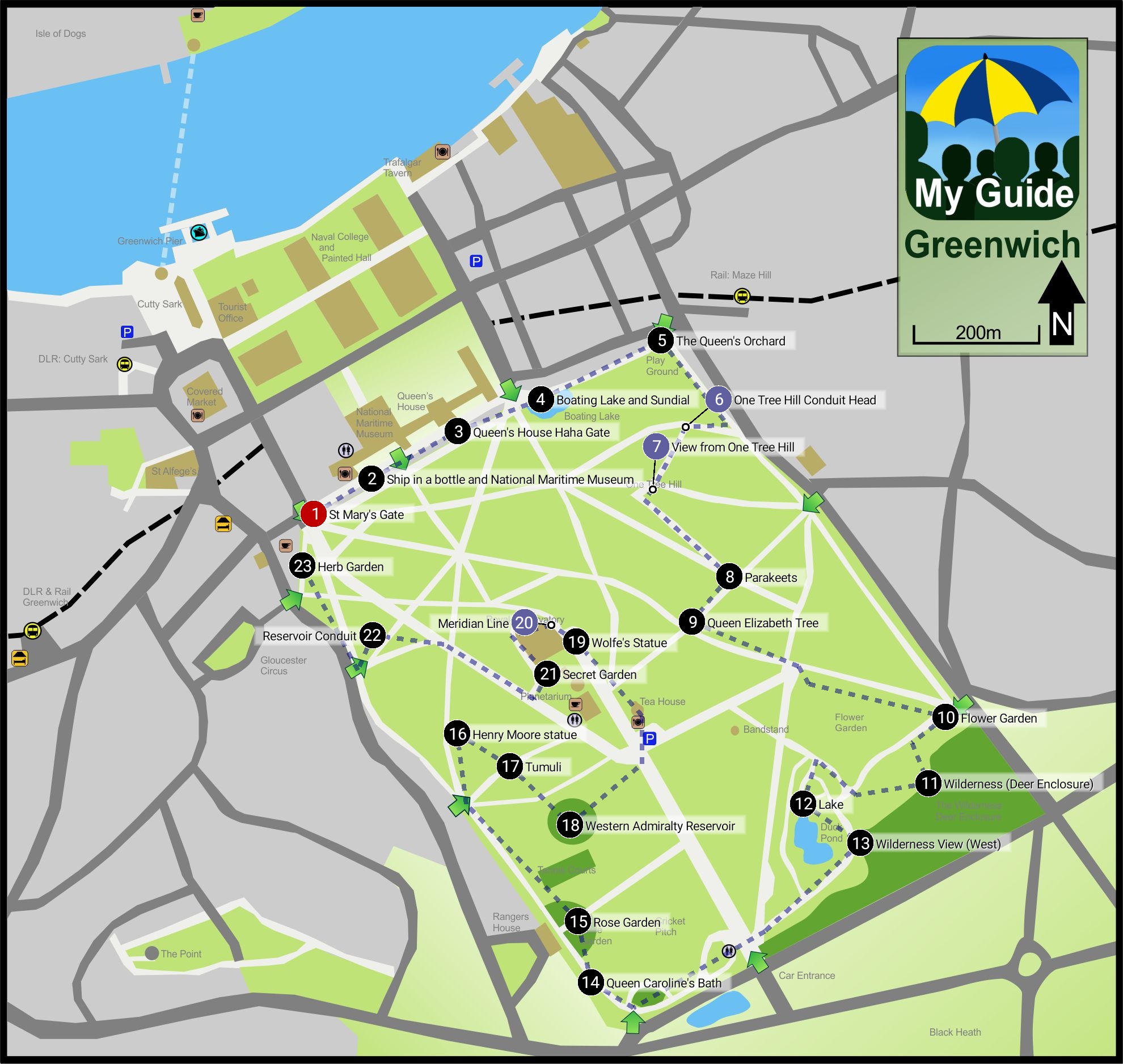
Points of Interest Map Ref
The various points of interest shown on the map are listed below in sequence. You can search for something using the search button above.
It is so much easier to do this in the app plus you have the benefit of location enabling and audio commentary!
St Mary's Gate 1.1
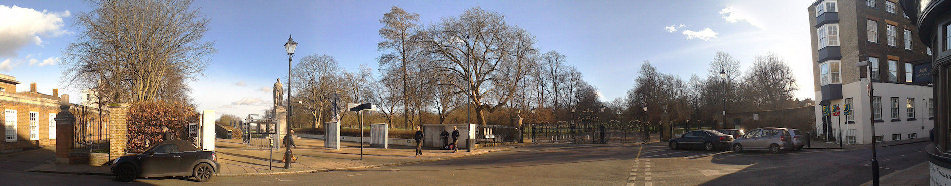
St Mary's Gate
St Mary's Gate is the main entrance to Greenwich Park and is quickly reached from the town centre and covered market.
It is normally closed to traffic, but during the rush-hour cars can travel through here to get to Blackheath.
The park has not always been able to be accessed by the public.
It was originally a royal deer park and only opened up to certain members of the local population in the 18th century.
One of the big attractions of the Greenwich Fair was that while it was on the park was open to all, but in 1830 George VI declared it a public park and today it remains open as one of the Royal Parks of London.
The gate takes its name from the neoclassical St Mary's Church which was once an imposing building on the east side of the gate.
St Mary's Church was built in 1823 to relieve crowding at St Alfege's and looked very much like a smaller version of its older neighbour.
The church was sited in the space where the statue of King William IV is now located and the old Woolwich road that ran under the Queen's house was blocked by its construction and diverted to its current route.
The church was closed and demolished in 1936 when the Maritime Museum opened as church going had declined and it no longer had enough parishioners to keep it open.
Back to the interactive map
St Mary's Gate - Statue of William IV 1.2
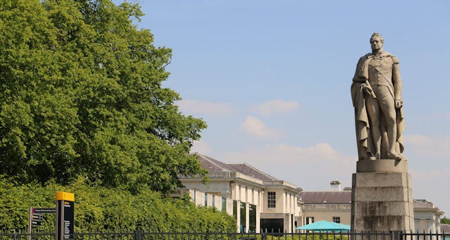
William IV Statue
The statue shows the king in the uniform of the Lord High Admiral.
It is carved in Scottish granite and was London's first statue to be carved in this difficult stone causing numerous challenges for the sculptor Samuel Nixon.
It is very fitting that his statue is here in Greenwich as William IV was known as the Sailor King.
Born in 1765, the third son of George III he entered the navy in 1779, aged 14, and assumed his first command at 20.
He was good friends with the young Nelson for whom he was best man.
The statue was originally unveiled in 1844 on the north side of London Bridge, but following road modifications it was taken to the National Maritime Museum at Greenwich and re-erected where it stands today shortly after the church was demolished.
Back to the interactive map
Ship in a bottle and National Maritime Museum 2.1
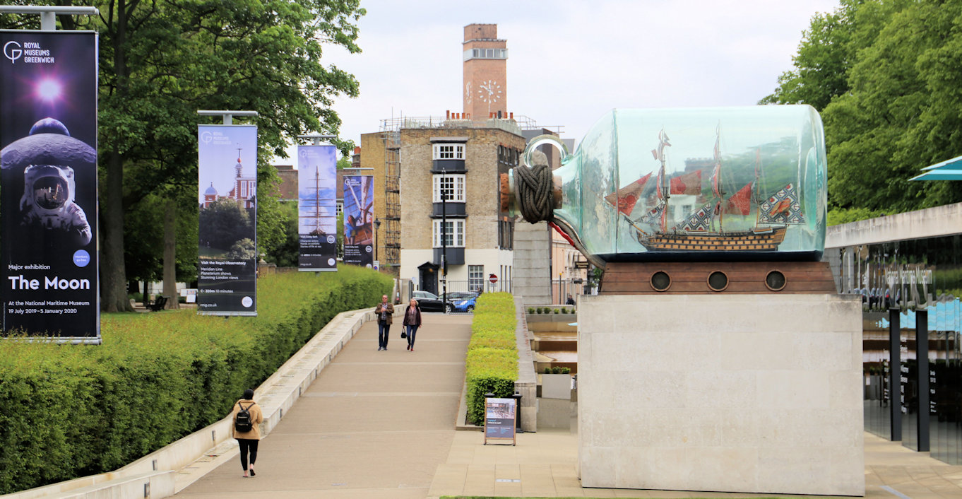
Ship in a bottle
Standing outside the newest part of the museum, the Sammy Ofer wing, you will see a large bottle with a ship in it.
This sculpture by British/Nigerian sculptor Yinka Shonibare is a scaled down replica of Nelson's flagship HMS Victory and was originally displayed on the empty fourth plinth in Trafalgar Square before finding this most suitable of homes after a large fund-raising initiative.
Back to the interactive map
Queen's House Haha Gate 3.1
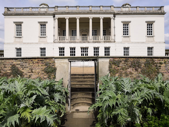
Queen's House Haha
A haha is a ditch and wall frequently used in mansions that face onto land containing animals.
Rather than build a wall to keep the animals off the lawns that would then obscure the view, the wall is sunk into a ditch so that when the landscape is admired from the mansion, in this case the Loggia of the Queen's House, it appears as if there is no wall and the land just extends into park.
Back to the interactive map
Boating Lake and Sundial 4.1
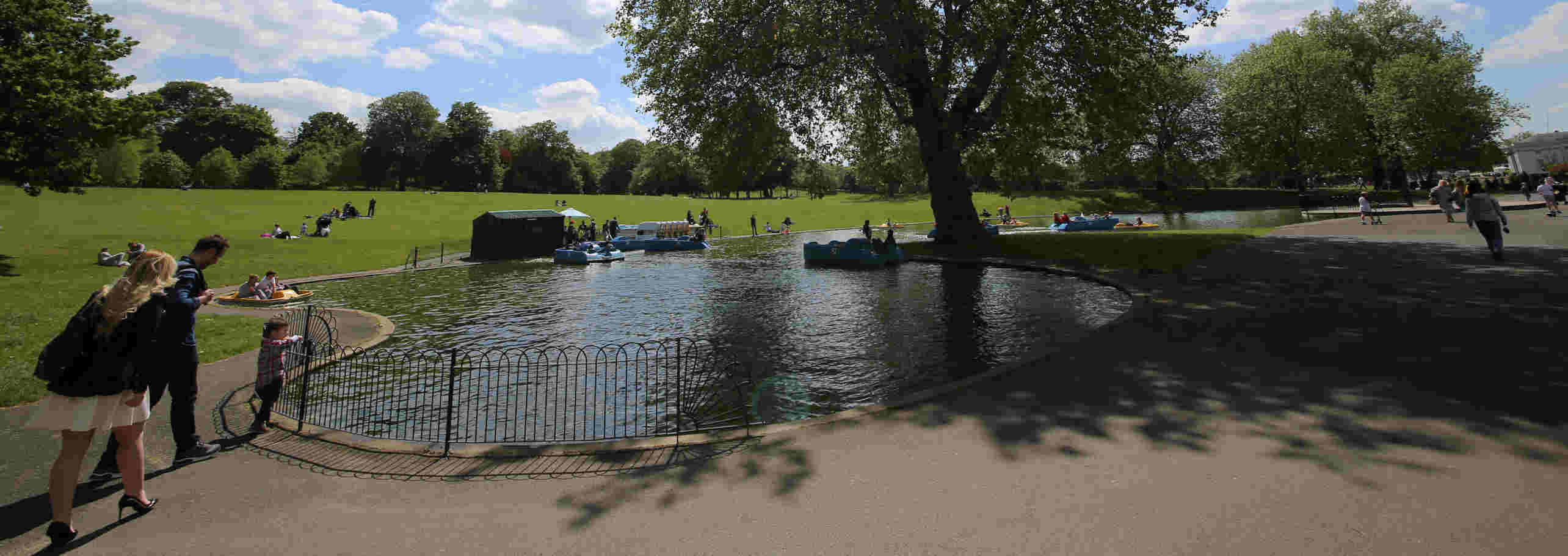
Boating Lake and Sundial
If you are visiting in the summer and really want to "push the boat out", then hire a pedalo and float around the boating lake for a while taking in the view of the observatory.
Next to the well-equipped children's playground, the boating lake has been a popular feature of the park since 1930, but is only filled with water for the summer months.
In 2012 it featured in the Olympics as a water jump for the equestrian cross country event.
The horses came down the hill entering on the south side, turned, jumped and exited on the east.
Details on hiring a boat can be found on their website.
Park Boats
Sundial
On the north side is a sundial which was designed by the celebrated sundial designer Chris Daniel and installed in 1999 to mark the new millennium.
Unfortunately it was meant to be on the meridian line, but is slightly off due to some construction mistakes, and, even worse, it is supposedly not quite oriented correctly so at noon is around 15 minutes fast! However, check the next tab, as this could simply be that some people are not clear how it works.
Back to the interactive map
Using the Sun Dial 4.2
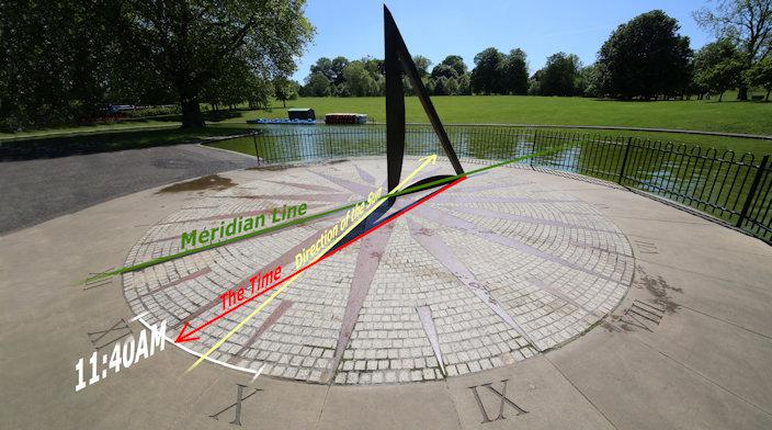
How the Sundial works
If it is a nice sunny day you can check out how the sun dial works.
This is a Double Horizontal Dial and is designed to show both the time and the direction of the sun.
The part that casts the shadow is made from bronze in the shape of a right angled triangle and known as the gnomon.
On the ground is the dial plate which looks like a compass rose.
The time is indicated by the shadow from the sloping edge of the gnomon and the direction of the sun is shown by the shadow from the vertical edge.
Unfortunately the shadow does not quite reach the dial.
Sun dials are obviously not the most accurate way of telling the time, but should generally be accurate to around plus or minus 5 minutes.
This one is particularly simple and so is less accurate than ones which take into account the seasons.
Do remember that the time it shows is Greenwich Mean Time and so will be one hour behind the actual time in the summer.
Back to the interactive map
The Queen's Orchard 5.1
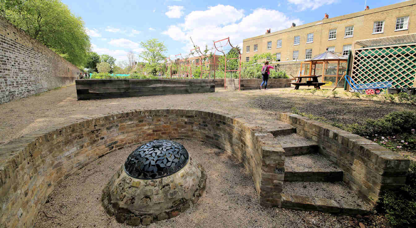
The Queen's Orchard
Staffed and maintained by volunteers, the Queen's Orchard was opened to the public on 15th April 2013 having been returned to the royal park by Greenwich council.
To reflect the legacy of the original Tudor orchards it has been planted with fruit trees that date back to the 14th Century and include apple, pear, cherry and others such as quince and medlar.
As well as the actual orchard there are also two ponds, a well and a number of raised flower beds.
The Orchard is usually only open in the summer on Sunday afternoons, but it may be open on other occasions.
The Queens Orchard
Back to the interactive map
One Tree Hill Conduit Head 6.1
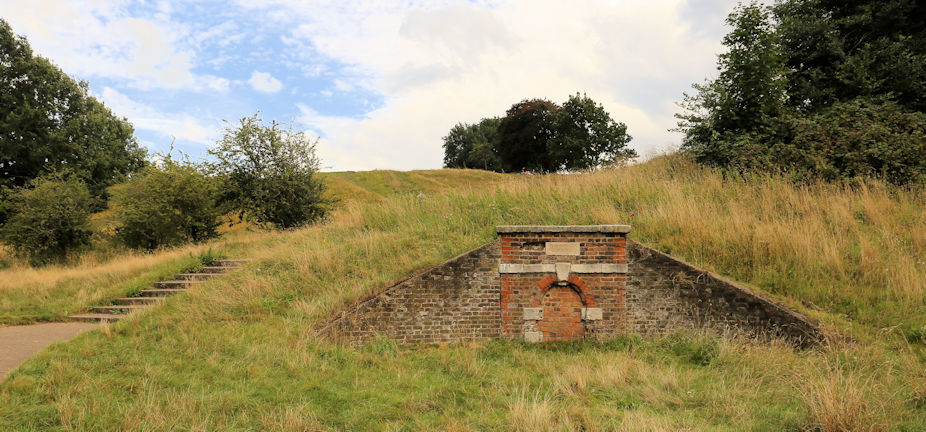
One Tree Hill Conduit Head
This conduit head provided access to the water flowing through the conduit tunnels built under the park.
It is a late 17th century conduit head built in a Classical style and most likely designed by Nicholas Hawksmoor who was the Clerk of the Works at Greenwich between 1698 and 1735.
The central arch, which is now bricked in, would have once provided access to the water in the conduit which flowed down from Blackheath via Queen Elizabeth's Oak.
Conduit heads and houses are rare with three of the thirty three significant examples located in Greenwich.
The plaque above the arch has an inscription which is now illegible
Back to the interactive map
View from One Tree Hill 7.1
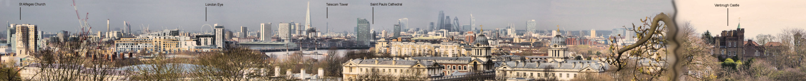
One Tree Hill
Somewhat off the normal tourist trail, One Tree Hill is a lot less busy than the Observatory and does give you a very different perspective of the park.
To the east you can see Vanbrugh Castle and to the west there is probably the best view of the Royal Observatory you can get.
Looking north across the river with the boating lake in the foreground, you have a clearer view of central London, including the London Eye.
Back to the interactive map
Parakeets 8.1
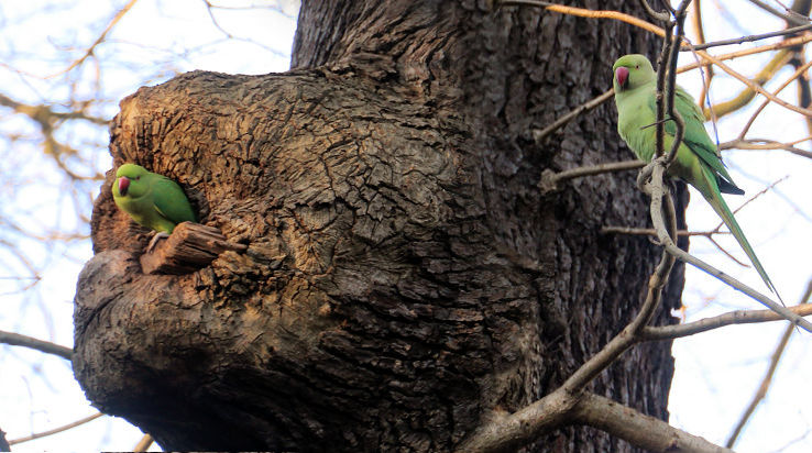
Was that a Parrot?
Near here you will see a water fountain, and around the corner a water trough, one of many tell tale signs of the water conduits that exist under the park and a throw back to when the deer were free to wander here.
As you start walking up the hill into a more wooded area don't be too suprised if you think you've seen or heard a Parrot in one of the trees, you probably have!
Greenwich Park has a thriving colony of bright green Rose-ringed parakeets, a bird that originates from South Asia, predominately India, and is a very common pet.
They are also clearly experienced escapologists!
Although they usually live in the tropics, the rose-ringed parakeet is also common in the foothills of the Himalayas and is, therefore, perfectly capable of over-wintering in Britain.
They also thrive in urban spaces and tend to stay in localised colonies which is why they are generally found concentrated in one place, like here.
Back to the interactive map
Queen Elizabeth Tree 9.1
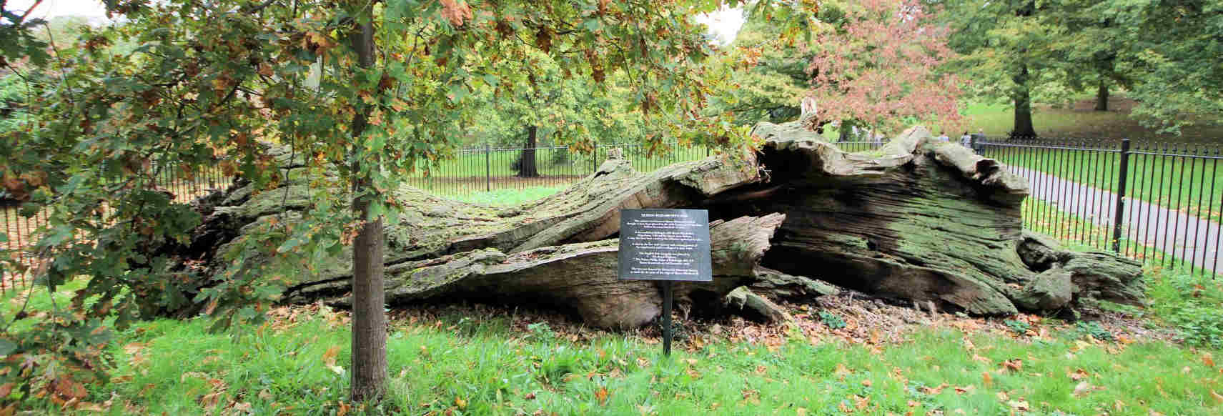
Queen Elizabeth's Oak
An acorn took root sometime in the twelfth century well before 1433 when the park was first enclosed and over 500 years before it was landscaped in 1660.
By then, the ancient oak tree was impressive enough to be spared the axe during the extensive replanting and was instead incorporated as a significant feature.
Although it died around 1880, it was so substantial that it remained standing until 1991 when it was finally toppled by hurricane force winds.
A new oak has been planted in front of the remains of the original.
The name of the tree derives from the story that during her walks in the park the young Queen Elizabeth took refreshments inside the tree, which was hollow and afforded some protection from the elements.
According to some it was later turned into a lock-up for transgressors of park rules through the fitting of a door.
There is also a story that Elizabeth's parents, Henry VIII and Anne Boleyn, danced around this very tree during their courtship.
The Oak is the national tree of England, and this long dead tree is testament to the economic and military importance of the oak forests that once covered the south of England.
These forests played their part in making the area around Greenwich a key location for the construction of ships and hence supported the development of the first major naval power in the world.
Back to the interactive map
Queen Elizabeth Tree - Conduit Cover 9.2
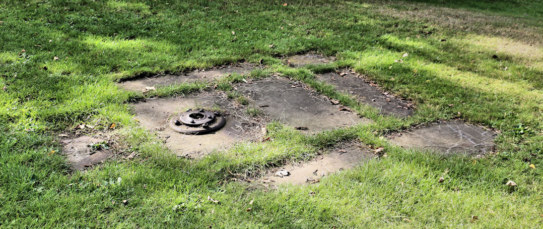
Queen's Oak Conduit Cover
South of the remains of the tree you will see some slabs and an iron seal indicating the presence of one of the two known water conduits under the park.
This one is referred to as the One Tree Hill conduit because it terminates at the foot of that hill in a Conduit Head designed by Nicholas Hawksmoor.
Back to the interactive map
Flower Garden 10.1
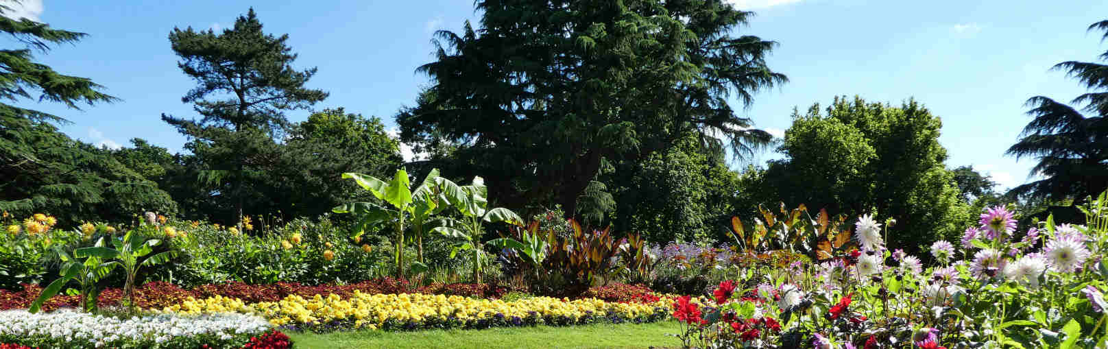
The Flower Garden
The Royal Parks keep this garden in top shape with seasonal plantings so that outside of the winter months you are always greeted with a huge splash of colour.
It is also a nice place for young children to play as no dogs are allowed and the trees make good hiding places.
You can also go and see the deer.
History
Originally this whole area was was part of the wilderness inhabited by the deer, but in 1854 work began to create an ornamental garden, including the construction of nurseries to provide the plant stock which are still working and located in the south east corner.
What plants there were had to be protected from the deer by their own individual fences until the deer were fenced off from the rest of the park as they are today.
The planting continued until 1900 at which point the gardens were relatively unique for a public park.
"The Gardener's Chronicle" said in 1925: "one would imagine oneself to be in the midst of a beautiful garden attached to some stately home", and that is undoubtedly still true today.
Back to the interactive map
Wilderness (Deer Enclosure) 11.1
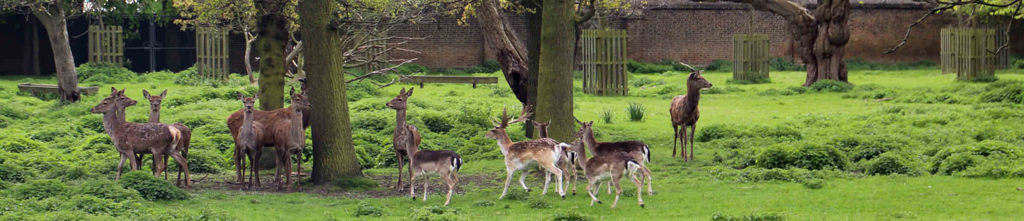
Deer Enclosure
Greenwich Park is the oldest London deer park, having been the home of red deer and fallow deer since they were introduced by Henry VIII in 1510 when he paid a certain Eustace Browne 13 pounds to stock the park.
The red deer are the larger animals with a reddish-brown coat while the fallow deer are smaller with a lighter brown coat with white spots.
If you cannot see any deer from here you can try the other wilderness viewpoint.
Originally the deer were free to roam around the entire park and if you do some roaming yourself you might stumble upon water troughs installed for their benefit.
Increasing visitors and road traffic resulted in them being constrained in what is now referred to as the Wilderness in 1927.
Today the 30 or so deer are carefully managed and you can view them from two areas through fences.
Deer park were important in the Tudor era because hunting was the sport of kings and the aristocracy and having a deer park was the ultimate status symbol of the time.
It was seen as good exercise and recommended by doctors, but was also a demonstration of skills in riding and weapon handling.
It is worth noting that hunting back then was a lot quieter than it would be today as the crossbow was the weapon of choice.
Although guns were available and used in battle they were neither portable nor accurate enough for hunting.
Back to the interactive map
Lake 12.1
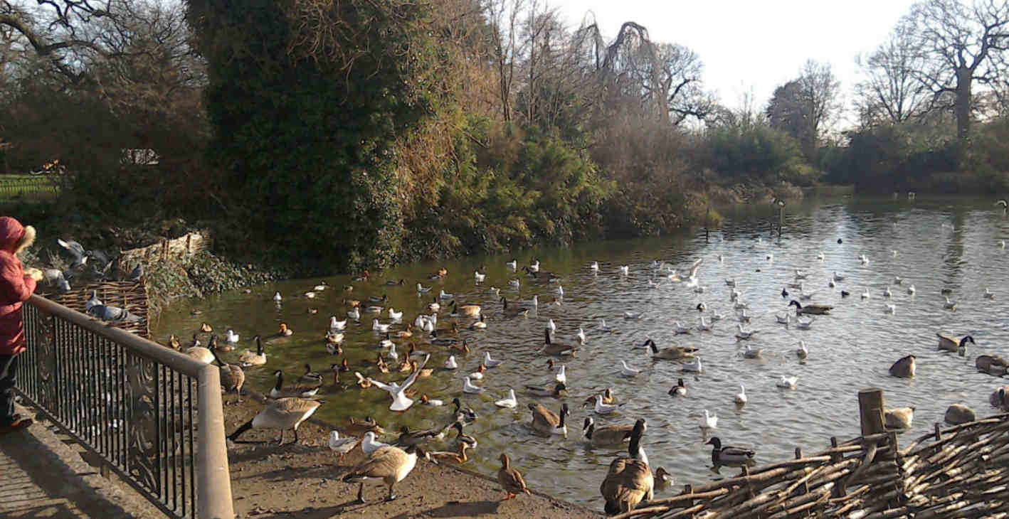
The Duck Pond
The duck pond, or "lake" was introduced to the park as a water feature for the flower garden in the late 19th century and was intended to showcase water loving plants.
In the avian world, word obviously got round that there is plenty of free food going here and as a result the pond in Greenwich Park must have the largest collection of ducks per square metre in the whole of London.
Back to the interactive map
Wilderness View (West) 13.1

Deer Enclosure
Greenwich Park is the oldest London deer park, having been the home of red deer and fallow deer since they were introduced by Henry VIII in 1510 when he paid a certain Eustace Browne 13 pounds to stock the park.
The red deer are the larger animals with a reddish-brown coat while the fallow deer are smaller with a lighter brown coat with white spots.
If you cannot see any deer from here you can try the other wilderness viewpoint.
Originally the deer were free to roam around the entire park and if you do some roaming yourself you might stumble upon water troughs installed for their benefit.
Increasing visitors and road traffic resulted in them being constrained in what is now referred to as the Wilderness in 1927.
Today the 30 or so deer are carefully managed and you can view them from two areas through fences.
Deer park were important in the Tudor era because hunting was the sport of kings and the aristocracy and having a deer park was the ultimate status symbol of the time.
It was seen as good exercise and recommended by doctors, but was also a demonstration of skills in riding and weapon handling.
It is worth noting that hunting back then was a lot quieter than it would be today as the crossbow was the weapon of choice.
Although guns were available and used in battle they were neither portable nor accurate enough for hunting.
Back to the interactive map
Queen Caroline's Bath 14.1
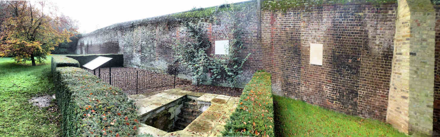
Queen Caroline's Bath
This deep bath is a remnant of Montague House and was only properly excavated in 2001.
It would have been situated in a luxurious bath house within a glass house.
Montague House was a large royal residence and home to Caroline of Brunswick, the wife of King George IV, between 1798 and 1814.
Her marriage to George IV was bitter and divided from the outset and consequently she lived separately from the King at Montague House where she was able to use her status as the Park Ranger to enclose the surrounding 5 acres of the park for her personal use and indulge in her favourite hobby of gardening.
Fed up with her treatment she eventually moved to Italy in 1814 and the King wasted no time in ordering the house demolished.
The walls of the house that adjoined the park boundary were retained and the bricked up spaces where the windows once were can be seen here in the wall behind the bath.
Back to the interactive map
Queen Caroline's Bath - Caroline of Brunswick 14.2
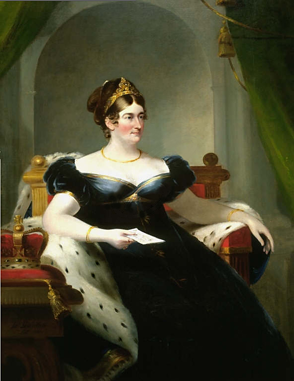
Caroline of Brunswick
Caroline's arranged marriage to George IV started as it was to continue with George having already illegally married a member of the court called Maria Fitzherbert.
Caroline was no pillar of virtue and disliked George as much as he disliked her.
She also had a reputation for being eccentric and unhygienic.
The loveless marriage did produce one daughter, Charlotte, after which the couple separated since the sole purpose of having the child was to get parliament to pay off his debts.
George vindictively used Princess Charlotte as a means to antagonise Caroline, refusing her permission to see her.
Eventually she had had enough of this treatment and Caroline left Britain for Italy in 1814.
After leaving for Italy she remained a very popular figure in Britain and counted Jane Austin as one of her fans: "Poor woman, I shall support her as long as I can, because she is a Woman and because I hate her Husband.
" George IV was heavily despised and when he tried to formalise the divorce it was clear that because of her popular support the House of Commons would never pass it.
To get her to agree he gave her a pension of 50,000 pounds per year, the equivalent of about 4 million pounds today.
Although she loved gardening, this modest daytime activity was in stark contrast to the raucous evenings when she held extravagant parties or would entertain her various lovers.
Back to the interactive map
Rose Garden 15.1
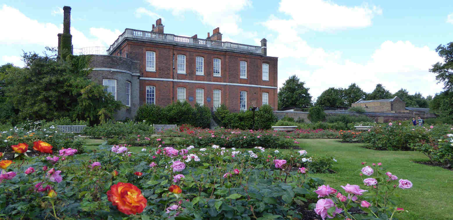
Rangers House and Rose Garden
Installed in the 1960's its fairly obviously the Rose Garden is only really worth visiting between June and July when everything is in bloom and full fragrance, but if you are in the park during those months, and love the sight and aroma of roses do take a look.
Rangers House was built in 1699 by Captain Francis Hosier in a simple Palladian style and was the first house to be sited near the Royal Observatory which had been completed only four years earlier.
If you want to visit Ranger's House you will need to exit the park unless the small gate on the left side is open.
Back to the interactive map
Henry Moore statue 16.1
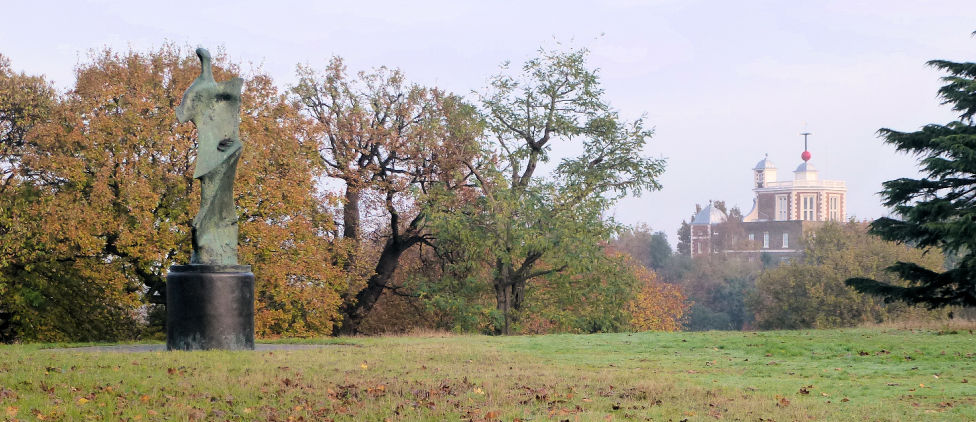
Large Standing Figure: Knife Edge
Henry Moore is a very recognised name and he has a very recognisable style seen clearly here in the Knife Edge.
Less well known is that he also had a passion for exhibiting his works in open space: "Sculpture is an art of the open air.
.
.
I would rather have a piece of my sculpture put in a landscape, almost any landscape, than in, or on, the most beautiful building I know.
"
"Large Standing Figure: Knife Edge" was finished in 1976 and is one of several statues called Knife Edge.
The sculpture is sometimes called Standing Figure (Bone) or Winged Figure.
The sculpture is based on a fragment of a bird's breastbone with the characeristic sharp diagonal detailing, to which a base and a rounded head have been added.
The resulting composition resembles a human torso and evokes comparison to classical greek sculptures.
Moore personally selected this location for his statue when it was installed in 1979, but following concerns over graffiti and a spate of thefts of Bronze statues to be melted down for scrap metal in 2007, it was removed by its owner, the Henry Moore Foundation, for safe keeping.
It was reinstated in time for the 2012 Olympics and it is hoped that the statue will remain where Henry Moore himself chose to place it for many years to come.
Back to the interactive map
Henry Moore statue - Henry Moore 16.2
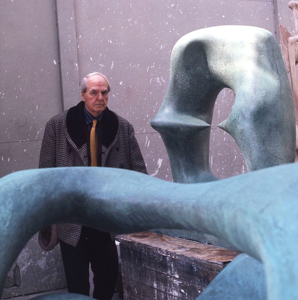
Henry Moore
Henry Moore is a key figure in British art and one of the world's best known abstract sculptors with prominent examples of his work in almost every major city.
Henry Moore's career was much influenced by war.
He started out as a teacher, but following the first world war where he survived a gas attack at the battle of Cambrai he moved into art using his ex-serviceman's grant.
During the second world war he became an official war artist and during this time established a strong reputation culminating in a retrospective of his work at the New York Museum of Modern Art in 1946.
Back to the interactive map
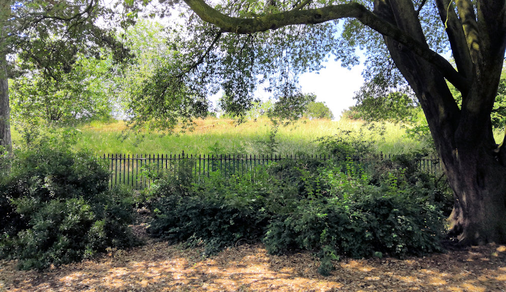
Tumuli 17.1
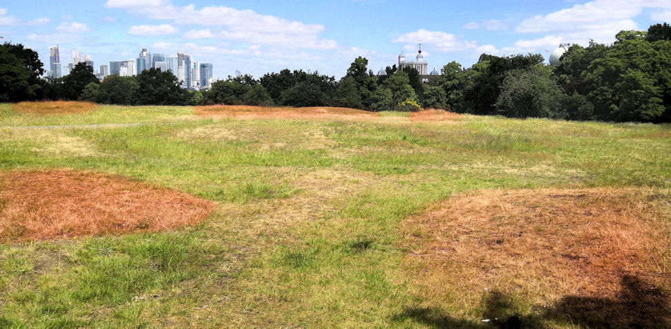
Tumuli - Ancient Burial Site
In this area you will find several low mounds either side of the paved path.
These are ancient burial mounds that are over 1,300 years old and were built by the Anglo Saxons within an ancient cemetery of over 30 barrows of which these are the remains.
Although they may not look especially impressive today, this is one of the best preserved sites in the country.
It is a scheduled historical monument and several important artifacts have been found in excavations over the course of the last 300 years including swords and jewellery.
Back to the interactive map
Western Admiralty Reservoir 18.1
Western Admiralty Reservoir
The reservoir is no longer used and is covered and fenced off so you can only walk around its perimeter and imagine the inside which is extremely impressive.
It was built in 1844 by Sir William Denison to improve the water supply to Greenwich Hospital and the naval dockyard at Deptford where he was the chief engineer.
It is part underground and part above ground.
With a circumference of over 250 metres and a capacity of 5,000,000 litres, it is the largest single structure that fed the maze of historical water conduits under the park.
It is directly connected to the reservoir under Standard House 50 listed in this guide as Reservoir Conduit.
It was only used for 26 years before the hospital was closed and at that point the building was grassed over and screened by trees as it is now.
If you were able to climb down into the building you would find yourself enjoying both the echos and architecture of a huge circular cavern.
It is built in red brick as a set of concentric circular arched roofs supported on columns where they join, providing a large circular space to contain the water.
Back to the interactive map
Wolfe's Statue 19.1
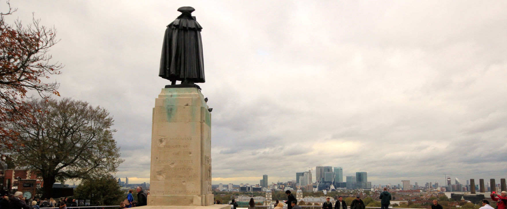
Wolfe
Erected in 1930 as a gift from the Canadian people, this man of bronze has possibly the best permanent view in London.
Major General James Wolfe was responsible for the British victory over the French at the Battle of Quebec in Canada in 1759, and as such very much shaped the Canadian nation, not least their primary language.
Unfortunately he was killed before the battle ended victoriously.
Born in Kent, he was raised in Greenwich which he viewed as his home and chose to be buried in St Alfege's church.
Back to the interactive map
Wolfe's Statue - Bomb Damage 19.2
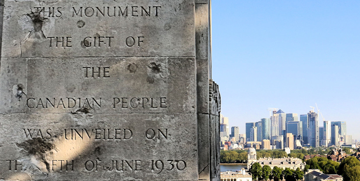
Bomb Damage
On the back of the plinth you will notice a few large indentations.
These were caused by a bomb dropped in the second world war that caused extensive damage to the Observatory.
That was the second bombing of the Observatory, the first being in 1894 when a 16 year old French anarchist named Martial Bourdin blew himself up about 40m from the entrance.
Back to the interactive map
Wolfe's Statue - The Anarchist 19.3
The Anarchist Bomb
The aim of the anarchist attack of 1894 remains a mystery to this day.
It appeared that Martial Bourdin accidentally set off the explosives he was carrying after tripping up about 40m from the entrance.
Miraculously surviving his horrific injuries, he was taken to the Seaman's hospital, but died shortly after, refusing or incapable of explaining his motive.
The fact that he was also found to be carrying an extremely large sum of money further confused things.
The government concluded that he had intended to blow up the observatory because the French were jealous of its success, but the anarchist group he was a member of denied this, pointing out that an anarchist would not try to destroy an institution aiming to make the world a better place.
Such was the interest in the story
and its possible motivation, it inspired several writings including the novel "The Secret Agent" by Joseph Conrad.
Back to the interactive map
Meridian Line 20.1
Zero Degrees
The brass strip in the path here indicates the position of the Greenwich Prime Meridian, so standing astride this line you are partly in the Western Hemisphere and partly in the Eastern Hemisphere.
You can also see the meridian line when visiting the observatory in the courtyard.
It extends in a northerly direction just passing by the west side of the O2 and at night is illuminated by a laser beam.
The first Royal Astronomer at Greenwich, John Flamstead, was given the task of improving the accuracy of the star charts used for navigation by accurately recording and documenting them from the observatory.
As the star measurements were made using a telescope on this line, Greenwich was the reference point and so became zero degrees, neither east, nor west.
The observatory museum will show you some of the telescopes that were used in this work and also covers the important development of accurate clocks that did not need a pendulum by John Harrison.
Back to the interactive map
Meridian Line - Navigation by the stars 20.2
History of Star based Navigation
When the observatory was founded by Charles II in 1675, ships could work out very roughly where they were by locating the position of the sun or stars in the night sky.
To determine how far north or south you were from the equator was done by measuring the angle of Polaris the (Pole Star) to the horizon (or The Southern Cross if you were south of the equator).
Determining how far east or west you were was more challenging because the earth rotates in that direction.
The first thing you had to do was work out the time at your current location using the position of the sun or stars.
Then you needed to know what the time was at a known north to south meridian you had chosen.
Measuring the time using the stars was more accurate than using the sun as you could take multiple height readings for different stars.
To get the time you then had to reference tables of data to translate those angles into a time.
Measuring from the horizon was also made more accuate with the development of the sextant in the mid 18th century.
Apart from the need for a clear sky there were two practical problems with this method.
Firstly the star positions were not very accurately recorded and secondly there was no way to know what the time was at your chosen meridian as pendulum based clocks did not work on a rolling ship.
The work of John Flamstead at the observatory produced the star position tables so that solved the first problem and made Greenwich the default meridian position, but designing an accurate clock that would work on a ship was another matter altogether.
A pendulum based clock was great on dry land where it stayed still and the pendulum swing was a constant frequency, but useless on a ship where even gentle rolling made the pendulum's swing eratic.
The solution to this was developed by John Harrison and replaced the pendulum with a spring loaded oscillating flywheel which moved constantly independent of its orientation, but there were many other engineering innovations required to deliver the required accuracy.
With an accurate clock, a clear sky, and the Greenwich Observatory star data, ships could now tell where they were to within a mile or so, a major breakthrough in safety for all those at sea.
Back to the interactive map
Meridian Line - Really Zero Degrees? 20.3
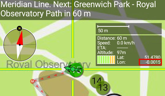
Is this Zero Degrees?
Some of you may be puzzled that your GPS coordinates do not show zero longitude when you are standing on the meridian.
Your GPS will place the meridian about 100 meters east of here.
This is because GPS uses a modern global standard called WGS84 designed to best fit longitude and latitude accurately to existing maps.
Based on this requirement, and the shape of the earth, it had to select its own new meridian line.
Hopefully you are not too disapointed now.
Back to the interactive map
Secret Garden 21.1
Secret Garden
Greenwich locals usually refer to this garden, which was once part of the Observatory, as the "Secret Garden", presumably because it is well hidden despite being in the centre of the park.
Its sheltered and shady location give it a pleasant microclimate and it is the ideal place for a secluded picnic on a hot summers day.
The present entrance was only built in the 1960's and prior to this the garden was part of the observatory and private being accessed directly from the basement of Flamstead House through a tunnel.
Unfortunately the tunnel no longer exists but you can climb up and walk through the paths between the flower beds to get a feeling of how arrival by this unusual method may have felt.
Back to the interactive map
Reservoir Conduit 22.1
Reservoir Conduit
This building known as "Standard House 50" is the access point to an underground reservoir in the hillside behind it constructed around 1695 to provide fresh water to Greenwich Hospital.
It has a volume of 250 square metres and although it has not served its original purpose for a long time it was used during the second world war as an air raid shelter and even had toilets installed.
This building is the most conspicuous of a number of smaller constructions that allowed access to the maze of underground tunnels that exist throughout the park.
The courses of some probably date back to the original Tudor palace of Placentia, but all were modernised when the hospital was built and it is these that can be seen today.
Although these conduits are closed today, they are in many cases large enough to walk through and lined with red brick.
If on your journey round the park you see something that looks like there might be a tunnel behind it or under it, then there almost certainly is.
If you walk round the west side of the building you will see a vent stack and a drain cover.
These are old access points to the conduit which runs under here and then under the road and up to Hyde Vale.
Back to the interactive map
Herb Garden 23.1
The Herb Garden
This small garden is actually pretty large as herb gardens go and was established in 1969.
It has been remodelled a few times since then, most recently to celebrate the millennium.
It is a good place to take a break with its fountain and herb beds filled with familiar aromas.
Back to the interactive map
Check out the android app this map is from.
Scroll through this page to see all the content, or you can tap/click on the points to see what's there if you open the interactive map
| Points of Interest | Map Ref |
The various points of interest shown on the map are listed below in sequence. You can search for something using the search button above.
It is so much easier to do this in the app plus you have the benefit of location enabling and audio commentary!
| St Mary's Gate | 1.1 |
St Mary's Gate
St Mary's Gate is the main entrance to Greenwich Park and is quickly reached from the town centre and covered market.
It is normally closed to traffic, but during the rush-hour cars can travel through here to get to Blackheath.
The park has not always been able to be accessed by the public.
It was originally a royal deer park and only opened up to certain members of the local population in the 18th century.
One of the big attractions of the Greenwich Fair was that while it was on the park was open to all, but in 1830 George VI declared it a public park and today it remains open as one of the Royal Parks of London.
The gate takes its name from the neoclassical St Mary's Church which was once an imposing building on the east side of the gate.
St Mary's Church was built in 1823 to relieve crowding at St Alfege's and looked very much like a smaller version of its older neighbour.
The church was sited in the space where the statue of King William IV is now located and the old Woolwich road that ran under the Queen's house was blocked by its construction and diverted to its current route.
The church was closed and demolished in 1936 when the Maritime Museum opened as church going had declined and it no longer had enough parishioners to keep it open.
Back to the interactive map
| St Mary's Gate - Statue of William IV | 1.2 |
William IV Statue
The statue shows the king in the uniform of the Lord High Admiral.
It is carved in Scottish granite and was London's first statue to be carved in this difficult stone causing numerous challenges for the sculptor Samuel Nixon.
It is very fitting that his statue is here in Greenwich as William IV was known as the Sailor King.
Born in 1765, the third son of George III he entered the navy in 1779, aged 14, and assumed his first command at 20.
He was good friends with the young Nelson for whom he was best man.
The statue was originally unveiled in 1844 on the north side of London Bridge, but following road modifications it was taken to the National Maritime Museum at Greenwich and re-erected where it stands today shortly after the church was demolished.
Back to the interactive map
| Ship in a bottle and National Maritime Museum | 2.1 |
Ship in a bottle
Standing outside the newest part of the museum, the Sammy Ofer wing, you will see a large bottle with a ship in it.
This sculpture by British/Nigerian sculptor Yinka Shonibare is a scaled down replica of Nelson's flagship HMS Victory and was originally displayed on the empty fourth plinth in Trafalgar Square before finding this most suitable of homes after a large fund-raising initiative.
Back to the interactive map
| Queen's House Haha Gate | 3.1 |
Queen's House Haha
A haha is a ditch and wall frequently used in mansions that face onto land containing animals.
Rather than build a wall to keep the animals off the lawns that would then obscure the view, the wall is sunk into a ditch so that when the landscape is admired from the mansion, in this case the Loggia of the Queen's House, it appears as if there is no wall and the land just extends into park.
Back to the interactive map
| Boating Lake and Sundial | 4.1 |
Boating Lake and Sundial
If you are visiting in the summer and really want to "push the boat out", then hire a pedalo and float around the boating lake for a while taking in the view of the observatory.
Next to the well-equipped children's playground, the boating lake has been a popular feature of the park since 1930, but is only filled with water for the summer months.
In 2012 it featured in the Olympics as a water jump for the equestrian cross country event.
The horses came down the hill entering on the south side, turned, jumped and exited on the east.
Details on hiring a boat can be found on their website.
Park Boats
Sundial
On the north side is a sundial which was designed by the celebrated sundial designer Chris Daniel and installed in 1999 to mark the new millennium.
Unfortunately it was meant to be on the meridian line, but is slightly off due to some construction mistakes, and, even worse, it is supposedly not quite oriented correctly so at noon is around 15 minutes fast! However, check the next tab, as this could simply be that some people are not clear how it works.
Back to the interactive map
| Using the Sun Dial | 4.2 |
How the Sundial works
If it is a nice sunny day you can check out how the sun dial works.
This is a Double Horizontal Dial and is designed to show both the time and the direction of the sun.
The part that casts the shadow is made from bronze in the shape of a right angled triangle and known as the gnomon.
On the ground is the dial plate which looks like a compass rose.
The time is indicated by the shadow from the sloping edge of the gnomon and the direction of the sun is shown by the shadow from the vertical edge.
Unfortunately the shadow does not quite reach the dial.
Sun dials are obviously not the most accurate way of telling the time, but should generally be accurate to around plus or minus 5 minutes.
This one is particularly simple and so is less accurate than ones which take into account the seasons.
Do remember that the time it shows is Greenwich Mean Time and so will be one hour behind the actual time in the summer.
Back to the interactive map
| The Queen's Orchard | 5.1 |
The Queen's Orchard
Staffed and maintained by volunteers, the Queen's Orchard was opened to the public on 15th April 2013 having been returned to the royal park by Greenwich council.
To reflect the legacy of the original Tudor orchards it has been planted with fruit trees that date back to the 14th Century and include apple, pear, cherry and others such as quince and medlar.
As well as the actual orchard there are also two ponds, a well and a number of raised flower beds.
The Orchard is usually only open in the summer on Sunday afternoons, but it may be open on other occasions.
The Queens Orchard
Back to the interactive map
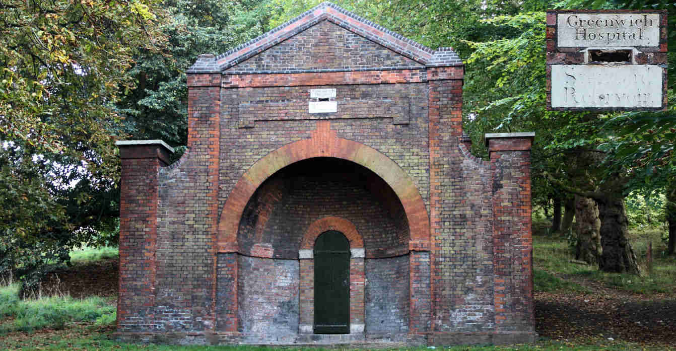
| One Tree Hill Conduit Head | 6.1 |
One Tree Hill Conduit Head
This conduit head provided access to the water flowing through the conduit tunnels built under the park.
It is a late 17th century conduit head built in a Classical style and most likely designed by Nicholas Hawksmoor who was the Clerk of the Works at Greenwich between 1698 and 1735.
The central arch, which is now bricked in, would have once provided access to the water in the conduit which flowed down from Blackheath via Queen Elizabeth's Oak.
Conduit heads and houses are rare with three of the thirty three significant examples located in Greenwich.
The plaque above the arch has an inscription which is now illegible
Back to the interactive map
| View from One Tree Hill | 7.1 |
One Tree Hill
Somewhat off the normal tourist trail, One Tree Hill is a lot less busy than the Observatory and does give you a very different perspective of the park.
To the east you can see Vanbrugh Castle and to the west there is probably the best view of the Royal Observatory you can get.
Looking north across the river with the boating lake in the foreground, you have a clearer view of central London, including the London Eye.
Back to the interactive map
| Parakeets | 8.1 |
Was that a Parrot?
Near here you will see a water fountain, and around the corner a water trough, one of many tell tale signs of the water conduits that exist under the park and a throw back to when the deer were free to wander here.
As you start walking up the hill into a more wooded area don't be too suprised if you think you've seen or heard a Parrot in one of the trees, you probably have!
Greenwich Park has a thriving colony of bright green Rose-ringed parakeets, a bird that originates from South Asia, predominately India, and is a very common pet.
They are also clearly experienced escapologists!
Although they usually live in the tropics, the rose-ringed parakeet is also common in the foothills of the Himalayas and is, therefore, perfectly capable of over-wintering in Britain.
They also thrive in urban spaces and tend to stay in localised colonies which is why they are generally found concentrated in one place, like here.
Back to the interactive map
| Queen Elizabeth Tree | 9.1 |
Queen Elizabeth's Oak
An acorn took root sometime in the twelfth century well before 1433 when the park was first enclosed and over 500 years before it was landscaped in 1660.
By then, the ancient oak tree was impressive enough to be spared the axe during the extensive replanting and was instead incorporated as a significant feature.
Although it died around 1880, it was so substantial that it remained standing until 1991 when it was finally toppled by hurricane force winds.
A new oak has been planted in front of the remains of the original.
The name of the tree derives from the story that during her walks in the park the young Queen Elizabeth took refreshments inside the tree, which was hollow and afforded some protection from the elements.
According to some it was later turned into a lock-up for transgressors of park rules through the fitting of a door.
There is also a story that Elizabeth's parents, Henry VIII and Anne Boleyn, danced around this very tree during their courtship.
The Oak is the national tree of England, and this long dead tree is testament to the economic and military importance of the oak forests that once covered the south of England.
These forests played their part in making the area around Greenwich a key location for the construction of ships and hence supported the development of the first major naval power in the world.
Back to the interactive map
| Queen Elizabeth Tree - Conduit Cover | 9.2 |
Queen's Oak Conduit Cover
South of the remains of the tree you will see some slabs and an iron seal indicating the presence of one of the two known water conduits under the park.
This one is referred to as the One Tree Hill conduit because it terminates at the foot of that hill in a Conduit Head designed by Nicholas Hawksmoor.
Back to the interactive map
| Flower Garden | 10.1 |
The Flower Garden
The Royal Parks keep this garden in top shape with seasonal plantings so that outside of the winter months you are always greeted with a huge splash of colour.
It is also a nice place for young children to play as no dogs are allowed and the trees make good hiding places.
You can also go and see the deer.
History
Originally this whole area was was part of the wilderness inhabited by the deer, but in 1854 work began to create an ornamental garden, including the construction of nurseries to provide the plant stock which are still working and located in the south east corner.
What plants there were had to be protected from the deer by their own individual fences until the deer were fenced off from the rest of the park as they are today.
The planting continued until 1900 at which point the gardens were relatively unique for a public park.
"The Gardener's Chronicle" said in 1925: "one would imagine oneself to be in the midst of a beautiful garden attached to some stately home", and that is undoubtedly still true today.
Back to the interactive map
| Wilderness (Deer Enclosure) | 11.1 |
Deer Enclosure
Greenwich Park is the oldest London deer park, having been the home of red deer and fallow deer since they were introduced by Henry VIII in 1510 when he paid a certain Eustace Browne 13 pounds to stock the park.
The red deer are the larger animals with a reddish-brown coat while the fallow deer are smaller with a lighter brown coat with white spots.
If you cannot see any deer from here you can try the other wilderness viewpoint.
Originally the deer were free to roam around the entire park and if you do some roaming yourself you might stumble upon water troughs installed for their benefit.
Increasing visitors and road traffic resulted in them being constrained in what is now referred to as the Wilderness in 1927.
Today the 30 or so deer are carefully managed and you can view them from two areas through fences.
Deer park were important in the Tudor era because hunting was the sport of kings and the aristocracy and having a deer park was the ultimate status symbol of the time.
It was seen as good exercise and recommended by doctors, but was also a demonstration of skills in riding and weapon handling.
It is worth noting that hunting back then was a lot quieter than it would be today as the crossbow was the weapon of choice.
Although guns were available and used in battle they were neither portable nor accurate enough for hunting.
Back to the interactive map
| Lake | 12.1 |
The Duck Pond
The duck pond, or "lake" was introduced to the park as a water feature for the flower garden in the late 19th century and was intended to showcase water loving plants.
In the avian world, word obviously got round that there is plenty of free food going here and as a result the pond in Greenwich Park must have the largest collection of ducks per square metre in the whole of London.
Back to the interactive map
| Wilderness View (West) | 13.1 |
Deer Enclosure
Greenwich Park is the oldest London deer park, having been the home of red deer and fallow deer since they were introduced by Henry VIII in 1510 when he paid a certain Eustace Browne 13 pounds to stock the park.
The red deer are the larger animals with a reddish-brown coat while the fallow deer are smaller with a lighter brown coat with white spots.
If you cannot see any deer from here you can try the other wilderness viewpoint.
Originally the deer were free to roam around the entire park and if you do some roaming yourself you might stumble upon water troughs installed for their benefit.
Increasing visitors and road traffic resulted in them being constrained in what is now referred to as the Wilderness in 1927.
Today the 30 or so deer are carefully managed and you can view them from two areas through fences.
Deer park were important in the Tudor era because hunting was the sport of kings and the aristocracy and having a deer park was the ultimate status symbol of the time.
It was seen as good exercise and recommended by doctors, but was also a demonstration of skills in riding and weapon handling.
It is worth noting that hunting back then was a lot quieter than it would be today as the crossbow was the weapon of choice.
Although guns were available and used in battle they were neither portable nor accurate enough for hunting.
Back to the interactive map
| Queen Caroline's Bath | 14.1 |
Queen Caroline's Bath
This deep bath is a remnant of Montague House and was only properly excavated in 2001.
It would have been situated in a luxurious bath house within a glass house.
Montague House was a large royal residence and home to Caroline of Brunswick, the wife of King George IV, between 1798 and 1814.
Her marriage to George IV was bitter and divided from the outset and consequently she lived separately from the King at Montague House where she was able to use her status as the Park Ranger to enclose the surrounding 5 acres of the park for her personal use and indulge in her favourite hobby of gardening.
Fed up with her treatment she eventually moved to Italy in 1814 and the King wasted no time in ordering the house demolished.
The walls of the house that adjoined the park boundary were retained and the bricked up spaces where the windows once were can be seen here in the wall behind the bath.
Back to the interactive map
| Queen Caroline's Bath - Caroline of Brunswick | 14.2 |
Caroline of Brunswick
Caroline's arranged marriage to George IV started as it was to continue with George having already illegally married a member of the court called Maria Fitzherbert.
Caroline was no pillar of virtue and disliked George as much as he disliked her.
She also had a reputation for being eccentric and unhygienic.
The loveless marriage did produce one daughter, Charlotte, after which the couple separated since the sole purpose of having the child was to get parliament to pay off his debts.
George vindictively used Princess Charlotte as a means to antagonise Caroline, refusing her permission to see her.
Eventually she had had enough of this treatment and Caroline left Britain for Italy in 1814.
After leaving for Italy she remained a very popular figure in Britain and counted Jane Austin as one of her fans: "Poor woman, I shall support her as long as I can, because she is a Woman and because I hate her Husband.
" George IV was heavily despised and when he tried to formalise the divorce it was clear that because of her popular support the House of Commons would never pass it.
To get her to agree he gave her a pension of 50,000 pounds per year, the equivalent of about 4 million pounds today.
Although she loved gardening, this modest daytime activity was in stark contrast to the raucous evenings when she held extravagant parties or would entertain her various lovers.
Back to the interactive map
| Rose Garden | 15.1 |
Rangers House and Rose Garden
Installed in the 1960's its fairly obviously the Rose Garden is only really worth visiting between June and July when everything is in bloom and full fragrance, but if you are in the park during those months, and love the sight and aroma of roses do take a look.
Rangers House was built in 1699 by Captain Francis Hosier in a simple Palladian style and was the first house to be sited near the Royal Observatory which had been completed only four years earlier.
If you want to visit Ranger's House you will need to exit the park unless the small gate on the left side is open.
Back to the interactive map
| Henry Moore statue | 16.1 |
Large Standing Figure: Knife Edge
Henry Moore is a very recognised name and he has a very recognisable style seen clearly here in the Knife Edge.
Less well known is that he also had a passion for exhibiting his works in open space: "Sculpture is an art of the open air.
.
.
I would rather have a piece of my sculpture put in a landscape, almost any landscape, than in, or on, the most beautiful building I know.
"
"Large Standing Figure: Knife Edge" was finished in 1976 and is one of several statues called Knife Edge.
The sculpture is sometimes called Standing Figure (Bone) or Winged Figure.
The sculpture is based on a fragment of a bird's breastbone with the characeristic sharp diagonal detailing, to which a base and a rounded head have been added.
The resulting composition resembles a human torso and evokes comparison to classical greek sculptures.
Moore personally selected this location for his statue when it was installed in 1979, but following concerns over graffiti and a spate of thefts of Bronze statues to be melted down for scrap metal in 2007, it was removed by its owner, the Henry Moore Foundation, for safe keeping.
It was reinstated in time for the 2012 Olympics and it is hoped that the statue will remain where Henry Moore himself chose to place it for many years to come.
Back to the interactive map
| Henry Moore statue - Henry Moore | 16.2 |
Henry Moore
Henry Moore is a key figure in British art and one of the world's best known abstract sculptors with prominent examples of his work in almost every major city.
Henry Moore's career was much influenced by war.
He started out as a teacher, but following the first world war where he survived a gas attack at the battle of Cambrai he moved into art using his ex-serviceman's grant.
During the second world war he became an official war artist and during this time established a strong reputation culminating in a retrospective of his work at the New York Museum of Modern Art in 1946.
Back to the interactive map
| Tumuli | 17.1 |
Tumuli - Ancient Burial Site
In this area you will find several low mounds either side of the paved path.
These are ancient burial mounds that are over 1,300 years old and were built by the Anglo Saxons within an ancient cemetery of over 30 barrows of which these are the remains.
Although they may not look especially impressive today, this is one of the best preserved sites in the country.
It is a scheduled historical monument and several important artifacts have been found in excavations over the course of the last 300 years including swords and jewellery.
Back to the interactive map
| Western Admiralty Reservoir | 18.1 |
Western Admiralty Reservoir
The reservoir is no longer used and is covered and fenced off so you can only walk around its perimeter and imagine the inside which is extremely impressive.
It was built in 1844 by Sir William Denison to improve the water supply to Greenwich Hospital and the naval dockyard at Deptford where he was the chief engineer.
It is part underground and part above ground.
With a circumference of over 250 metres and a capacity of 5,000,000 litres, it is the largest single structure that fed the maze of historical water conduits under the park.
It is directly connected to the reservoir under Standard House 50 listed in this guide as Reservoir Conduit.
It was only used for 26 years before the hospital was closed and at that point the building was grassed over and screened by trees as it is now.
If you were able to climb down into the building you would find yourself enjoying both the echos and architecture of a huge circular cavern.
It is built in red brick as a set of concentric circular arched roofs supported on columns where they join, providing a large circular space to contain the water.
Back to the interactive map
| Wolfe's Statue | 19.1 |
Wolfe
Erected in 1930 as a gift from the Canadian people, this man of bronze has possibly the best permanent view in London.
Major General James Wolfe was responsible for the British victory over the French at the Battle of Quebec in Canada in 1759, and as such very much shaped the Canadian nation, not least their primary language.
Unfortunately he was killed before the battle ended victoriously.
Born in Kent, he was raised in Greenwich which he viewed as his home and chose to be buried in St Alfege's church.
Back to the interactive map
| Wolfe's Statue - Bomb Damage | 19.2 |
Bomb Damage
On the back of the plinth you will notice a few large indentations.
These were caused by a bomb dropped in the second world war that caused extensive damage to the Observatory.
That was the second bombing of the Observatory, the first being in 1894 when a 16 year old French anarchist named Martial Bourdin blew himself up about 40m from the entrance.
Back to the interactive map
| Wolfe's Statue - The Anarchist | 19.3 |
The Anarchist Bomb
The aim of the anarchist attack of 1894 remains a mystery to this day.
It appeared that Martial Bourdin accidentally set off the explosives he was carrying after tripping up about 40m from the entrance.
Miraculously surviving his horrific injuries, he was taken to the Seaman's hospital, but died shortly after, refusing or incapable of explaining his motive.
The fact that he was also found to be carrying an extremely large sum of money further confused things.
The government concluded that he had intended to blow up the observatory because the French were jealous of its success, but the anarchist group he was a member of denied this, pointing out that an anarchist would not try to destroy an institution aiming to make the world a better place.
Such was the interest in the story
and its possible motivation, it inspired several writings including the novel "The Secret Agent" by Joseph Conrad.
Back to the interactive map
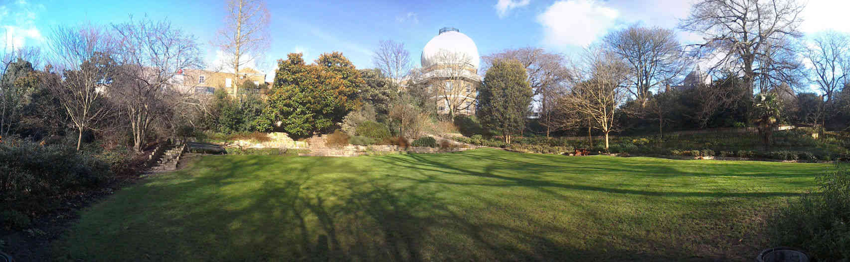
| Meridian Line | 20.1 |
Zero Degrees
The brass strip in the path here indicates the position of the Greenwich Prime Meridian, so standing astride this line you are partly in the Western Hemisphere and partly in the Eastern Hemisphere.
You can also see the meridian line when visiting the observatory in the courtyard.
It extends in a northerly direction just passing by the west side of the O2 and at night is illuminated by a laser beam.
The first Royal Astronomer at Greenwich, John Flamstead, was given the task of improving the accuracy of the star charts used for navigation by accurately recording and documenting them from the observatory.
As the star measurements were made using a telescope on this line, Greenwich was the reference point and so became zero degrees, neither east, nor west.
The observatory museum will show you some of the telescopes that were used in this work and also covers the important development of accurate clocks that did not need a pendulum by John Harrison.
Back to the interactive map
| Meridian Line - Navigation by the stars | 20.2 |
History of Star based Navigation
When the observatory was founded by Charles II in 1675, ships could work out very roughly where they were by locating the position of the sun or stars in the night sky.
To determine how far north or south you were from the equator was done by measuring the angle of Polaris the (Pole Star) to the horizon (or The Southern Cross if you were south of the equator).
Determining how far east or west you were was more challenging because the earth rotates in that direction.
The first thing you had to do was work out the time at your current location using the position of the sun or stars.
Then you needed to know what the time was at a known north to south meridian you had chosen.
Measuring the time using the stars was more accurate than using the sun as you could take multiple height readings for different stars.
To get the time you then had to reference tables of data to translate those angles into a time.
Measuring from the horizon was also made more accuate with the development of the sextant in the mid 18th century.
Apart from the need for a clear sky there were two practical problems with this method.
Firstly the star positions were not very accurately recorded and secondly there was no way to know what the time was at your chosen meridian as pendulum based clocks did not work on a rolling ship.
The work of John Flamstead at the observatory produced the star position tables so that solved the first problem and made Greenwich the default meridian position, but designing an accurate clock that would work on a ship was another matter altogether.
A pendulum based clock was great on dry land where it stayed still and the pendulum swing was a constant frequency, but useless on a ship where even gentle rolling made the pendulum's swing eratic.
The solution to this was developed by John Harrison and replaced the pendulum with a spring loaded oscillating flywheel which moved constantly independent of its orientation, but there were many other engineering innovations required to deliver the required accuracy.
With an accurate clock, a clear sky, and the Greenwich Observatory star data, ships could now tell where they were to within a mile or so, a major breakthrough in safety for all those at sea.
Back to the interactive map
| Meridian Line - Really Zero Degrees? | 20.3 |
Is this Zero Degrees?
Some of you may be puzzled that your GPS coordinates do not show zero longitude when you are standing on the meridian.
Your GPS will place the meridian about 100 meters east of here.
This is because GPS uses a modern global standard called WGS84 designed to best fit longitude and latitude accurately to existing maps.
Based on this requirement, and the shape of the earth, it had to select its own new meridian line.
Hopefully you are not too disapointed now.
Back to the interactive map
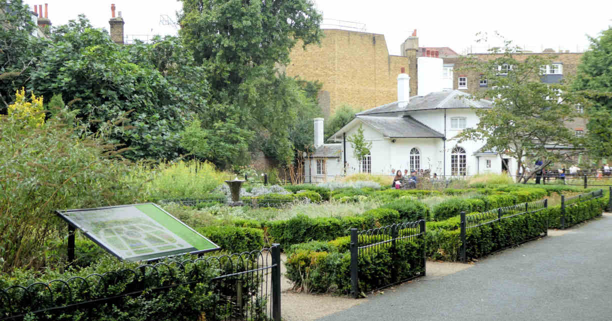
| Secret Garden | 21.1 |
Secret Garden
Greenwich locals usually refer to this garden, which was once part of the Observatory, as the "Secret Garden", presumably because it is well hidden despite being in the centre of the park.
Its sheltered and shady location give it a pleasant microclimate and it is the ideal place for a secluded picnic on a hot summers day.
The present entrance was only built in the 1960's and prior to this the garden was part of the observatory and private being accessed directly from the basement of Flamstead House through a tunnel.
Unfortunately the tunnel no longer exists but you can climb up and walk through the paths between the flower beds to get a feeling of how arrival by this unusual method may have felt.
Back to the interactive map
| Reservoir Conduit | 22.1 |
Reservoir Conduit
This building known as "Standard House 50" is the access point to an underground reservoir in the hillside behind it constructed around 1695 to provide fresh water to Greenwich Hospital.
It has a volume of 250 square metres and although it has not served its original purpose for a long time it was used during the second world war as an air raid shelter and even had toilets installed.
This building is the most conspicuous of a number of smaller constructions that allowed access to the maze of underground tunnels that exist throughout the park.
The courses of some probably date back to the original Tudor palace of Placentia, but all were modernised when the hospital was built and it is these that can be seen today.
Although these conduits are closed today, they are in many cases large enough to walk through and lined with red brick.
If on your journey round the park you see something that looks like there might be a tunnel behind it or under it, then there almost certainly is.
If you walk round the west side of the building you will see a vent stack and a drain cover.
These are old access points to the conduit which runs under here and then under the road and up to Hyde Vale.
Back to the interactive map
| Herb Garden | 23.1 |
The Herb Garden
This small garden is actually pretty large as herb gardens go and was established in 1969.
It has been remodelled a few times since then, most recently to celebrate the millennium.
It is a good place to take a break with its fountain and herb beds filled with familiar aromas.
Back to the interactive map